- Oakridge
-
Oakridge – 41st Avenue
SkyTrain Station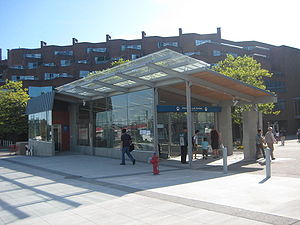
Station statistics Address 510 West 41st Avenue, Vancouver Coordinates 49°13′59″N 123°7′0″W / 49.23306°N 123.116667°WCoordinates: 49°13′59″N 123°7′0″W / 49.23306°N 123.116667°W Structure Underground Platforms Side platforms Tracks 2 Other information Opened August 17, 2009 Accessible 
Code OK Owned by TransLink Fare zone 1 Traffic Passengers (2009) 773,474 boardings (6.79%) Services Preceding station TransLink Following station Langara – 49th Avenuetoward YVR–AirportCanada Line Airporttoward WaterfrontLangara – 49th Avenuetoward Richmond–BrighouseCanada Line RichmondOakridge – 41st Avenue Station is a SkyTrain station on the Canada Line, located at the intersection of West 41st Avenue and Cambie Street in Vancouver, British Columbia, Canada.
Contents
Location
The station entrance is located on the southwest corner of the intersection, adjacent to the entrance to Oakridge Centre. It serves the Oakridge area—consisting of a residential neighbourhood, streetside stores along Cambie Street, and the Oakridge Centre complex—and is within walking distance of Queen Elizabeth Park. The station is located 6 meters underground.[1]
Services
This station is served by the #15 bus providing local surface service along Cambie Street, as well as the #41 bus and a new B-Line service (replacing the current #43 bus), both operating east to Joyce–Collingwood Station and west to the University of British Columbia.
Bus routes
- 15 Downtown / Cambie
- N15 Downtown / Cambie
- 41 UBC / Joyce Station
- 43 UBC / Joyce Station (peak)
References
TransLink Services in Metro Vancouver Proposed lines Evergreen Line VCC–Clark · Commercial–Broadway ■■■ · Renfrew · Rupert · Gilmore · Brentwood Town Centre · Holdom · Sperling – Burnaby Lake · Lake City Way · Production Way – University · Lougheed Town Centre ■ · Burquitlam · Port Moody ■ · Ioco · Coquitlam Central ■ · Douglas College
Passenger ferry and commuter rail SeaBus West Coast Express Waterfront ■■■■ · Port Moody · Coquitlam Central ■ · Port Coquitlam · Pitt Meadows · Maple Meadows · Port Haney · Albion · Mission
Bus routes B-Line Express Route Exchanges Airport Station· Blanca Loop · Capilano University Exchange · Coquitlam Recreation Centre · Dunbar Loop · Guildford Exchange · Haney Place Exchange · Kootenay Loop · Ladner Exchange · Langley Centre · Lonsdale Quay · Marpole Loop · Matthews Exchange · Newton Exchange · Park Royal Exchange · Phibbs Exchange · Port Coquitlam Centre · Scottsdale Exchange · SFU Exchange · South Delta Exchange · South Surrey Park and Ride · Stanley Park Loop · UBC Loop · White Rock Centre · Walnut Grove Park and RideGeneral Trolleybuses in Vancouver
Categories:- Canada Line stations
- Buildings and structures in Vancouver
- Canadian railway station stubs
- Vancouver stubs

Wikimedia Foundation. 2010.