- O'Neill Forebay
-
O’Neill Forebay 
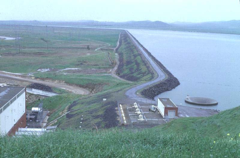
O’Neill Forebay and Dam as seen from left bank. Location Merced County, California Coordinates 37°05′00″N 121°02′33″W / 37.0832°N 121.0426°WCoordinates: 37°05′00″N 121°02′33″W / 37.0832°N 121.0426°W Lake type Reservoir Primary inflows California Aqueduct
Delta–Mendota Canal
San Luis ReservoirPrimary outflows California Aqueduct Catchment area 18 acres (7.3 ha) Basin countries United States Max. length 3 km (1.9 mi) Max. width 3 km (1.9 mi) Surface area 2,250 acres (910 ha) Max. depth 17 m (56 ft) Water volume 56,400 acre·ft (69,600,000 m3) Shore length1 19 km (12 mi) Surface elevation 71 m (233 ft) References U.S. Geological Survey Geographic Names Information System: O'Neill Forebay 1 Shore length is not a well-defined measure. O'Neill Forebay is a forebay to the San Luis Reservoir created by the construction of O'Neill Dam across San Luis Creek approximately 12 miles (19 km) west of Los Banos, California, on the eastern slopes of the Pacific Coast Ranges of Merced County.
Contents
Background
Roughly 2.5 miles (4.0 km) downstream from the San Luis Dam, O'Neill Forbay collects irregular water releases from the San Luis Dam and William R. Gianelli Powerplant in its 56,400 acre·ft (69,600,000 m3) basin. A morning-glory type spillway lies at the left bank of the reservoir. The reservoir is fed by releases from the San Luis Dam as well as from the Delta–Mendota Canal. Water from the Delta–Mendota Canal is lifted a vertical distance of 8 feet (2.4 m) into a channel running 2,200 feet (670 m) into the forebay.[1]
O'Neill Dam
Main article: O'Neill DamO'Neill Dam, constructed from 1963 to 1967, is an 87.5 feet (26.7 m) high, earthfill and rockfill dam, stretching over three miles (5 km) across the valley of San Luis Creek. With a maximum reservoir depth of 57 feet (17 m), peak inflow to the forebay is 15,600 cubic feet (440 m3) per second, from both the San Luis Dam and the Delta–Mendota Canal. Drainage area of the reservoir downstream of the San Luis Dam is only 18 acres (0.073 km2). The O’Neill Pumping-Generating Plant produces 28,000 kilowatts.[1]
Recreation
Notably, the largest striped bass caught in California was caught in the O’Neill Forebay. The fish, 52.5 inches (1,330 mm) long and weighing 70.6 pounds (32.0 kg), was caught on August 5, 2008 by Frank Ualat of Gilroy, California.[2]
References
- ^ a b Bureau of Reclamation. "O’Neill Dam". U.S. Department of the Interior. http://www.usbr.gov/projects/Facility.jsp?fac_Name=O%60Neill%20Dam. Retrieved 2009-04-28.
- ^ "Angler Catches 71.60 Lb. Striped Bass At O’Neill Forebay". The Fish Sniffer. http://www.fishsniffer.com/dbacher/080909stripedbass.html. Retrieved 2009-04-28.
- Department of Water Resources (2009). "Station Meta Data: O’Neill Forebay (ONF)". California Data Exchange Center. State of California. http://cdec.water.ca.gov/cgi-progs/profile?s=ONF&type=dam. Retrieved 2009-04-01.
External links
- "O'Neill Forebay". Geographic Names Information System, U.S. Geological Survey. 19-Jan-1981. http://geonames.usgs.gov/pls/gnispublic/f?p=gnispq:3:::NO::P3_FID:254988. Retrieved 2009-06-15.
Central Valley Project Infrastructure Dams Auburn Dam · B.F. Sisk Dam · Folsom Dam · Friant Dam · Lewiston Dam · New Melones Dam · Nimbus Dam · O'Neill Dam · Red Bluff Diversion Dam · San Justo Dam · Shasta Dam · Sly Park Dam · Spring Creek Dam · Sugar Pine Dam · Trinity Dam · Whiskeytown Dam
Reservoirs Folsom Lake · Millerton Lake · Lake Natoma · New Melones Lake · O'Neill Forebay · San Luis Reservoir · Sugar Pine Reservoir · Shasta Lake · Trinity Lake · Whiskeytown Lake
Aqueducts and canals Clear Creek Tunnel · Contra Costa Canal · Corning Canal · Delta Cross Channel · Delta–Mendota Canal · Friant-Kern Canal · Madera Canal · San Luis Canal · Tehama-Colusa Canal
Rivers American River · Clear Creek · Chowchilla River · Kern River · Sacramento River · San Joaquin River · San Luis Creek · Stanislaus River
Categories:- Landforms of Merced County, California
- Reservoirs in California
- Buildings and structures in Merced County, California
Wikimedia Foundation. 2010.