- Northwestern point of the Lake of the Woods
-
The northwestern point of the Lake of the Woods was a critical landmark for the boundary between U.S. territory and the British possessions to the north. This point was used in the Treaty of Paris in 1783[1] and in later treaties including the Treaty of 1818. This point lies at the corner of the Northwest Angle of Minnesota and is thus the northernmost point in the lower 48 United States. After Canadian Confederation, the point became the basis for the border between Manitoba and Ontario.
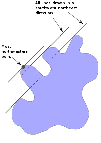 Example demonstrating how the most northwest point of the Lake of the Woods was determined
The northwestern point of the lake was initially difficult to determine because of the lake's numerous islands, bays and peninsulas. In 1824, British explorer David Thompson was hired to find this point. Thompson identified four possibilities but did not identify the point.[2]
In 1825, British astronomer Dr. Johann Tiarks surveyed the lake. Tiarks identified two possibilities for this northwestern point on the lake based on Thompson's maps: the Angle Inlet and Rat Portage. From each point he drew a line in the southwest-northeast direction. If the line intersected the lake at any point, it was not the most northwestern point. This is shown in the example diagram to the right. The only southwest-northeast line that does not intersect the lake runs through the most northwestern point. Tiarks determined the northwestern point to be at the edge of a pond on the Angle Inlet.[3]
In accordance with the 1818 Treaty, the international border ran south from the point as determined by Tiarks to the 49th parallel, and from there west to the Rocky Mountains (and later, the Pacific coast).
References
- ^ "The Paris Peace Treaty of 1783". University of Oklahoma College of Law. 2009. http://www.law.ou.edu/ushistory/paris.shtml. Retrieved 28 Oct 2009.
- ^ Lori Nelson. "Drawing the Line… The Canada-U.S. Border". http://www.lakeofthewoods.com/2008/12/29/drawing-the-line-the-canada-us-border/. Retrieved 15 Oct 2009.
- ^ William E. Lass (1980). Minnesota's Boundary with Canada: Its Evolution Since 1783. Minnesota Historical Society Press. p. 48. ISBN 0873511530. http://books.google.com/books?id=wXAu-xA3y3gC&pg=PA72&lpg=PA72&dq=minnesota%27s+boundary+with+canada&source=bl&ots=aadvTsFGBH&sig=lWD8G5DGUxpwWN0dKRrAr1GiX-A&hl=en&ei=6IPYSoWRCIPg8Qb2v823BQ&sa=X&oi=book_result&ct=result&resnum=2&ved=0CBgQ6AEwAQ#v=snippet&q=tiarks%20northwestern%20point%20thompson&f=false. Retrieved 15 August 2011.
Categories:- 1818 in law
- 1818 in the United States
- Border irregularities of the United States
- Boundary treaties
- Canada–United States border
- Geography of Kenora District, Ontario
- Geography of Minnesota
- Geography of Rainy River District, Ontario
- Geography of Lake of the Woods County, Minnesota
- Legal history of Canada
- Treaties involving territorial changes
- 1818 treaties

Wikimedia Foundation. 2010.