- Northbrae Tunnel
-
Coordinates: 37°53′25″N 122°16′22″W / 37.8903°N 122.2728°W
Northbrae Tunnel 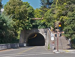
Overview Location Berkeley / Contra Costa County, California, USA Route East Bay Electric Lines;Key System;Solano Avenue Operation Opened Railroad: 1912; Street: 1963 Technical Construction cut-and-cover Length 465 feet (142 m) Number of lanes 2 tracks, then 2 lanes The Northbrae Tunnel, also referred to as the Solano Avenue Tunnel, was built as a commuter electric railroad tunnel in the northern part of Berkeley, California and was later converted to street use.
In 1910. the Southern Pacific Railroad (SP) was electrifying its steam-engine drawn ferry-train line (to San Francisco) from Oakland Pier via Shattuck Avenue to Vine Street in Berkeley and extending it north along the base of the Berkeley Hills to newly developing neighborhoods of Berkeley at Northbrae and Thousand Oaks. The route chosen was adjacent to Henry Street and then on Sutter Street to Northbrae at the intersection of Hopkins and Sutter Streets. At this point a ridge carrying Marin and Los Angeles Avenues blocked the way. After investigating (1) a route around the ridge and (2) a cut through the ridge with bridges over it, it was decided to use the route of the cut but make it a tunnel instead, under Marin and Los Angeles Avenues just west of their intersection with The (Marin) Circle. The cut-and-cover method of tunnel construction was used. The excess soil was used to elevate the railroad right-of-way adjacent to Henry Street so that a bridge could be put in over Eunice Street and the right-of-way would go over a culvert containing Codornices Creek. The tunnel curved to the west so that the railroad could continue through a small canyon to the intersection of Solano Avenue and The Alameda and then to Thousand Oaks station at Solano and Colusa Avenues.[1][2]
The railroad was completed in 1911 and inspection trains were run at the end of that year, with service beginning January 1, 1912.
The SP ferry-train service was changed to bridge-train service operated by its subsidiary, Interurban Electric Railway (IER) across the San Francisco Oakland Bay Bridge in December, 1939. The IER ended service July 26, 1941,[3] but the tracks in Berkeley were made available to the Key System, which extended service to Hopkins and Sutter Streets (the stop formerly called Northbrae) beginning August 6, 1941. Service was extended through the tunnel to a new terminal at Solano Avenue and the Alameda on December 6, 1942.[4] All bridge-train service ended on April 20, 1958.[5]
The tunnel was subsequently converted to city-street use in 1963 by extending Solano Avenue from The Alameda along the former railroad right-of-way through the tunnel to align with Sutter Street.
References
- Ford, Robert S. (1977). Red Trains in the East Bay: The History of the Southern Pacific Transbay Train and Ferry System. Interurbans Specials. 65. Glendale, California: Interurbans Publications. ISBN 0-916374-27-0. http://books.google.com/books?id=PT8fAQAAIAAJ.
- Demoro, Harre W. (1985). The Key Route: Transbay Commuting by Train and Ferry, Part 1. Interurbans Specials. 95. Glendale, California: Interurban Press. ISBN 0-916374-66-1. http://books.google.com/?id=p0wfAQAAIAAJ.
- Guppy, R. T. (September 13, 1912). "Electrification of Oakland Suburban Lines. Development of Southern Pacific Passenger Lines in the Residential Districts on the East Shore of San Francisco Bay". Railway Age Gazette 53 (11): 460–463. http://books.google.com/?id=QrElAAAAMAAJ.
See also
Categories:- Tunnels in the San Francisco Bay Area
- Tunnels completed in 1912

Wikimedia Foundation. 2010.