- North Fork Payette River
-
North Fork Payette River River 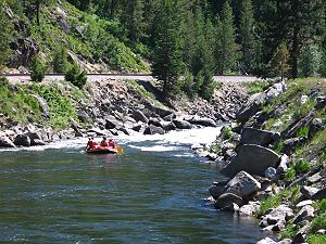 Rafters running rapids on the North Fork Payette River near the mouth
Country United States State Idaho Regions Valley County, Boise County Part of Snake River watershed Tributaries - left Lake Fork, Clear Creek, Round Valley Creek Cities McCall, Cascade, Banks Source Confluence of Trail Creek and Cloochman Creek - location Northwest of Diamond Ridge, Valley County - elevation 6,083 ft (1,854 m) - coordinates 45°10′47″N 115°59′37″W / 45.17972°N 115.99361°W [1] Mouth Payette River - location Banks, Boise County - elevation 2,825 ft (861 m) - coordinates 44°05′06″N 116°06′57″W / 44.085°N 116.11583°W [1] Length 113 mi (182 km), North-south [2] Basin 912 sq mi (2,362 km2) [3] Discharge for Banks, ID - average 1,299 cu ft/s (37 m3/s) [4] - max 8,830 cu ft/s (250 m3/s) - min 36 cu ft/s (1 m3/s) 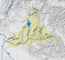 Map of the Payette River watershed including the North Fork
The North Fork Payette River is a river in western Idaho in the United States. It stretches over 113 miles (182 km) from north to south, flowing from the Salmon River Mountains to near Banks, where it joins with the South Fork Payette River to form the Payette River, a tributary of the Snake River. Its watershed comprises more than 900 square miles (2,300 km2) of forested mountains and sprawling lakes and wetlands.
Course
It rises at the confluence of two small streams, Trail Creek and Cloochman Creek, in a meadow deep within the Payette National Forest. The river flows south into Upper Payette Lake then further in that direction through a deep valley into Payette Lake, which lies at the northern end of Long Valley. The river exits from the southern end of the lake near McCall and flows southwards through the broad valley into Lake Cascade, a huge reservoir formed by Cascade Dam. While part of the lake, the North Fork Payette River receives the Lake Fork, its largest tributary, which descends from the mountains to the northeast.[5]
The river leaves the Cascade Dam at Cascade and 5 mi (8.0 km) later enters a gorge, leaving the Long Valley. Idaho State Highway 55 follows the river as it courses south-southwest through the canyon. The gorge starts out as a valley only about 700 feet (210 m) deep, but as the river nears the mouth, it attains its maximum depth below the rim at nearly 3,000 feet (910 m). The North Fork joins with the South Fork near the village of Banks, at an elevation of 2,825 feet (861 m). From there, the river is known as the main stem of the Payette and flows 62 miles (100 km) further west to its confluence with the Snake River near Ontario, Oregon.[5]
See also
References
- ^ a b "North Fork Payette River". Geographic Names Information System, U.S. Geological Survey. 1979-06-21. http://geonames.usgs.gov/pls/gnispublic/f?p=gnispq:3:::NO::P3_FID:387749. Retrieved 2010-10-26.
- ^ "North Fork Payette River Subbasin Assessment". Idaho Department of Environmental Quality. http://www.deq.state.id.us/water/data_reports/surface_water/tmdls/payette_river_nf/payette_river_nf_entire.pdf. Retrieved 2010-10-26.
- ^ "Boundary Descriptions and Names of Regions, Subregions, Accounting Units and Cataloging Units". U.S. Geological Survey. http://water.usgs.gov/GIS/huc_name.html. Retrieved 2010-08-22.
- ^ "USGS Gage #13246000 on the North Fork Payette River near Banks, ID: Water-Data Report 2009". National Water Information System. U.S. Geological Survey. 1947-2009. http://wdr.water.usgs.gov/wy2009/pdfs/13246000.2009.pdf. Retrieved 2010-10-26.
- ^ a b ACME Mapper. USGS Topo Maps for United States (Map). Cartography by United States Geological Survey. http://mapper.acme.com/. Retrieved 2010-10-26.
Categories:- Rivers of Idaho
- Landforms of Valley County, Idaho
- Landforms of Boise County, Idaho


Wikimedia Foundation. 2010.