- North Coast Road (Java)
-
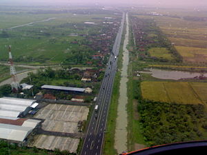 Part of Java North Coast toll road highway aerial view.
The North Coast Road (Indonesian: Jalur Pantai Utara (Jalur Pantura)), is the name for the road, 1,430 km in length,[1] that connects Merak and Banyuwangi on the northern beach of Java, particularly between Jakarta and Surabaya.
The most part of Java north coast road was built during the reign of governor-general of the Dutch East Indies Herman Willem Daendels (1808–1811) and was originally known as the Great Post Road (Indonesian: Jalan Raya Pos Dutch: De Grote Postweg)[2]
Contents
History of construction
Main article: Great Post RoadThe Great Post Road was a military road which was built under the order of King Lodewijk Napoleon who ruled Holland at that time.[3] the road was intended to ease military support, e.g. transfer of soldiers, in order to defend Java from possible British invasion. It connects Anyer in western end and Panarukan in eastern end of Java. After Daendels rule, the eastern road was later extended to Banyuwangi. The Java Great Post Road consist the most parts of present Java North Coast Road. However the original post road is runs through Preanger (Priangan, West Java) highland, from Meester Cornelis (Jatinegara) went south to Buitenzorg (Bogor), and went east to Cianjur, Bandung, Sumedang, and Cirebon. The current north coast road runs through coastal northern West Java which built later after the construction of Daendels' post road. It connects Bekasi, Karawang, Pamanukan, and Cirebon.
Most of today national road network in Java was built during Dutch East Indies era. However during Suharto era around 1980s, the toll road network system was introduced within the whole Java transportation network. The Java toll network highway is continuously expanded, and today some of these toll roads formed Java north coast road.
Extent
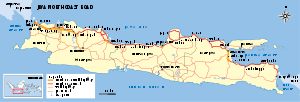 Java's North Coast Road
The road originally ran from Anyer, present day Banten, but formerly West Java to Panarukan, East Java, but later was extended to Banyuwangi.[3] In its current form the North Coast Road extends through five provinces: Banten, DKI Jakarta, West Java, Central Java and East Java. The western end begins at the port of Merak, connecting with Bakauheni in Sumatra, the southern end of the Trans-Sumatran Highway. The eastern end begins at Ketapang, connecting with Gilimanuk in Bali. Sections of the North Coast Road are going to be part of the 13,177 km AH2 route of the Asian Highway Network route, which links Denpasar, Bali with Khosravi, Iran,[4] since some of the AH2 is still under construction. AH2 is a freeway which is limited only for vehicles having at least 4 tires. Beside of that, North Coast Road also comprises the National Highway
 which opens to any vehicles.
Cities
The road connects the largest cities in Java, including Jakarta, Cilegon, Tangerang, Bekasi, Cirebon, Tegal, Pekalongan, Semarang, Rembang, Tuban, Surabaya, Pasuruan, Probolinggo and Banyuwangi.[4]
Toll roads
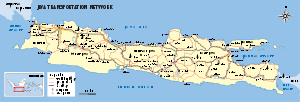 Road network of Java today.
Six toll roads connect:
- Tangerang-Merak Toll Road (Banten)
- Jakarta-Tangerang Toll Road (Banten)
- Jakarta-Cikampek Toll Road(Karawang)
- Palimanan-Kanci Toll Road (Cirebon)
- Kanci-Pejagan Toll Road (Brebes)
- Semarang Inner Toll Road
- Surabaya-Gresik Toll Road
- Surabaya-Gempol Toll Road (Sidoarjo), ends in Porong because of Lapindo Mudflow.
Volume and hazards
This road is a major route for land transportation, being used by a range of 20,000 to 70,000 vehicles daily.[citation needed] However the state of the road varies in condition which can seriously affect traffic flow [5]
The North Coast Road is a major artery during the celebration of the Lebaran holiday, where transit is primarily east to west.
In Cikampek, there is a branch to Bandung (and cities of West Java in the southern part). In Tegal, there is a branch to Purwokerto (and the cities of Central Java in the southern part). In Semarang, there is a branch to east (Surabaya-Banyuwangi) and to the south (Solo-Madiun)
References
- ^ UN Economic & Social Commission for Asia and the Pacific: Asian Highway Database [1] Access date 29 March 2009
- ^ Encyclopædia Britannica: Herman Willem Daendels [2] Access date 29 March 2009
- ^ a b Peter Nas (2002). "Java and De Groote Postweg, La Grande Route, the Great Mail Road, Jalan Raya Pos" (PDF). In: Bijdragen tot de Taal-, Land- en Volkenkunde. 158. pp. 707–725. http://www.leidenuniv.nl/fsw/nas/pdf/NasPratiwoPostweg30-10-2001.pdf. Retrieved 2007-10-25.
- ^ a b UN Economic & Social Commission for Asia and the Pacific: Asian Highway Handbook [3] Access date 29 March 2009
- ^ http://www.thejakartapost.com/news/2006/04/06/bumpy-going-along-java039s-damaged-north-coast-roads.html
Asian Highway Network AH1 · AH2 · AH3 · AH4 · AH5 · AH6 · AH7 · AH8 · AH11 · AH12 · AH13 · AH14 · AH15 · AH16 · AH18 · AH19 · AH25 · AH26 · AH30 · AH31 · AH32 · AH33 · AH34 · AH41 · AH42 · AH43 · AH44 · AH45 · AH46 · AH47 · AH48 · AH51 · AH60 · AH61 · AH62 · AH63 · AH64 · AH65 · AH66 · AH67 · AH68 · AH70 · AH71 · AH72 · AH75 · AH76 · AH77 · AH78 · AH81 · AH82 · AH83 · AH84 · AH85 · AH86 · AH87 · AH88 ·

National Routes of Indonesia Java Indonesian National Route 1 · Indonesian National Route 2 · Indonesian National Route 3 · Indonesian National Route 4 · Indonesian National Route 5 · Indonesian National Route 6 · Indonesian National Route 7 · Indonesian National Route 8 · Indonesian National Route 9 · Indonesian National Route 10 · Indonesian National Route 11 · Indonesian National Route 12 · Indonesian National Route 13 · Indonesian National Route 14 · Indonesian National Route 15 · Indonesian National Route 16 · Indonesian National Route 17 · Indonesian National Route 18 · Indonesian National Route 19 · Indonesian National Route 20 · Indonesian National Route 21 · Indonesian National Route 22 · Indonesian National Route 23 · Indonesian National Route 24 · Indonesian National Route 25
 Categories:
- Roads in Indonesia
- Asian Highway Network


Wikimedia Foundation. 2010.