Norman Park ferry wharf

Norman Park ferry wharf
Norman Park
Norman Park.JPG
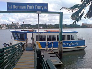
Station statistics
Address Wynnum Road, Norman Park
Coordinates 27°28′27″S 153°03′13″E / 27.4743°S 153.0536°E / -27.4743; 153.0536Coordinates: 27°28′27″S 153°03′13″E / 27.4743°S 153.0536°E / -27.4743; 153.0536
Other information
Accessible Handicapped/disabled access
Owned by Brisbane City Council
Fare zone 2 (TransLink)
Services
Preceding station   CityFerry   Following station
Terminus
Cross River Ferries - Norman Park Terminus

Norman Park is a ferry wharf in the suburb of Norman Park used by the CityFerry on the Brisbane River. The wharf and cross river service closed in 2000 due to poor patronage, but reopened on 15 January 2007.

Closure and reopening

Due to poor patronage caused by poor connections with the CityCat, the wharf and the cross river service closed in 2000.[1] The wharf and the cross river service both were reopened on 15 January 2007, with a proper connection with the CityCat service.[2]

References

  1. ^ Slocombe, Margaret (20 December 2006). "Cross-river ferry is all set to return". South East Advertiser: p. 9. 
  2. ^ Slocombe, Margaret (17 January 2007). "Joy over reinstated river route". South East Advertiser: p. 4. 

External links


Wikimedia Foundation. 2010.

Игры ⚽ Поможем сделать НИР

Look at other dictionaries:

  • Norman Park Ferry Wharf, Brisbane — Brisbaneferries Wharf wharf name=Norman Park region=Brisbane East servicearea1=Norman Park Cross River Ferry DS1=New Farm Park suburb=Norman Park street=Wynnum Road zone=2 berths=1 busconnect=yes trainconnect=no pnr phones toilets… …   Wikipedia

  • New Farm Park Ferry Wharf, Brisbane — Brisbaneferries Wharf wharf name=New Farm Park region=Brisbane Central servicearea1=CityCat servicearea2=Norman Park Cross River Ferry US1=Mowbray Park DS1=Hawthorne US2=Norman Park suburb=New Farm street=Brunswick Street zone=2 berths=1… …   Wikipedia

  • New Farm Park ferry wharf — New Farm Park Station statistics Address Brunswick Street, New Farm Coordinates …   Wikipedia

  • List of Brisbane ferry wharves — This is a list of the suburban ferry wharves operating along the Brisbane River whose services are operated by the Brisbane City Council and its contractor Metrolink Queensland under the TransLink integrated public transport system.For detailed… …   Wikipedia

  • Trams in Brisbane — This article describes Brisbane s tram system, which operated between 1885 and 1969 as well as ongoing proposals since the early 1990s to reinstate a functional tram network. Brief description Brisbane s tram system ran on standard gauge track.… …   Wikipedia

  • TransLink (South East Queensland) — This article is about the South East Queensland public transport system. For other uses, see Translink (disambiguation). TransLink Transit Authority Motto Integrated public transport for South East Queensland Formation …   Wikipedia

  • Rose Bay, New South Wales — Infobox Australian Place | type = suburb name = Rose Bay city = Sydney state = nsw caption = Boats on the shore of Rose Bay lga = Waverley Council postcode = 2029 est = pop = [http://www.censusdata.abs.gov.au/ABSNavigation/prenav/ProductSelect?new… …   Wikipedia

  • Brisbane central business district — Brisbane CBD Brisbane, Queensland Brisbane CBD from Kangaroo Point …   Wikipedia

  • Victoria Harbour (British Columbia) — For other uses, see Victoria Harbour (disambiguation). Not to be confused with Port Victoria or Port of Victoria. Victoria Harbour Aer …   Wikipedia

  • Peterborough — This article is about the city in the United Kingdom. For other uses, see Peterborough (disambiguation). Peterborough   City and unitary authority   …   Wikipedia

Share the article and excerpts

Direct link
Do a right-click on the link above
and select “Copy Link”