- Nong Hin District
-
Nong Hin
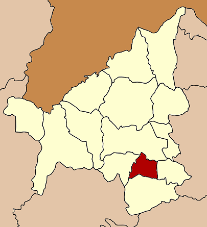
หนองหิน— Amphoe — Amphoe location in Loei Province
Coordinates: 17°7′24″N 101°51′30″E / 17.12333°N 101.85833°ECoordinates: 17°7′24″N 101°51′30″E / 17.12333°N 101.85833°E Country  Thailand
Province Loei Seat Nong Hin Tambon Muban Amphoe established Area – Total 435.0 km2 (168 sq mi) Population (2005) – Total 23,255 – Density 53.5/km2 (138.6/sq mi) Time zone THA (UTC+7) Postal code 42190 Geocode 4214 Nong Hin (Thai: หนองหิน; IPA: [nɔ̌ːŋ hǐn]) is a district (amphoe) of Loei Province, northeastern Thailand.
Contents
Geography
Neighboring districts are (from the north clockwise) Wang Saphung, Pha Khao, Phu Kradueng and Phu Luang.
History
The minor district (King Amphoe) was established on July 1 1997 with territory split off from Phu Kradueng[1].
Following a decision of the Thai government on May 15 2007, all of the 81 minor districts were to be upgraded to full districts[2]. With the publishing in the Royal Gazette on August 24 the upgrade became official [3].
Administration
The district is subdivided into 3 subdistricts (tambon), which are further subdivided into 34 villages (muban). Nong Hin is a township (thesaban tambon) which covers parts of tambon Nong Hin. There are further 3 Tambon administrative organizations (TAO).
No. Name Thai name Villages Inh. 1. Nong Hin หนองหิน 14 9,711 2. Tat Kha ตาดข่า 5 4,060 3. Puan Phu ปวนพุ 15 9,484 References
- ^ "ประกาศกระทรวงมหาดไทย เรื่อง แบ่งเขตท้องที่อำเภอภูกระดึง จังหวัดเลย ตั้งเป็นกิ่งอำเภอหนองหิน" (in Thai). Royal Gazette 118 (Special 51 ง): 19. June 25 1997. http://www.ratchakitcha.soc.go.th/DATA/PDF/2540/E/051/19.PDF.
- ^ "แถลงผลการประชุม ครม. ประจำวันที่ 15 พ.ค. 2550" (in Thai). Manager Online. http://www.manager.co.th/Politics/ViewNews.aspx?NewsID=9500000055625.
- ^ "พระราชกฤษฎีกาตั้งอำเภอฆ้องชัย...และอำเภอเหล่าเสือโก้ก พ.ศ. ๒๕๕๐" (in Thai). Royal Gazette 124 (46 ก): 14–21. August 24 2007. http://www.ratchakitcha.soc.go.th/DATA/PDF/2550/A/046/14.PDF.
External links
Mueang Loei · Na Duang · Chiang Khan · Pak Chom · Dan Sai · Na Haeo · Phu Ruea · Tha Li · Wang Saphung · Phu Kradueng · Phu Luang · Pha Khao · Erawan · Nong Hin
Categories:- Amphoe of Loei
- Isan geography stubs
Wikimedia Foundation. 2010.