- Nyandomsky District
-
Nyandomsky District (English)
Няндомский район (Russian)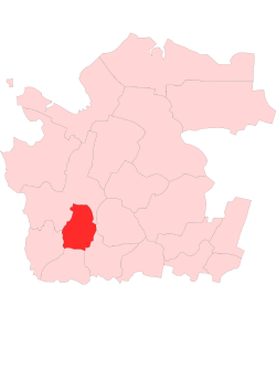
Location of Nyandomsky District within the Arkhangelsk OblastCoordinates: 61°40′N 40°12′E / 61.667°N 40.2°ECoordinates: 61°40′N 40°12′E / 61.667°N 40.2°E Administrative status Country Russia Federal subject Arkhangelsk Oblast Administrative center town of Nyandoma[1] # of cities/towns 1[1] # of urban-type settlements 0[1] # of selsoviets 8[1] Municipal status (as of July 2011) Municipally incorporated as Nyandomsky Municipal District[2] - # of urban settlements 1[2] - # of rural settlements 2[2] Statistics Area 8,100 km2 (3,100 sq mi)[3] Population (2010 Census,
preliminary)30,239 inhabitants[4] Population (2002 Census) 33,465 inhabitants[5] - Urban population 75.9% - Rural population 24.1% Density 4 /km2 (10 /sq mi)[6] Time zone MSD (UTC+04:00)[7] Established July 15, 1929 Official website Nyandomsky District (Russian: Няндомский райо́н) is an administrative district (raion), one of the twenty-one in Arkhangelsk Oblast, Russia.[8] Municipally, it is incorporated as Nyandomsky Municipal District.[2] It is located in the southwest of the oblast and borders with Plesetsky District in the north and west, Shenkursky District in the east, Velsky District in the southeast, Konoshsky District in the south, and Kargopolsky District in the southwest. Its administrative center is the town of Nyandoma.[1] District's population: 30,239 (2010 Census preliminary results);[4] 33,465 (2002 Census);[5] 40,601 (1989 Census).[9] Population of Nyandoma accounts for 73.9% of the district's population.[4]
Contents
History
The area was originally populated by the Finno-Ugric peoples and then colonized by the Novgorod Republic. It was always a remote part of Kargopol lands with sparse population. In the course of the administrative reform carried out in 1708 by Peter the Great, the area was included into Ingermanland Governorate (known from 1710 as Saint Petersburg Governorate). In 1727, it was transferred to the newly established Novgorod Governorate. After a number of administrative reforms, Kargopolsky Uyezd became one of the four uyezds of the newly established Olonets Governorate. In 1894, the decision was taken on the railroad construction from Vologda to Arkhangelsk. It was decided that the railroad would take the shortest route, which means it bypasses Kargopol and traverses the current territory of Nyandomsky District. In 1896, Nyandoma was founded as a railway station.
On July 15, 1929, the uyezds were abolished, the governorates merged into Northern Krai, and Nyandomsky District was established among others. It became a part of Nyandoma Okrug, one of the five in Northern Krai.[10] In 1930, the okrug was abolished, and the district became subordinate to the central administration of Northern Krai. For a short period in the 1930s, the district absorbed some of the areas of abolished Konoshsky District, but in 1935 Konoshsky District was reestablished, and the areas were ceded to it. In 1936, the krai itself was transformed into Northern Oblast. In 1937, Northern Oblast was split into Arkhangelsk Oblast and Vologda Oblast. Nyandomsky District remained in Arkhangelsk Oblast ever since.
Location and geography
The major part of the district belongs to the basin of the Onega River. The Mosha River, a right tributary of the Onega, has its source in Lake Bolshoye Moshenskoye in the southeast of the district and flows northwest dividing the district in two roughly equal parts. The areas in the west of the district drain into the Voloshka River, also a right tributary of the Onega. Minor areas in the east of the district belong to the river basins of the left tributaries of the Vaga River - the Vel, the Padenga, and the Led. An area in the north of the district belongs to the basin of the Mekhrenga River, a right tributary of the Yemtsa. There are many lakes in the district, the biggest of them is Lake Nimengskoye, which belongs to the river basin of the Voloshka.
The major part of the district is covered by coniferous forests (taiga). There are many swamps in the area.
Divisions
Administrative divisions
Administratively, the district is divided into eight selsoviets and one town (Nyandoma).[1] One locality which previously had urban-type settlement status (Shalakusha), was downgraded to a rural locality in 2005. The following selsoviets have been established (the administrative centers are given in parentheses):
- Andreyevsky (Andreyevskaya);
- Burachikhinsky (Burachikhinskaya);
- Lepshinsky (Stupinskaya);
- Limsky (Navolok);
- Moshinsky (Makarovskaya);
- Shalakushsky (Shalakusha);
- Shozhemsky (Shestiozersky);
- Voyezersky (Gridino).
Municipal divisions
Municipally, the district is divided into one urban settlement and two rural settlements (the administrative centers are given in parentheses):[2]
- Nyandomskoye Urban Settlement (Nyandoma);
- Moshinskoye Rural Settlement (Makarovskaya);
- Shalakushskoye Rural Settlement (Shalakusha).
Economy
Industry
The most important industry in the district is timber industry. Food industry is also present[11]
Agriculture
The agriculture in the region is essentially milk and meat production.[11]
Transport
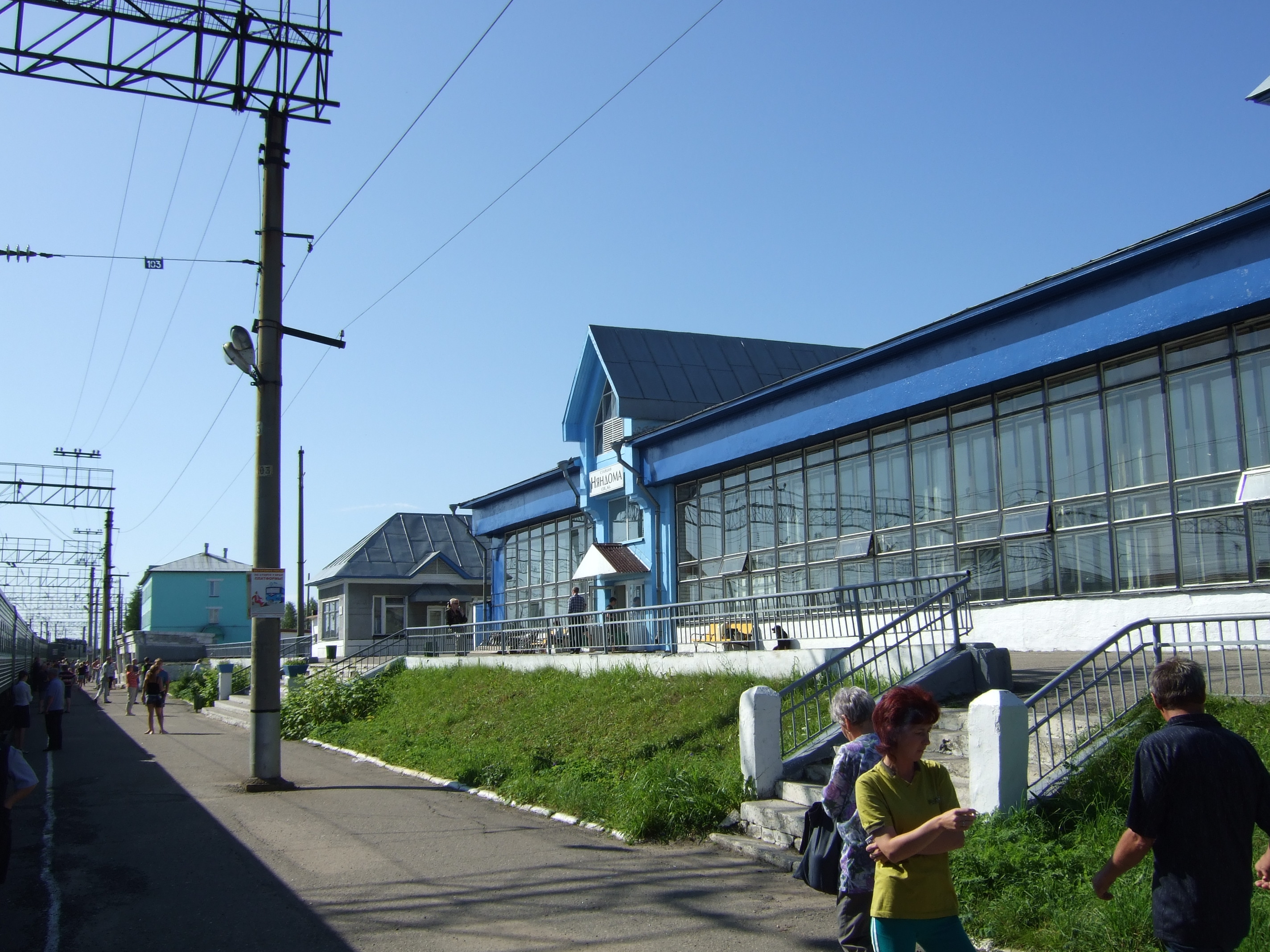
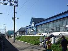 Nyandoma railway station
Nyandoma is on the paved road connecting Dolmatovo, which is on one of the principal highways in Russia, M8 connecting Moscow and Arkhangelsk, with Kargopol. Another paved road, in the southern direction, connects Nyandoma with Konosha.
Nyandoma is located on the railway line between Moscow and Arkhangelsk (built in the south-north direction), and as a matter of fact was founded in 1896 as a railway station and was only granted town status in 1939.[12]
Culture and recreation
The district contains thirty-one objects classified as cultural and historical heritage of local importance.[13] Most of these are chapels and wooden rural houses built prior to 1917.
The only state museum in the district is the House of Nyan, in Nyandoma.[14]
References
Notes
- ^ a b c d Государственный комитет Российской Федерации по статистике. Комитет Российской Федерации по стандартизации, метрологии и сертификации. №ОК 019-95 1 января 1997 г «Общероссийский классификатор объектов административно-территориального деления. Код 11 244», в ред. изменения №168/2011 от 1 октября 2011 г. (State Statistics Committee of the Russian Federation. Committee of the Russian Federation on Standardization, Metrology, and Certification. #OK 019-95 January 1, 1997 Russian Classification of Objects of Administrative Division . Code 11 244, as amended by the Amendment #168/2010 of October 1, 2011. ).
- ^ a b c d Law #258-vneoch.-OZ
- ^ "Няндомский район" (in Russian). Двина-Информ. http://www.dvinainform.ru/clients/32/. Retrieved 4 August 2011.
- ^ a b c Федеральная служба государственной статистики (Federal State Statistics Service) (2011). "Предварительные итоги Всероссийской переписи населения 2010 года (Preliminary results of the 2010 All-Russian Population Census)" (in Russian). Всероссийская перепись населения 2010 года (All-Russia Population Census of 2010). Federal State Statistics Service. http://www.perepis-2010.ru/results_of_the_census/results-inform.php. Retrieved 2011-04-25.
- ^ a b Федеральная служба государственной статистики (Federal State Statistics Service) (2004-05-21). "Численность населения России, субъектов Российской Федерации в составе федеральных округов, районов, городских поселений, сельских населённых пунктов – районных центров и сельских населённых пунктов с населением 3 тысячи и более человек (Population of Russia, its federal districts, federal subjects, districts, urban localities, rural localities—administrative centers, and rural localities with population of over 3,000)" (in Russian). Всероссийская перепись населения 2002 года (All-Russia Population Census of 2002). Federal State Statistics Service. http://www.perepis2002.ru/ct/doc/1_TOM_01_04.xls. Retrieved 2010-03-23.
- ^ The value of density was calculated automatically by dividing the 2010 Census population by the area specified in the infobox. Please note that this value may not be accurate as the area specified in the infobox does not necessarily correspond to the area of the entity proper or is reported for the same year as the population.
- ^ Правительство Российской Федерации. Постановление №725 от 31 августа 2011 г. «О составе территорий, образующих каждую часовую зону, и порядке исчисления времени в часовых зонах, а также о признании утратившими силу отдельных Постановлений Правительства Российской Федерации». Вступил в силу по истечении 7 дней после дня официального опубликования. Опубликован: "Российская Газета", №197, 6 сентября 2011 г. (Government of the Russian Federation. Resolution #725 of August 31, 2011 On the Composition of the Territories Included into Each Time Zone and on the Procedures of Timekeeping in the Time Zones, as Well as on Abrogation of Several Resolutions of the Government of the Russian Federation. Effective as of after 7 days following the day of the official publication).
- ^ Архангельское областное Собрание депутатов. Областной закон №65-5-ОЗ от 23 сентября 2009 г. «Об административно-территориальном устройстве Архангельской области», в ред. Областного закона №150-12-ОЗ от 4 мая 2010 г «О внесении изменений и дополнений в отдельные областные законы». Вступил в силу через десять дней со дня официального опубликования. Опубликован: "Волна", №43, 6 октября 2009 г. (Arkhangelsk Oblast Council of Deputies. Oblast Law #65-5-OZ of September 23, 2009 On the Administrative and Territorial Structure of Arkhangelsk Oblast, as amended by the Oblast Law #150-12-OZ of May 4, 2010 On Amending and Supplementing Certain Oblast Laws. Effective as of the day ten days after the official publication).
- ^ "Всесоюзная перепись населения 1989 г. Численность наличного населения союзных и автономных республик, автономных областей и округов, краёв, областей, районов, городских поселений и сёл-райцентров. (All Union Population Census of 1989. Present population of union and autonomous republics, autonomous oblasts and okrugs, krais, oblasts, districts, urban settlements, and villages serving as district administrative centers.)" (in Russian). Всесоюзная перепись населения 1989 года (All-Union Population Census of 1989). Demoscope Weekly (website of the Institute of Demographics of the State University—Higher School of Economics. 1989. http://demoscope.ru/weekly/ssp/rus89_reg.php. Retrieved 2010-03-23.
- ^ "Постановление Президиума ВЦИК от 15 июля 1929 года о составе округов и районов Северного Края и их центрах" (in Russian). consultant.ru. http://base.consultant.ru/cons/cgi/online.cgi?req=doc;base=ESU;n=15910. Retrieved 12 June 2011.
- ^ a b "Программа развития района" (in Russian). Администрация МО «Няндомский муниципальный район». http://www.nyan-doma.ru/?pid=5&pid2=15&page_id=5024. Retrieved June 13, 2011.
- ^ Энциклопедия Города России. Moscow: Большая Российская Энциклопедия. 2003. p. 322. ISBN 5-7107-7399-9.
- ^ "Памятники истории и культуры народов Российской Федерации" (in Russian). Russian Ministry of Culture. http://kulturnoe-nasledie.ru/. Retrieved 11 June 2011.
- ^ "Няндомский музей "Дом Няна"" (in Russian). Российская сеть культурного наследия. http://www.museum.ru/M3140. Retrieved 13 June 2011.
Sources
- Архангельское областное Собрание депутатов. Областной закон №65-5-ОЗ от 23 сентября 2009 г. «Об административно-территориальном устройстве Архангельской области», в ред. Областного закона №150-12-ОЗ от 4 мая 2010 г «О внесении изменений и дополнений в отдельные областные законы». Вступил в силу через десять дней со дня официального опубликования. Опубликован: "Волна", №43, 6 октября 2009 г. (Arkhangelsk Oblast Council of Deputies. Oblast Law #65-5-OZ of September 23, 2009 On the Administrative and Territorial Structure of Arkhangelsk Oblast, as amended by the Oblast Law #150-12-OZ of May 4, 2010 On Amending and Supplementing Certain Oblast Laws. Effective as of the day ten days after the official publication).
- Архангельское областное Собрание депутатов. Областной закон №258-внеоч.-ОЗ от 23 сентября 2004 г. «О статусе и границах территорий муниципальных образований в Архангельской области (текст в ред. от 15 февраля 2010 г.)», в ред. Областного закона №309-23-ОЗ от 7 июля 2011 г «О внесении изменений и дополнений в отдельные Областные законы в сфере организации и осуществления местного самоуправления». Вступил в силу со дня официального опубликования. Опубликован: "Волна", №38, 8 октября 2004 г. (Arkhangelsk Oblast Council of Deputies. Oblast Law #258-vneoch.-OZ of September 23, 2004 On the Status and Borders of the Territories of the Municipal Formations in Arkhangelsk Oblast (text of rev. of February 15, 2010), as amended by the Oblast Law #309-23-OZ of July 7, 2011 On Amending and Supplementing Several Oblast Laws on the Subject of Organization and Implementation of the Local Self-Government. Effective as of the day of the official publication).
External links
- "Официальный сайт администрации муниципального образования "Няндомский муниципальный район" / Official website of the district administration" (in Russian). http://www.nyan-doma.ru/. Retrieved June 13, 2011.
Administrative divisions of Arkhangelsk Oblast Administrative center: ArkhangelskCities and towns Arkhangelsk · Kargopol · Koryazhma · Kotlas · Mezen · Mirny · Naryan-Mar · Novodvinsk · Nyandoma · Onega · Severodvinsk · Shenkursk · Solvychegodsk · Velsk

Districts (raions) Kargopolsky · Kholmogorsky · Konoshsky · Kotlassky · Krasnoborsky · Lensky · Leshukonsky · Mezensky · Novaya Zemlya · Nyandomsky · Onezhsky · Pinezhsky · Plesetsky · Primorsky · Shenkursky · Solovetsky · Ustyansky · Velsky · Verkhnetoyemsky · Vilegodsky · VinogradovskyCategories:- Districts of Arkhangelsk Oblast

Wikimedia Foundation. 2010.