- Neale Junction
-
Anne Beadell Highway From Leonora-Laverton Road,
Laverton (28°37′S 122°24′E / 28.617°S 122.4°E)To  Stuart Highway,
Coober Pedy (28°56′S 134°45′E / 28.933°S 134.75°E)Length 1340 km State(s) Western Australia, South Australia Region(s) Goldfields-Esperance in Western Australia Permit 1 to 4 required Fuel supply Ilkurlka (28°21′S 127°31′E / 28.35°S 127.517°E) Facilities Ilkurlka (28°21′S 127°31′E / 28.35°S 127.517°E) Connie Sue Highway From Warburton (26°13′S 126°39′E / 26.217°S 126.65°E) To Rawlinna (30°46′S 125°26′E / 30.767°S 125.433°E) Length 650 km (400 mi) State(s) Western Australia Region(s) Goldfields-Esperance in Western Australia Permit 1 required for Warburton Fuel supply Warburton (26°13′S 126°39′E / 26.217°S 126.65°E) Facilities Warburton (26°13′S 126°39′E / 26.217°S 126.65°E) 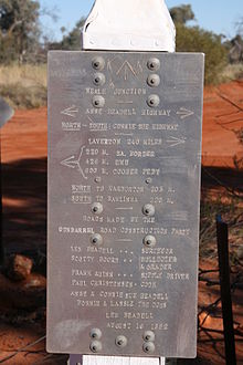 Neale Junction - Len Beadell marker
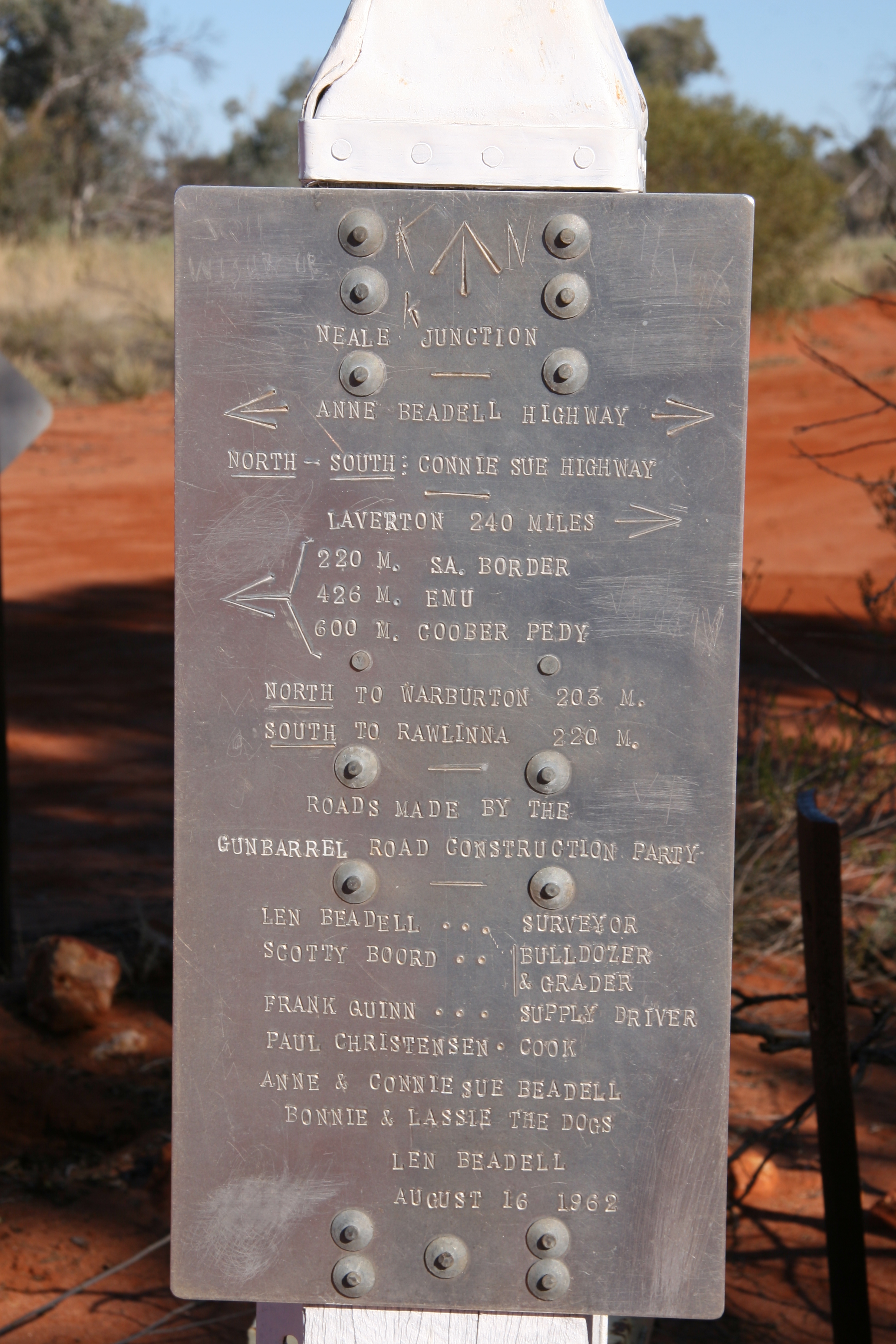
Neale Junction is an isolated location in the Great Victoria Desert of Western Australia, where the Anne Beadell and Connie Sue Highways intersect. It is 172 km (107 mi) west of Ilkurlka.[1] Neale Junction was named after Commander Frank Neale who flew a Percival Gull through the area during the Mackay Aerial Reconnaissance Survey Expedition to Western and South Australia in 1935.[2] [3]
It has a Len Beadell marker and is indicated as suitable for camping on some maps.
Neale Junction is also a location of a large nature reserve that sits north west of the even larger Great Victoria Desert Nature Reserve.[4]
The junction visitors book was deposited in Battye Library in 2002.[5]
Contents
See also
Notes
- ^ Battye Library, MN 2082, Neale Junction, ACC 5853A. Neale Junction is the crossroads of the Rawlinna-Warburton road and the road from Laverton to South Australia.
- ^ Notes from Battye Library record: - Named after Commander R.F.C. Neale, the pilot who flew the Mackay Aerial Reconnaissance Survey Expedition in 1935, the name was approved on 17 September 1963
- ^ Bennett, Harry T. (ca. 1937) Donald MacKay aerial reconnaissance survey expedition [cartographic material] : Northern Territory, South and Western Australia/ compiled from data by Commander Harry T. Bennett and Capt. F. Neale. held in State Reference Library of Western Australia roll 29
- ^ (2008) In the tracks of Len Beadell : plants and animals of Neale Junction Nature Reserve, 28 September - 11 October 2008 : expedition briefing / Department of Environment and Conservation in association with University of Western Australia. Perth, W.A.: Dept. of Environment and Conservation, 2008.
- ^ Completed visitors book ACC - 5853A/1 17 April 1901 to 1 July 2002 was retrieved from the visitors box at the Junction by Ian Murray of Explorer Tours in 2002.
References
- Hema Maps Australia's Great Desert Tracks. Eight Mile Plains, Qld. : Hema Maps, 2005. 3rd ed. Scale 1:1,250 000 ; Lambert conformal conic proj. (E 119°00'--E 129°20'/S 024°35'--S 032°30') ISBN 1865001619
External links
 Road infrastructure in Western Australia
Freeways 
Metropolitan highways Highways and major roads Albany Highway • Brand Highway • Brockman Highway • Brookton Highway • Bussell Highway • Coalfields Road • Coolgardie-Esperance Highway • Dampier Highway • Derby Highway • Eyre Highway • Forrest Highway • Geraldton-Mount Magnet Road • Goldfields Highway • Great Eastern Highway • Great Northern Highway • Great Southern Highway • Indian Ocean Drive • Mandjoogoordap Drive • Muirs Highway • North West Coastal Highway • Old Coast Road • South Coast Highway • South Western Highway • Vasse Highway • Victoria HighwayOutback Tracks Anne Beadell Highway • Buntine Highway • Canning Stock Route • Cape Leveque Road • Connie Sue Highway • Duncan Road • Gary Highway • Gibb River Road • Great Central Road • Gunbarrel Highway • Kalumburu Road • Tanami RoadCategories:- Tracks in remote areas of Western Australia
- Goldfields-Esperance
Wikimedia Foundation. 2010.