- National Register of Historic Places listings in Portland, Maine
-
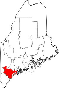 Location of Cumberland County in Maine
This is a list of the National Register of Historic Places listings in Portland, Maine.
This is intended to be a complete list of the properties and districts on the National Register of Historic Places in Cumberland County, Maine, United States. Latitude and longitude coordinates are provided for many National Register properties and districts; these locations may be seen together in a Google map.[1]
There are 221 properties and districts listed on the National Register in the county, including 11 National Historic Landmarks. 136 of these properties and districts, including 7 National Historic Landmarks, are located outside of Portland, and are listed separately, while the properties and districts in Portland are listed here. Another property in Portland was once listed but has been removed.
-
- This National Park Service list is complete through NPS recent listings posted November 10, 2011.[2]
Current listings
[3] Landmark name[4] Image Date listed Location City or Town Summary 1 Abyssinian Meeting House 
February 3, 2006 73-75 Newbury St.
43°39′44″N 70°14′58″W / 43.66222°N 70.24944°WPortland 2 Back Cove October 16, 1989 Roughly Baxter Boulevard along Back Cove from Baxter to Veranda Sts.
43°40′25″N 70°16′15″W / 43.67361°N 70.27083°WPortland 3 Portland 4 Battery Steele October 20, 2005 Florida Ave. on Peaks Island
43°39′32″N 70°10′50″W / 43.65889°N 70.18056°WPortland 5 Harrison B. Brown House 
June 23, 1980 400 Danforth St.
43°38′39″N 70°16′19″W / 43.64417°N 70.27194°WPortland 6 J.B. Brown Memorial Block May 23, 1978 Congress and Casco Sts.
43°39′21″N 70°15′42″W / 43.65583°N 70.26167°WPortland 7 A.B. Butler House 
May 8, 1974 4 Walker St.
43°38′51″N 70°16′11″W / 43.6475°N 70.26972°WPortland 8 Cathedral of the Immaculate Conception June 20, 1985 Cumberland Ave. and Congress St.
43°39′41″N 70°15′17″W / 43.66139°N 70.25472°WPortland 9 Leonard Bond Chapman House April 23, 1980 90 Capisic St.
43°39′43″N 70°18′10″W / 43.66194°N 70.30278°WPortland 10 Chestnut Street Methodist Church October 20, 1977 11-19 Chestnut St.
43°39′34″N 70°15′30″W / 43.65944°N 70.25833°WPortland 11 Charles Q. Clapp Block January 31, 1978 Congress Sq.
43°39′15″N 70°15′47″W / 43.65417°N 70.26306°WPortland 12 Charles Q. Clapp House 
February 23, 1972 97 Spring St.
43°39′13″N 70°15′43″W / 43.65361°N 70.26194°WPortland 13 Deering Oaks 
October 16, 1989 Roughly bounded by Interstate 295, Forest St., Park Ave., and Deering Ave.
43°39′32″N 70°16′20″W / 43.65889°N 70.27222°WPortland 14 Deering Street Historic District 
January 27, 1983 Congress, Deering, Mellen, and State Sts.
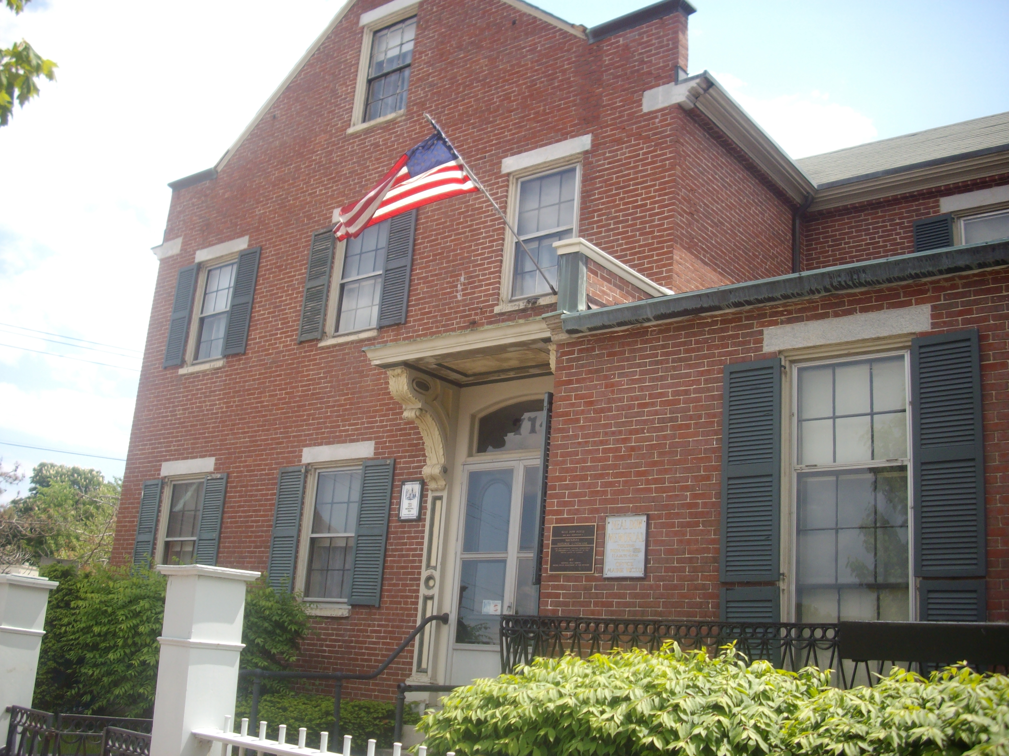
43°39′17″N 70°16′7″W / 43.65472°N 70.26861°WPortland 15 Gen. Neal Dow House 
April 11, 1973 714 Congress St.
43°39′11″N 70°16′12″W / 43.65306°N 70.27°WPortland 16 Nathaniel Dyer House April 15, 1987 168 York St.
43°38′57″N 70°15′38″W / 43.64917°N 70.26056°WPortland 17 Eastern Cemetery 
December 12, 1973 Congress St. at its junction with Mountfort St.
43°39′46″N 70°15′3″W / 43.66278°N 70.25083°WPortland 18 Eastern Promenade October 16, 1989 Roughly bounded by Eastern Promenade and Casco Bay
43°40′20″N 70°14′50″W / 43.67222°N 70.24722°WPortland 19 Engine Company Number Nine Firehouse October 28, 2010 17 Arbor St.
43°41′8″N 70°17′34″W / 43.68556°N 70.29278°WPortland 20 Everett Chambers May 19, 2006 47-55 Oak St.
43°39′18″N 70°15′42″W / 43.655°N 70.26167°WPortland 21 Evergreen Cemetery 
June 18, 1992 Off the western side of Stevens Ave., north of its junction with Brighton Ave.
43°40′51″N 70°18′4″W / 43.68083°N 70.30111°WPortland 22 Fifth Maine Regiment Community Center January 5, 1978 Seashore Ave. on Peaks Island
43°39′10″N 70°11′36″W / 43.65278°N 70.19333°WPortland 23 First Baptist Church January 31, 1978 353 Congress St.
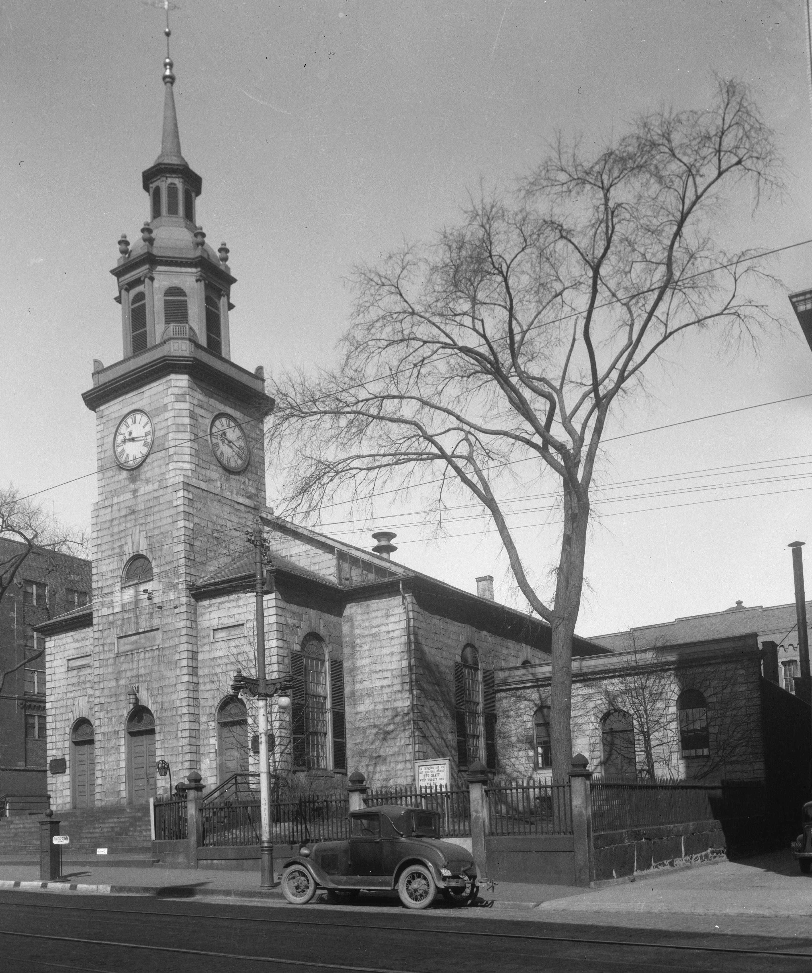
43°39′37″N 70°15′20″W / 43.66028°N 70.25556°WPortland 24 First Parish Church 
January 12, 1973 425 Congress St.
43°39′30″N 70°15′32″W / 43.65833°N 70.25889°WPortland 25 Fort Gorges 
August 28, 1973 East of Portland on Hog Island in Portland Harbor
43°39′46″N 70°13′18″W / 43.66278°N 70.22167°WPortland 26 Fort McKinley Historic District March 21, 1985 Great Diamond Island
43°41′0″N 70°11′47″W / 43.683333°N 70.19639°WPortland 27 The Gothic House 
December 31, 1974 387 Spring St.
43°38′45″N 70°16′30″W / 43.64583°N 70.275°WPortland 28 Green Memorial A.M.E. Zion Church January 17, 1973 46 Sheridan St.
43°39′50″N 70°14′58″W / 43.66389°N 70.24944°WPortland 29 Byron Greenough Block March 10, 1977 Free and Middle Sts.
43°39′25″N 70°15′28″W / 43.65694°N 70.25778°WPortland 30 Griffin House July 19, 1984 200 High St.
43°39′21″N 70°15′59″W / 43.65583°N 70.26639°WPortland 31 Hamblen Block 
July 21, 1983 188-194 Danforth St.
43°38′54″N 70°15′50″W / 43.64833°N 70.26389°WPortland 32 Hamblen Development Historic District June 18, 1992 188-208 Danforth St.
43°38′54″N 70°15′50″W / 43.64833°N 70.26389°WPortland 33 Asa Hanson Block December 31, 2001 548-550 Congress St.
43°39′19″N 70°15′43″W / 43.65528°N 70.26194°WPortland 34 How Houses January 20, 1980 Danforth and Pleasant Sts.
43°39′14″N 70°15′30″W / 43.65389°N 70.25833°WPortland 35 Daniel How House April 24, 1973 23 Danforth St.
43°39′14″N 70°15′30″W / 43.65389°N 70.25833°WPortland 36 Joseph Holt Ingraham House 
July 16, 1973 51 State St.
43°39′0″N 70°15′41″W / 43.65°N 70.26139°WPortland 37 Lancaster Block September 29, 1982 474 Congress St.
43°39′25″N 70°15′35″W / 43.65694°N 70.25972°WPortland 38 Adam P. Leighton House September 29, 1982 261 Western Promenade
43°39′4″N 70°16′34″W / 43.65111°N 70.27611°WPortland 39 Lincoln Park 
October 16, 1989 Bounded by Pearl, Franklin, Market, and Federal Sts.
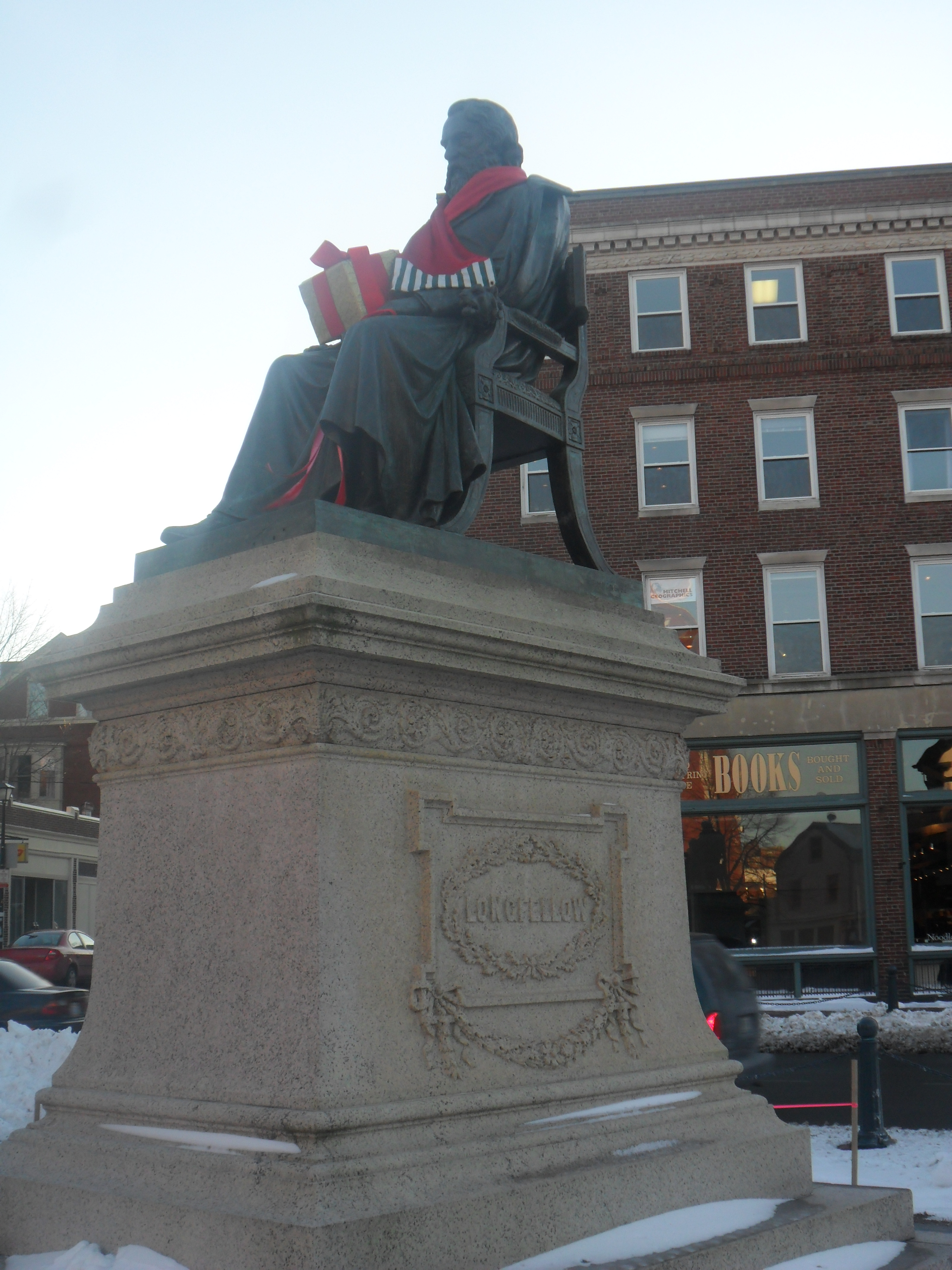
43°39′35″N 70°15′18″W / 43.65972°N 70.255°WPortland 40 Henry Wadsworth Longfellow Monument 
April 5, 1990 Southeastern corner of State and Congress Sts.
43°39′11″N 70°16′2″W / 43.65306°N 70.26722°WPortland 41 Maine Archeological Site No. 9-16 May 7, 1979 Address Restricted Portland 42 Maine Central Railroad General Office Building January 7, 1988 222-224 St. John St.
43°39′3″N 70°16′48″W / 43.65083°N 70.28°WPortland 43 Maine Eye and Ear Infirmary September 25, 1986 794-800 Congress St.
43°39′13″N 70°16′24″W / 43.65361°N 70.27333°WPortland 44 Maine Historical Society November 17, 1980 485 Congress St.
43°39′25″N 70°15′38″W / 43.65694°N 70.26056°WPortland 45 Maine Publicity Bureau Building January 26, 1990 3 St. John St.
43°38′39″N 70°16′36″W / 43.64417°N 70.27667°WPortland 46 Marine Hospital August 21, 1974 331 Veranda St.
43°41′18″N 70°14′51″W / 43.68833°N 70.2475°WPortland 47 Mariner's Church 
April 23, 1973 368-374 Fore St.
43°39′23″N 70°15′11″W / 43.65639°N 70.25306°WPortland 48 Masonic Temple February 11, 1982 415 Congress St.
43°39′32″N 70°15′30″W / 43.65889°N 70.25833°WPortland 49 McLellan-Sweat Mansion 
March 5, 1970 111 High St.
43°39′12″N 70°15′45″W / 43.65333°N 70.2625°WPortland 50 Mechanics' Hall 
October 3, 1973 519 Congress St.
43°39′23″N 70°15′43″W / 43.65639°N 70.26194°WPortland 51 William Minott House July 10, 1979 45 Park St.
43°39′3″N 70°15′38″W / 43.65083°N 70.26056°WPortland 52 Morse-Libby Mansion 
May 19, 1970 109 Danforth St.
43°39′6″N 70°15′40″W / 43.65167°N 70.26111°WPortland 53 North School April 12, 1982 248-264 Congress Street
43°39′44″N 70°15′7″W / 43.66222°N 70.25194°WPortland 54 Park Street Row 
February 23, 1972 88-114 Park St.
43°39′6″N 70°15′46″W / 43.65167°N 70.26278°WPortland 55 Porteous, Mitchell and Braun Company Building 
September 27, 1996 522-528 Congress St.
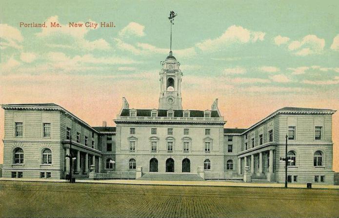
43°39′21″N 70°15′40″W / 43.65583°N 70.26111°WPortland 56 Portland City Hall 
May 7, 1973 389 Congress St.
43°39′34″N 70°15′27″W / 43.65944°N 70.2575°WPortland 57 Portland City Hospital March 21, 1985 Brighton Ave.
43°40′37″N 70°19′31″W / 43.67694°N 70.32528°WPortland 58 Portland Club 
January 25, 1973 156 State St.
43°39′7″N 70°15′58″W / 43.65194°N 70.26611°WPortland 59 Portland High School 
November 23, 1984 284 Cumberland Ave.
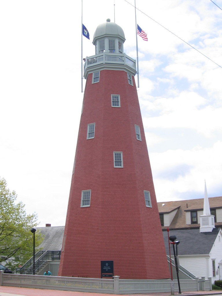
43°39′33″N 70°15′34″W / 43.65917°N 70.25944°WPortland 60 Portland Observatory 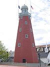
April 24, 1973 138 Congress St.
43°39′56″N 70°14′11″W / 43.66556°N 70.23639°WPortland 61 Portland Packing Company Factory June 7, 1996 14-26 York St.
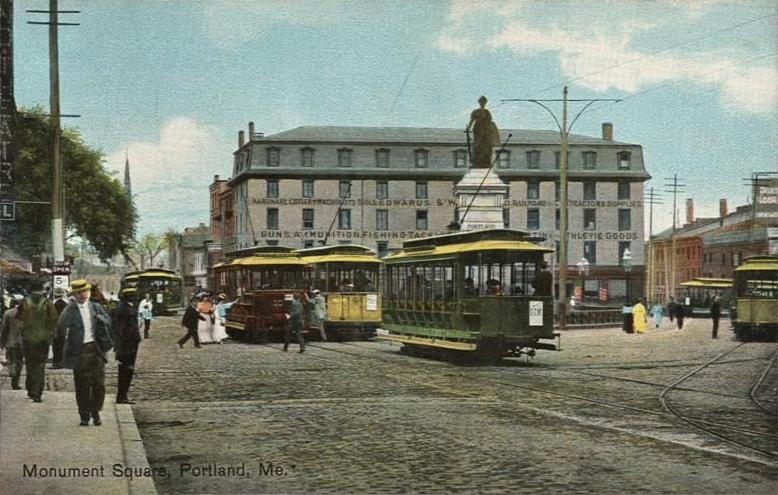
43°39′14″N 70°15′27″W / 43.65389°N 70.2575°WPortland 62 Portland Soldiers and Sailors Monument 
April 1, 1998 Junction of Congress St. and Federal St.
43°39′26″N 70°15′34″W / 43.65722°N 70.25944°WPortland 63 Portland Waterfront May 2, 1974 Waterfront area; also 79-85 and 295-309 Commercial and 3 Center Sts.
43°39′17″N 70°15′37″W / 43.65472°N 70.26028°WPortland Addresses on Commercial and Center Sts. represent a boundary increase 64 Rackleff Building 
May 9, 1973 127, 129, 131, and 133 Middle St.
43°39′31″N 70°15′14″W / 43.65861°N 70.25389°WPortland 65 Thomas Brackett Reed House May 7, 1973 30-32 Deering St.
43°39′15″N 70°16′3″W / 43.65417°N 70.2675°WPortland Home of Thomas Brackett Reed, nineteenth-century Speaker of the United States House of Representatives 66 John B. Russwurm House July 21, 1983 238 Ocean Ave.
43°40′44″N 70°16′49″W / 43.67889°N 70.28028°WPortland Home of John B. Russwurm, abolitionist 67 St. Lawrence Church October 1, 1979 76 Congress St.
43°40′1″N 70°14′48″W / 43.66694°N 70.24667°WPortland 68 St. Paul's Church and Rectory December 22, 1978 279 Congress St.
43°39′43″N 70°15′12″W / 43.66194°N 70.25333°WPortland 69 F.O.J. Smith Tomb December 31, 1974 Stevens Ave. in Evergreen Cemetery
43°40′50″N 70°18′40″W / 43.68056°N 70.31111°WPortland 70 Sparrow House October 29, 1982 35 Arlington St.
43°40′12″N 70°16′58″W / 43.67°N 70.28278°WPortland 71 Spring Street Historic District April 3, 1970 Roughly bounded by Forest, Oak, Danforth, Brackett and Pine Sts.
43°39′8″N 70°15′50″W / 43.65222°N 70.26389°WPortland 72 John Calvin Stevens House 
July 16, 1973 52 Bowdoin St.
43°38′48″N 70°16′30″W / 43.64667°N 70.275°WPortland 73 Stroudwater Historic District February 16, 1973 Residential area at the confluence of the Stroudwater and Fore Rivers
43°39′24″N 70°18′52″W / 43.65667°N 70.31444°WPortland 74 Tate House 
January 12, 1970 1270 Westbrook St.
43°39′25″N 70°18′43″W / 43.65694°N 70.31194°WPortland 75 Thompson Block 
February 28, 1973 117, 119, 121, 123, and 125 Middle St.
43°39′32″N 70°15′11″W / 43.65889°N 70.25306°WPortland 76 Tracy-Causer Block March 17, 1994 505-509 Fore St.
43°39′18″N 70°15′26″W / 43.655°N 70.25722°WPortland 77 U.S. Courthouse 
February 12, 1974 156 Federal St.
43°39′31″N 70°15′42″W / 43.65861°N 70.26167°WPortland 78 U.S. Customhouse 
May 17, 1973 312 Fore St.
43°39′26″N 70°15′5″W / 43.65722°N 70.25139°WPortland 79 US Post Office-Portland Main May 9, 1986 125 Forest Ave.
43°39′30″N 70°16′0″W / 43.65833°N 70.266667°WPortland 80 Wadsworth-Longfellow House 
October 15, 1966 487 Congress St.
43°39′23″N 70°15′40″W / 43.65639°N 70.26111°WPortland 81 Westbrook College Historic District September 15, 1977 716 Stevens Ave.
43°41′0″N 70°17′45″W / 43.683333°N 70.29583°WPortland 82 Western Promenade 
October 16, 1989 Roughly Western Promenade from Maine Medical Center to Valley St.
43°38′48″N 70°16′32″W / 43.64667°N 70.27556°WPortland 83 Western Promenade Historic District 
February 16, 1984 Roughly bounded by Western Promenade and Bramhall, Brackett, Emery, and Danforth Sts.
43°38′54″N 70°16′19″W / 43.64833°N 70.27194°WPortland 84 Williston-West Church and Parish House June 22, 1980 32 Thomas St.
43°38′52″N 70°16′16″W / 43.64778°N 70.27111°WPortland 85 Woodman Building 
February 23, 1972 133-141 Middle St.
43°39′31″N 70°15′15″W / 43.65861°N 70.25417°WPortland Former listing
Landmark name Image Date delisted Location City or Town Summary 1 Portland Stove Foundry January 22, 2009 57 Kennebec St.
43°39′44″N 70°15′40″W / 43.66222°N 70.26111°WPortland Listed on November 18, 1974 See also
References
- ^ The latitude and longitude information provided in this table was derived originally from the National Register Information System, which has been found to be fairly accurate for about 99% of listings. For about 1% of NRIS original coordinates, experience has shown that one or both coordinates are typos or otherwise extremely far off; some corrections may have been made. A more subtle problem causes many locations to be off by up to 150 yards, depending on location in the country: most NRIS coordinates were derived from tracing out latitude and longitudes off of USGS topographical quadrant maps created under North American Datum of 1927, which differs from the current, highly accurate GPS system used by Google maps. Chicago is about right, but NRIS longitudes in Washington are higher by about 4.5 seconds, and are lower by about 2.0 seconds in Maine. Latitudes differ by about 1.0 second in Florida. Some locations in this table may have been corrected to current GPS standards.
- ^ "National Register of Historic Places: Weekly List Actions". National Park Service, United States Department of the Interior. Retrieved on November 10, 2011.
- ^ Numbers represent an ordering by significant words. Various colorings, defined here, differentiate National Historic Landmark sites and National Register of Historic Places Districts from other NRHP buildings, structures, sites or objects.
- ^ "National Register Information System". National Register of Historic Places. National Park Service. 2008-04-24. http://nrhp.focus.nps.gov/natreg/docs/All_Data.html.
U.S. National Register of Historic Places Topics Lists by states Alabama • Alaska • Arizona • Arkansas • California • Colorado • Connecticut • Delaware • Florida • Georgia • Hawaii • Idaho • Illinois • Indiana • Iowa • Kansas • Kentucky • Louisiana • Maine • Maryland • Massachusetts • Michigan • Minnesota • Mississippi • Missouri • Montana • Nebraska • Nevada • New Hampshire • New Jersey • New Mexico • New York • North Carolina • North Dakota • Ohio • Oklahoma • Oregon • Pennsylvania • Rhode Island • South Carolina • South Dakota • Tennessee • Texas • Utah • Vermont • Virginia • Washington • West Virginia • Wisconsin • WyomingLists by territories Lists by associated states Other  Category:National Register of Historic Places •
  Portal:National Register of Historic PlacesCategories:
- National Register of Historic Places in Maine
- History of Portland, Maine
- Buildings and structures in Portland, Maine
-


Wikimedia Foundation. 2010.