- National Register of Historic Places listings in Oklahoma County, Oklahoma
-
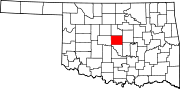
 Location of Oklahoma County in Oklahoma
This is a list of the National Register of Historic Places listings in Oklahoma County, Oklahoma.
This is intended to be a complete list of the properties and districts on the National Register of Historic Places in Oklahoma County, Oklahoma, United States. The locations of National Register properties and districts for which the latitude and longitude coordinates are included below, may be seen in a Google map.[1]
There are 121 properties and districts listed on the National Register in the county. Another property was once listed but has since been removed.
-
- This National Park Service list is complete through NPS recent listings posted November 10, 2011.[2]
Current listings
[3] Landmark name [4] Image Date listed Location City or town Summary 1 "Ringing the Wild Horse" Site January 25, 1971 Northwest of Jones
35°36′07″N 97°20′01″W / 35.601944°N 97.333611°WJones 2 American Legion Hut December 2, 1993 Southwestern corner of the junction of 5th and Little Sts.
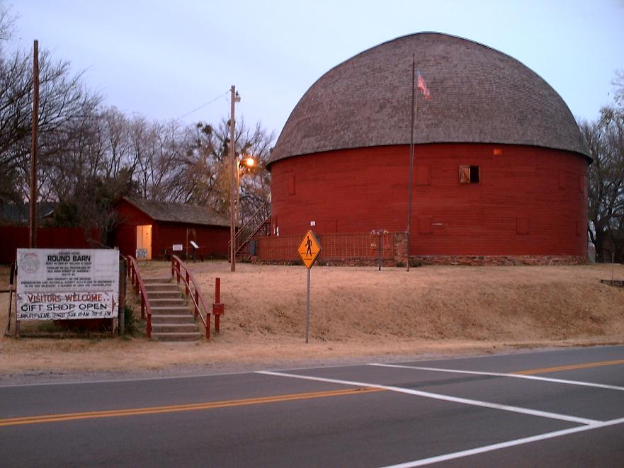
35°39′00″N 97°28′47″W / 35.65°N 97.479722°WEdmond 3 Arcadia Round Barn 
December 23, 1977 Former U.S. Route 66
35°39′44″N 97°19′32″W / 35.662222°N 97.325556°WArcadia 4 Arcadia Route 66 Roadbed November 30, 1999 Extends south-southeast from the junction of State Highway 66 and Hiwassee Rd.
35°39′43″N 97°17′43″W / 35.661944°N 97.295278°WArcadia 5 Automobile Alley Historic District March 18, 1999 Roughly along Broadway Ave., from NW. 4th St. to W. Park Place, and roughly along NW. 10th St.
35°28′33″N 97°30′53″W / 35.475833°N 97.514722°WOklahoma City 6 Avery Building August 12, 1983 15 E. California Ave.
35°27′56″N 97°30′39″W / 35.465556°N 97.510833°WOklahoma City 7 Booher Site (OK48) February 14, 1979 Address Restricted Luther 8 Bourne Dairy October 3, 1979 5801 Eastern St.
35°31′48″N 97°28′37″W / 35.53°N 97.476944°WOklahoma City 9 Braniff Building February 28, 1980 324 N. Robinson St.
35°28′15″N 97°30′57″W / 35.470833°N 97.515833°WOklahoma City 10 Frank and Merle Buttram House and Grounds September 11, 1990 7316 Nichols Rd.
35°33′26″N 97°31′58″W / 35.557222°N 97.532778°WNichols Hills 11 Cain's Coffee Building 
February 4, 1982 1 12th St., NW.
35°28′53″N 97°30′43″W / 35.481389°N 97.511944°WOklahoma City 12 Calvary Baptist Church December 19, 1978 2nd and Walnut Sts.
35°28′11″N 97°30′30″W / 35.469722°N 97.508333°WOklahoma City 13 Capitol-Lincoln Terrace Historic District September 30, 1976 Irregular pattern roughly bounded by 13th, 23rd, Lincoln Boulevard, and Kelley Ave.
35°29′15″N 97°30′02″W / 35.4875°N 97.500556°WOklahoma City 14 Carey Place Historic District October 1, 1998 1800-2100 blocks of Carey Pl.
35°29′21″N 97°32′28″W / 35.489167°N 97.541111°WOklahoma City 15 Cartmill Farm House September 6, 2006 21751 N. Macarthur Boulevard
35°41′33″N 97°37′15″W / 35.6925°N 97.620833°WEdmond 16 J.I. Case Plow Works Building August 12, 1983 2 E. California Ave.
35°27′54″N 97°30′41″W / 35.465°N 97.511389°WOklahoma City 17 Central High School November 7, 1976 700 block of N. Robinson
35°28′32″N 97°30′59″W / 35.475556°N 97.516389°WOklahoma City 18 Citizens Bank Tower 
March 8, 2010 2200 N. Classen Boulevard
35°29′31″N 97°31′50″W / 35.491922°N 97.530561°WOklahoma City Now known as The Classen 19 Citizens State Bank March 13, 1980 102 S. Broadway
35°39′14″N 97°28′51″W / 35.653889°N 97.480833°WEdmond 20 Citizens State Bank 
September 4, 2003 1112 NW. 23rd
35°29′40″N 97°31′51″W / 35.494444°N 97.530833°WOklahoma City 21 Colcord Building 
November 7, 1976 Robinson and Sheridan
35°28′00″N 97°31′00″W / 35.466667°N 97.516667°WOklahoma City 22 Cotton-Exchange Building March 18, 1980 218 N. Harvey St.
35°28′11″N 97°31′03″W / 35.469722°N 97.5175°WOklahoma City 23 Crown Heights Historic District December 28, 1995 Roughly bounded by NW. 36th St., N. Western Ave., NW. 43rd St., and N. Walker Ave.
35°30′41″N 97°31′31″W / 35.511389°N 97.525278°WOklahoma City 24 Douglas DC-3 Airplane, N34 May 29, 1997 6500 S. MacArthur Boulevard, Hangar 10
35°23′50″N 97°36′52″W / 35.397222°N 97.614444°WOklahoma City 25 Old Douglass High School April 4, 2007 600 N. High Ave.
35°28′31″N 97°29′38″W / 35.475278°N 97.493889°WOklahoma City 26 Edgemere Park Historic District November 12, 1980 Roughly bounded by Robinson and Walker and NW. 30 and NW. 36
35°30′12″N 97°31′02″W / 35.503333°N 97.517222°WOklahoma City 27 Edmond Armory March 14, 1991 431 S. Boulevard
35°39′00″N 97°28′41″W / 35.65°N 97.478056°WEdmond 28 Edwards Heights Historic District September 7, 2005 Roughly bounded by NE. 16th St., N. Page Ave., NE. Success St. and N. Bryant Ave., extension on NE. Grand Boulevard
35°29′18″N 97°27′52″W / 35.488333°N 97.464444°WOklahoma City 29 Edwards Historic District October 3, 1996 Roughly bounded by N. Page Ave., NE. 16th St., NE. Grand Boulevard, and E. Park Pl.
35°29′00″N 97°27′59″W / 35.483333°N 97.466389°WOklahoma City 30 Walter J. and Frances W. Edwards House September 8, 1994 1621 NE. Grand Boulevard
35°29′08″N 97°27′56″W / 35.485556°N 97.465556°WOklahoma City 31 Elks Lodge Building March 10, 1980 401 N. Harvey St.
35°28′16″N 97°31′10″W / 35.471111°N 97.519444°WOklahoma City 32 Elks Victory Lodge-Ruby's Grill Building January 11, 1996 322 NE. 2nd
35°28′10″N 97°30′22″W / 35.469444°N 97.506111°WOklahoma City 33 Engels' Dry Goods Store March 3, 1980 114 S. Main St.
35°39′42″N 97°11′43″W / 35.661667°N 97.195278°WLuther 34 Fairchild Winery March 13, 1975 1600 81st St., NE.
35°33′16″N 97°29′10″W / 35.554444°N 97.486111°WOklahoma City 35 Farmers Public Market December 2, 1982 311 S. Klein St.
35°27′46″N 97°31′59″W / 35.462778°N 97.533056°WOklahoma City 36 Fidelity National Building March 6, 2008 200 N. Harvey Ave.
35°28′15″N 97°31′04″W / 35.470833°N 97.517778°WOklahoma City 37 Film Exchange Historic District September 6, 2007 Junction of W. Sheridan Ave. and Lee Ave.
35°27′59″N 97°31′26″W / 35.466389°N 97.523889°WOklahoma City 38 First Christian Church March 8, 1984 1104 N. Robinson Ave.
35°28′43″N 97°31′35″W / 35.478611°N 97.526389°WOklahoma City 39 First Christian Church Historic District March 14, 2011 3700 N. Walker Ave.
35°30′33″N 97°31′06″W / 35.509167°N 97.518333°WOklahoma City 40 First Church of Christ, Scientist September 9, 2001 1200 N. Robinson Ave.
35°29′07″N 97°31′09″W / 35.485278°N 97.519167°WOklahoma City 41 Gatewood East Historic District March 3, 2004 NW. 16th to north of NW. 22nd, N. Classen Boulevard to N. Blackwelder Ave., and N. Florida Ave.
35°29′17″N 97°32′09″W / 35.488056°N 97.535833°WOklahoma City 42 Gatewood West Historic District March 3, 2004 NW. 16th to NW. 23rd, N. Blackwelder Ave. and N. Florida Ave. to Pennsylvania Ave.
35°29′22″N 97°32′36″W / 35.489444°N 97.543333°WOklahoma City 43 Goodholm House March 30, 1983 3101 W. Gen. Pershing Boulevard
35°28′29″N 97°34′11″W / 35.474722°N 97.569722°WOklahoma City 44 Gower Cemetery December 27, 1991 Covel Rd. between Douglas and Post Rds.
35°40′53″N 97°21′37″W / 35.681389°N 97.360278°WEdmond 45 W.T. Hales House March 29, 1978 1521 N. Hudson Ave.
35°29′09″N 97°31′09″W / 35.485833°N 97.519167°WOklahoma City 46 Harbour-Longmire Building March 3, 1980 420 W. Main St.
35°28′03″N 97°31′12″W / 35.4675°N 97.52°WOklahoma City 47 Harding Junior High School March 13, 2002 3333 N. Shartel Ave.
35°30′32″N 97°31′33″W / 35.508889°N 97.525833°WOklahoma City 48 Harn House April 13, 1973 NE. 17th St. and Stiles
35°29′11″N 97°30′24″W / 35.486389°N 97.506667°WOklahoma City 49 Haywood Building January 11, 1996 307 NE. 2nd
35°28′11″N 97°30′25″W / 35.469722°N 97.506944°WOklahoma City 50 Heierding Building March 10, 1982 35 Harrison Ave.
35°28′21″N 97°30′39″W / 35.4725°N 97.510833°WOklahoma City 51 Heritage Hills Historic and Architectural District June 4, 1979 Roughly bounded by Robinson and Walker Aves., 14th, 15th, and 21st Sts., and Classen Boulevard
35°29′12″N 97°31′20″W / 35.486667°N 97.522222°WOklahoma City 52 Hightower Building March 13, 2002 105 N. Hudson
35°28′11″N 97°31′11″W / 35.469722°N 97.519722°WOklahoma City 53 Hopewell Baptist Church September 14, 2002 5801 NW. 178th St.
35°39′11″N 97°37′13″W / 35.653056°N 97.620278°WEdmond 54 India Temple Shrine Building 
March 26, 1980 621 N. Robinson Ave.
35°28′25″N 97°30′58″W / 35.473611°N 97.516111°WOklahoma City Also known as the Journal Record Building. Built by Freemasons in 1923; later used for offices; damaged in the 1995 Oklahoma City bombing; now houses the Oklahoma City National Memorial Museum. 55 Jefferson Park Historic District December 14, 1995 Roughly bounded by NW. 23rd St., N. Walker Ave., NW. 30th St., and Interstate 235
35°29′49″N 97°31′03″W / 35.496944°N 97.5175°WOklahoma City 56 Jewel Theater September 3, 2009 904 NE 4th St.
35°28′16″N 97°29′49″W / 35.471217°N 97.497017°WOklahoma City 57 Charles G. Jones Farmstead June 14, 2001 12061 NE 108th St.
35°34′52″N 97°18′34″W / 35.581111°N 97.309444°WJones 58 Kaiser's Ice Cream Parlour November 28, 1978 1039 N. Walker Ave.
35°28′43″N 97°31′16″W / 35.478611°N 97.521111°WOklahoma City 59 Kingman-More Building August 12, 1983 100 E. California Ave.
35°27′54″N 97°30′36″W / 35.465°N 97.51°WOklahoma City 60 Kivlehen House December 4, 2008 525 N. Jackson St.
35°39′39″N 97°28′37″W / 35.660761°N 97.476872°WEdmond 61 Lake Overholser Bridge March 2, 2004 N. Overholser Dr., 0.5 miles west of N. Council Rd.
35°30′51″N 97°37′49″W / 35.514167°N 97.630278°WOklahoma City 62 Lake Overholser Dam June 5, 2007 NW. 16th St. and E. Lake Overholser Dr.
35°29′10″N 97°39′54″W / 35.486111°N 97.665°WOklahoma City 63 Lincoln Terrace East Historic District March 3, 2004 Roughly bounded by Kelley Ave, NE. 16th St., Philips Ave., NE. 14th St., Linday Ave., Culbertston Dr., and NE. 21st St.
35°29′15″N 97°29′49″W / 35.4875°N 97.496944°WOklahoma City 64 Littlepage Building January 11, 1996 219 N. Central Ave.
35°28′10″N 97°30′27″W / 35.469444°N 97.5075°WOklahoma City 65 Melvin F. Luster House June 7, 1983 300 3rd St., NE.
35°28′14″N 97°30′25″W / 35.470556°N 97.506944°WOklahoma City 66 Magnolia Petroleum Building October 4, 1979 722 N. Broadway St.
35°28′29″N 97°30′49″W / 35.474722°N 97.513611°WOklahoma City 67 Main Public Library December 13, 2010 131 Dean McGee Ave.
35°28′16″N 97°30′58″W / 35.471111°N 97.516111°WOklahoma City 68 Maney Historic District July 18, 1979 725 NW. 11th St. and 1200 and 1224 N. Shartel Ave.
35°28′49″N 97°31′30″W / 35.480278°N 97.525°WOklahoma City 69 Merchants Transfer and Storage April 2, 1999 19 E. California
35°27′56″N 97°30′38″W / 35.465556°N 97.510556°WOklahoma City 70 Mesta Park July 26, 1983 Roughly bounded by NW. 16th and 23rd Sts. and Western and Walker Aves.
35°29′21″N 97°31′25″W / 35.489167°N 97.523611°WOklahoma City 71 Mid-Continent Life Building March 12, 1979 1400 Classen Dr.
35°29′00″N 97°31′33″W / 35.483333°N 97.525833°WOklahoma City 72 Mideke Supply Building August 12, 1983 100 E. Main St.
35°28′02″N 97°30′35″W / 35.467222°N 97.509722°WOklahoma City 73 Milk Bottle Grocery March 5, 1998 2426 N. Classen Boulevard
35°29′39″N 97°31′55″W / 35.494167°N 97.531944°WOklahoma City 74 Miller-Jackson Building August 12, 1983 121 E. California Ave.
35°27′56″N 97°30′34″W / 35.465556°N 97.509444°WOklahoma City 75 Nagle Site February 14, 1979 Address Restricted Spencer 76 Norton-Johnson Buick Company June 22, 1998 117-125 NW. 13th St.
35°28′58″N 97°30′53″W / 35.482778°N 97.514722°WOklahoma City 77 Oklahoma City Discovery Well December 9, 1977 SE. 57th St. and ITIO Boulevard
35°24′29″N 97°27′40″W / 35.408056°N 97.461111°WOklahoma City 78 Oklahoma City Municipal Building 
June 5, 2007 200 N. Walker Ave.
35°28′08″N 97°31′13″W / 35.468889°N 97.520278°WOklahoma City 79 Oklahoma City National Memorial 
October 9, 1997 Bounded by NW. 6th St., N. Robinson Ave., NW. 4th St., and N. Harvey Ave.
35°28′22″N 97°31′02″W / 35.472778°N 97.517222°WOklahoma City 80 Oklahoma City University December 19, 1978 2501 N. Blackwelder Ave.
35°29′42″N 97°32′39″W / 35.494983°N 97.544106°WOklahoma City 81 Oklahoma County Courthouse March 5, 1992 321 Park Ave.
35°28′08″N 97°31′14″W / 35.468889°N 97.520556°WOklahoma City 82 Oklahoma County Home for Girls March 21, 1978 6300 N. Western Ave.
35°32′09″N 97°31′43″W / 35.535833°N 97.528611°WOklahoma City 83 Oklahoma Gas and Electric Company Building April 9, 1980 321 N. Harvey Ave.
35°28′15″N 97°31′09″W / 35.470833°N 97.519167°WOklahoma City 84 Oklahoma Hardware Building August 12, 1983 27 E. California Ave.
35°27′56″N 97°30′38″W / 35.465556°N 97.510556°WOklahoma City 85 Oklahoma Historical Society Building 
February 21, 1990 2100 Lincoln Boulevard
35°29′24″N 97°30′07″W / 35.49°N 97.501944°WOklahoma City 86 Oklahoma Publishing Company Building September 18, 1978 500 N. Broadway
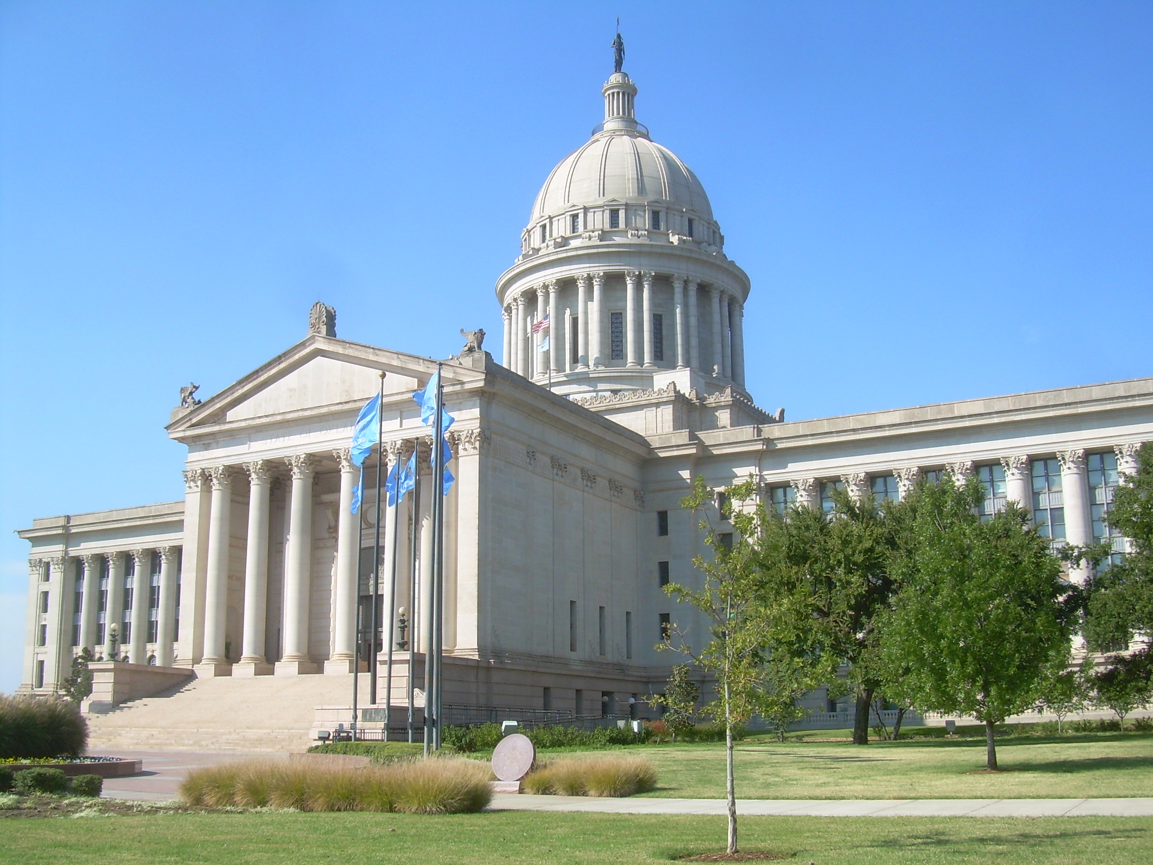
35°28′19″N 97°30′50″W / 35.471944°N 97.513889°WOklahoma City 87 Oklahoma State Capitol 
October 8, 1976 22nd St. and Lincoln Boulevard
35°29′32″N 97°30′11″W / 35.492222°N 97.503056°WOklahoma City 88 Old North Tower, Central State College June 21, 1971 400 E. Hurd St. on the Central State College campus
35°39′21″N 97°28′25″W / 35.655833°N 97.473611°WEdmond 89 Overholser House June 22, 1970 405 15th St., NW.
35°29′06″N 97°30′45″W / 35.485°N 97.5125°WOklahoma City 90 Paseo Neighborhood Historic District May 27, 2004 Roughly by NW. 30th St., North Western Ave., NW. 24th St., and N. Walker Ave.
35°29′58″N 97°31′31″W / 35.499444°N 97.525278°WOklahoma City 91 Pilgrim Congregational Church February 23, 1984 1433 Classen Dr.
35°28′58″N 97°31′36″W / 35.482778°N 97.526667°WOklahoma City 92 Pioneer Building March 3, 1980 401 N. Broadway St.
35°28′16″N 97°30′51″W / 35.471111°N 97.514167°WOklahoma City 93 Plaza Court September 8, 1980 1100 Classen Dr.
35°28′46″N 97°31′16″W / 35.479444°N 97.521111°WOklahoma City 94 Point 8 Site September 6, 1978 Address Restricted Oklahoma City 95 Donald Pollock House December 13, 2001 2400 NW. 59th St.
35°32′07″N 97°33′13″W / 35.535278°N 97.553611°WOklahoma City 96 Post Office, Courthouse, and Federal Office Building 
August 30, 1974 Robinson at 3rd St.
35°28′16″N 97°31′01″W / 35.471111°N 97.516944°WOklahoma City 97 Putnam Heights Historic Preservation District June 2, 1982 Georgia and McKinley Boulevards and 35th, 37th, and 38th Sts.
35°30′28″N 97°32′12″W / 35.507778°N 97.536667°WOklahoma City 98 Quillin Site February 14, 1979 Address Restricted Midwest City 99 Rock Island Plow Building August 12, 1983 29 E. Reno Ave.
35°27′52″N 97°30′38″W / 35.464444°N 97.510556°WOklahoma City 100 St. Joseph's Cathedral January 30, 1978 225 4th St., NW.
35°28′20″N 97°31′05″W / 35.472222°N 97.518056°WOklahoma City 101 St. Paul's Cathedral April 11, 1977 127 7th St., NW.
35°28′31″N 97°30′56″W / 35.475278°N 97.515556°WOklahoma City 102 Shepherd Historic District June 20, 1997 Roughly bounded by NW. 30th and NW. 25th Sts., N. Pennsylvania Ave., and N. Youngs Boulevard
35°29′55″N 97°33′05″W / 35.498611°N 97.551389°WOklahoma City 103 Sherman Machine and Iron Works Building August 12, 1983 26 E. Main St.
35°28′03″N 97°30′38″W / 35.4675°N 97.510556°WOklahoma City 104 Sieber Grocery and Apartment Hotel September 7, 2005 1305-1313 N. Hudson Ave.
35°29′01″N 97°30′58″W / 35.483611°N 97.516111°WOklahoma City 105 John Sinopoulo House November 28, 1978 4000 N. Kelley
35°30′41″N 97°29′34″W / 35.511389°N 97.492778°WOklahoma City 106 Skirvin Hotel 
October 10, 1979 1 Park Ave.
35°28′08″N 97°30′49″W / 35.468889°N 97.513611°WOklahoma City 107 Smith and Kernke Funeral Directors June 3, 1999 1401 NW. 23rd St.
35°29′37″N 97°32′05″W / 35.493611°N 97.534722°WOklahoma City 108 Spanish Village Historic District February 24, 1983 2909-3024 Paseo
35°29′57″N 97°31′19″W / 35.499167°N 97.521944°WOklahoma City 109 Spencer No. 2 Site November 27, 1978 Address Restricted Oklahoma City 110 Stanford Furniture Co. Building August 12, 1983 1 E. Sheridan Ave.
35°28′00″N 97°30′41″W / 35.466667°N 97.511389°WOklahoma City 111 Stockyards City Historic District August 24, 1979 An irregular pattern along Agnew and Exchange Aves.
35°27′11″N 97°33′22″W / 35.453056°N 97.556111°WOklahoma City 112 Taft Junior High School June 5, 2007 2901 NW. 23rd. St.
35°29′38″N 97°33′58″W / 35.493889°N 97.566111°WOklahoma City 113 The "Y" Chapel of Song June 14, 2001 100 N. University; on the campus of the University of Central Oklahoma
35°39′19″N 97°28′23″W / 35.655278°N 97.473056°WEdmond 114 Threatt Filling Station February 23, 1995 Southwestern corner of the former U.S. Route 66 and Pottawatomi Rd.
35°39′59″N 97°08′28″W / 35.666389°N 97.141111°WLuther 115 Tradesman's National Bank Building November 5, 1980 101 N. Broadway St.
35°28′04″N 97°30′52″W / 35.467778°N 97.514444°WOklahoma City 116 Tuton's Drugstore March 3, 1980 1st and Main Sts.
35°39′47″N 97°19′30″W / 35.663056°N 97.325°WArcadia 117 Union Depot May 16, 1978 300 7th St., NW.
35°27′26″N 97°31′06″W / 35.457222°N 97.518333°WOklahoma City 118 Walcourt Building March 19, 1982 1401 Walnut Ave., NE.
35°28′58″N 97°30′32″W / 35.482778°N 97.508889°WOklahoma City 119 Weather Service Building July 12, 1978 1923 Classen Boulevard
35°29′24″N 97°31′53″W / 35.49°N 97.531389°WOklahoma City 120 Wells Fargo and Company Livery Stable July 9, 1982 115 E. Reno Ave.
35°27′52″N 97°30′34″W / 35.464444°N 97.509444°WOklahoma City 121 Will Rogers Park Gardens and Arboretum September 7, 2005 3400-3500 NW. 36th St.
35°30′30″N 97°34′46″W / 35.508333°N 97.579444°WOklahoma City Former listing
Landmark name Image Dates Location City or Town Summary 1 Montgomery Ward Building March 8, 2005 (delisted) Oklahoma City See also
- List of National Historic Landmarks in Oklahoma
- National Register of Historic Places listings in Oklahoma
References
- ^ The latitude and longitude information provided in this table was derived originally from the National Register Information System, which has been found to be fairly accurate for about 99% of listings. For about 1% of NRIS original coordinates, experience has shown that one or both coordinates are typos or otherwise extremely far off; some corrections may have been made. A more subtle problem causes many locations to be off by up to 150 yards, depending on location in the country: most NRIS coordinates were derived from tracing out latitude and longitudes off of USGS topographical quadrant maps created under the North American Datum of 1927, which differs from the current, highly accurate WGS84 GPS system used by Google maps. Chicago is about right, but NRIS longitudes in Washington are higher by about 4.5 seconds, and are lower by about 2.0 seconds in Maine. Latitudes differ by about 1.0 second in Florida. Some locations in this table may have been corrected to current GPS standards.
- ^ "National Register of Historic Places: Weekly List Actions". National Park Service, United States Department of the Interior. Retrieved on November 10, 2011.
- ^ Numbers represent an ordering by significant words. Various colorings, defined here, differentiate National Historic Landmark sites and National Register of Historic Places Districts from other NRHP buildings, structures, sites or objects.
- ^ "National Register Information System". National Register of Historic Places. National Park Service. . http://nrhp.focus.nps.gov/natreg/docs/All_Data.html.
U.S. National Register of Historic Places Topics Lists by states Alabama • Alaska • Arizona • Arkansas • California • Colorado • Connecticut • Delaware • Florida • Georgia • Hawaii • Idaho • Illinois • Indiana • Iowa • Kansas • Kentucky • Louisiana • Maine • Maryland • Massachusetts • Michigan • Minnesota • Mississippi • Missouri • Montana • Nebraska • Nevada • New Hampshire • New Jersey • New Mexico • New York • North Carolina • North Dakota • Ohio • Oklahoma • Oregon • Pennsylvania • Rhode Island • South Carolina • South Dakota • Tennessee • Texas • Utah • Vermont • Virginia • Washington • West Virginia • Wisconsin • WyomingLists by territories Lists by associated states Other Municipalities and communities of Oklahoma County, Oklahoma Cities Bethany | Choctaw | Del City | Edmond | Harrah | Midwest City | Nichols Hills | Nicoma Park | Oklahoma City‡ | Spencer | The Village | Warr Acres
Towns Arcadia | Forest Park | Jones | Lake Aluma | Luther | Smith Village | Valley Brook | Woodlawn Park
Unincorporated
communitiesLake Hiawasse | Newalla | Woods
Footnotes ‡This populated place also has portions in an adjacent county or counties
Categories:- Buildings and structures in Oklahoma City
- National Register of Historic Places in Oklahoma by county
-


Wikimedia Foundation. 2010.