- Narsarsuaq Air Base
-
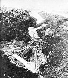 Bluie West One, June 1942
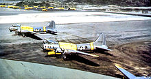 51st Rescue Squadron SB-17s, Narsarsuaq Air Base about 1952
- For the civil use of the facility after 1958, see: Narsarsuaq Airport
Bluie West One airfield was built on a glacial moraine at what is now the village of Narsarsuaq, near the southern tip of Greenland. Construction by the U.S. Army began in June 1941, and the first plane landed there in January 1942. As a link in the North Atlantic Ferry Route during World War II, it had a peak population of about 4,000 American servicemen, and it is estimated that some 10,000 aircraft landed there en route to the war in Europe and North Africa.
Soon after the United States entered the war, the War Department decided to deploy Major General Carl Spaatz's Eighth Air Force to Britain. This put the North Atlantic facilities constructed by the Corps to an early test.
Radioing from Bluie West 1 in Greenland while crossing the Atlantic in mid-June 1942, Spaatz ordered the movement to begin. The P-38 and P-39 fighters, piloted by combat crews that had been given special training in long-distance flying, were escorted by the longer-range B-17 bombers.
With stops at the Canadian-built base at Goose Bay in Labrador, Bluie West 1 in southern Greenland, and Reykjavik or Keflavik in Iceland, the planes could fly from the new Presque Isle field in northern Maine to Prestwick Field in Scotland with no leg of the journey longer than 850 miles
Other important bases in Greenland were Bluie West Eight near the present-day town of Kangerlussuaq, and Bluie East One on the almost-uninhabited east coast.
Bad weather is frequent in southern Greenland, and Narsarsuaq is virtually surrounded by high mountains, making the approach to the steel-mat runway exceedingly difficult. The usual approach was a low-level flight up a fjord. Landings were (and still are predominantly) made to the east, with takeoffs to the west, regardless of the wind direction.
BW-1's importance declined postwar, but the U.S. Air Force maintained it as Narsarsuaq Air Base during the early Cold War years, when it served as a refueling station for jet fighters and for helicopters crossing the North Atlantic. The runway by this time had been paved with concrete. Jets require a longer takeoff run than do propeller-driven aircraft, and the air base used a small tugboat to move icebergs out of the way of planes taking off over the basin west of the runway.
The advent of aerial refueling, and the opening of the larger Thule Air Base in northern Greenland, made the base redundant, and it was turned over to the Danish government of Greenland in 1958. Today it is Narsarsuaq Airport and served by regular flights from Reykjavík, Iceland during the summer season, as well as by commuter aircraft from Kangerlussaq and other Greenlandic airfields. The airport is designated UAK, and the runway headings are 07 for landing and 25 for takeoff (070 and 250 degrees magnetic). There is no control tower, and a 4,000-foot ceiling is advised even for an approach on instruments.
See also
References
 This article incorporates public domain material from websites or documents of the Air Force Historical Research Agency.
External links
Categories:- Airports in Greenland
- USAAF Air Transport Command Airfields - North Atlantic Route
- Airfields of the United States Army Air Forces in Greenland


Wikimedia Foundation. 2010.