- Nain province
-
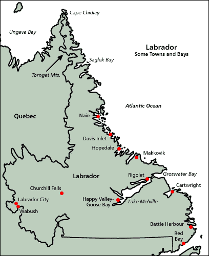
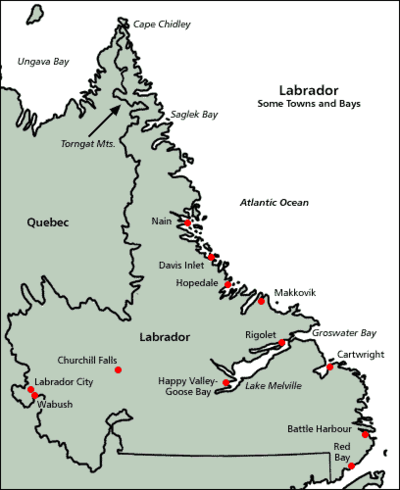 Note Saglek Bay, Nain and Hopedale
In Labrador, Canada, the North Atlantic craton is known as the Nain province. The Nain geologic province was intruded by the Nain Plutonic Suite which divides the province into the northern Saglek block and the southern Hopedale block.[1]
Contents
North Atlantic craton
The North Atlantic craton is exposed in parts of the coast of Labrador, parts of central Greenland, the Scourian Complex of northwestern Scotland and is unexposed in northern Norway. The North Atlantic craton fragmented 2450 to 2000 million years ago.[2]:847 When North America and Europe rejoined, the North Atlantic craton was triangular shaped with each side 600 km (370 mi); this unit was separated when the Labrador Sea formed 61 to 40 million years ago. The North Atlantic craton's crust varies between 28 to 38 km (17 to 24 mi) thick[3]:673 and its rocks are 85% granitoid gneisses. The Nain province was intruded by the 1350- to 1290-million-year-old Nain Plutonic Suite;[3]:673 composite anorthosite-granitic intrusions which divide the Nain province into the northern Saglek block and the southern Hopedale block.[1]
Nain province
In Labrador the North Atlantic craton is known as the Nain province or Nain craton. The Nain province is more than 600 kilometres (370 mi) long and 100 km (62 mi) wide.[1] The gneisses of the Nain province were last deformed and metamorphosed[4]:1245 when two blocks docked together 2500 million years ago[5] with a collisional boundary extending 200 km (120 mi) to the north and 150 km (93 mi) to the south of Nain, Labrador, Canada.[6] These two blocks appear to represent two distinct Archean cratonic nuclei, each with its own mineral depositional history.[1]
Major granitic intrusions – the Wheeler Mountain, Halbach, Alliger, Sheet Hill, Loon Island, Red Island, and Satok Island intrusions – form a north-trending 150 km (93 mi) linear chain which have a southerly decrease in age – 2135-million-year-old Wheeler Mountain granite in the north to the 2025-million-year-old Satok Island monzonite in the south.[2]:847,848 The Nain province was then intruded by the 1350- to 1290-million-year-old Nain Plutonic Suite;[3]:673 composite anorthosite-granitic intrusions which divide the Nain province into the northern Saglek block and the southern Hopedale block.[1] The Torngat orogen developed during the oblique convergence of the Superior and Nain provinces[7]:23,403 900 million years ago.
The crystalline crust in the Nain province is 38 km (24 mi) thick; it thins to 9 km (5.6 mi) thick in the shelf area of the Labrador margin, where it is covered with up to 8 km (5.0 mi) of sediments.[8]
Saglek block
The 3800- to 3300-million-year-old Saglek block[5] is 375 km (233 mi) long and 50 km (31 mi) wide;[1] it has a north-northwesterly trend from Nain, Labrador, extending nearly to the northern tip of Labrador. This block is a high-grade gneiss terrane; it has no greenstone belts.[1] Within the gneiss are variably-sized enclaves ranging from anorthosite to ultramafic.[1] There are also three small anorthositic, ultramafic meta-igneous complexes in the gneiss near Okak Bay.[1]
The northward–trending Handy fault separates the Saglek block into two metamorphic parts.[3]:673 The gneiss complex on the western side of the Handy fault has rocks that crystallized under granulite facies conditions; this western block is more deeply exposed than the eastern one.[3]:681 On the eastern side amphibolite facies rocks are exposed in the northern part; they transition to granulite facies to the south.[3]:673 The total crustal thickness is 33 km (21 mi) north of the fault and 38 km (24 mi) south of the fault.[9]
Hopedale block
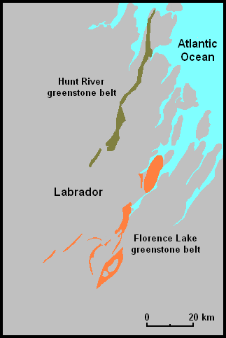
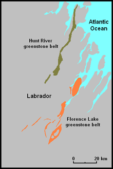 Hunt River and Florence Lake greenstone belts
The 3100- to 2800-million-year-old Hopedale block[5] is 150 km (93 mi) long and 90 km (56 mi) wide.[1] Hopedale, Labrador, is at the eastern midpoint. This block contains the 3100-million-year-old[10] Hunt River and 3000-million-year-old Florence Lake greenstone belts, and the Weekes amphibolite which represents remnants of the older Hunt River greenstone belt.[1]
References
- ^ a b c d e f g h i j k Wilton, D. H. C. (1996). "Metallogenic Overview of the Nain Province, Northern Labrador". CIM Bulletin (Canadian Institute of Mining, Metallurgy and Petroleum, Montréal, PQ, Canada) 89 (99): 43. ISSN 0317-0926. http://cat.inist.fr/?aModele=afficheN&cpsidt=3008102. Retrieved June 24, 2010.
- ^ a b Connelly, James N.; Ryan, A. Bruce (1999). "Age and Tectonic Implications of Paleoproterozoic Granitoid Intrusions Within the Nain Province near Nain, Labrador". Canadian Journal of Earth Sciences 36 (5): 833–853. http://article.pubs.nrc-cnrc.gc.ca/ppv/RPViewDoc?issn=1480-3313&volume=36&issue=5&startPage=833. Retrieved June 13, 2010.
- ^ a b c d e f Funck, Thomas Funck; Louden, Keith E. (1998). "Wide-Angle Seismic Imaging of Pristine Archean Crust in the Nain Province, Labrador". Canadian Journal of Earth Sciences 35 (6): 672–685. doi:10.1139/cjes-35-6-672. http://article.pubs.nrc-cnrc.gc.ca/ppv/RPViewDoc?issn=1480-3313&volume=35&issue=6&startPage=672. Retrieved June 13, 2010.
- ^ Culshaw, N.; Brown, T.; Reynolds, P.H.; Ketchum, J.W.F. (2000). "Kanairiktok Shear Zone: The Boundary Between the Paleoproterozoic Makkovik Province and the Archean Nain Province, Labrador, Canada". Canadian Journal of Earth Sciences 37 (9): 1245–1257. http://article.pubs.nrc-cnrc.gc.ca/ppv/RPViewDoc?issn=1480-3313&volume=37&issue=9&startPage=1245. Retrieved June 12, 2010.
- ^ a b c Mareschal, J.C.; Poirier, A.; Bienfait, G.; Gariepy, C.; Lapointe, R.; Jaupart, C. (March 15, 2000). "Low mantle heat flow at the edge of the North American continent, Voisey Bay, Labrador". Geophysical Research Letters 27 (6): 823. Bibcode 2000GeoRL..27..823M. doi:10.1029/1999GL011069. http://www.unites.uqam.ca?geotop/geophysique/ARTICLES/1999GL011069.pdf. Retrieved June 12, 2010.
- ^ Connelly, J.N.; Ryan, B. (1996). 13, 2010 "Late Archean evolution of the Nain Province, Nain, Labrador: imprint of a collision". Canadian Journal of Earth Sciences 33 (9): 1325. doi:10.1139/e96-100. http://rparticle.web-p.cisti.nrc.ca/rparticle/AbstractTemplateServlet?journal=cjes&volume=33&year=1996&issue=9&msno=e96-100&calyLang=fra?accessdate=June 13, 2010.
- ^ Funck, Thomas; Louden, Keith E.; Wardle, Richard J.; Hall, Jeremy; Hobro, James W.; Salisbury, Matthew H.; Muzzatti, Angelina M. (2000). "Three-Dimensional Structure of the Torngat Orogen (NE Canada) from Active Seismic Tomography". Journal of Geophysical Research 105 (B10): 23,403–23,420. Bibcode 2000JGR...10523403F. doi:10.1029/2000JB900228. http://www.agu.org/pubs/crossref/2000/2000JB900228.shtml. Retrieved June 13, 2010.
- ^ Funck, Thomas; Louden, Keith E.. "Wide-angle Seismic Transect Across the Torngat Orogen, Northern Labrador: Evidence for a Proterozoic Crustal Root". Journal of Geophysical Research 104(B4): 7463. http://europa.agu.org/?uri=/journals/jb/1999JB900010.xml&view=article. Retrieved June 13, 2010.
- ^ Funck, Thomas; Louden, Keith E. (1998). "Wide-Angle Seismic Imaging of Pristine Archean Crust in the Nain Province, Labrador". Canadian Journal of Earth Sciences 35 (6): 672. doi:10.1139/cjes-35-6-672. http://rparticle.web-p.cisti.nrc.ca/rparticle/AbstractTemplateServlet?calyLang=eng&journal=cjes&volume=35&year=1998&issue-6&msno=e98-019. Retrieved June 20, 2010.
- ^ James, D.T.; Kamo, S.; Krogh, T. (2002). "Evolution of 3.1 and 3.0 Ga Volcanic Belts and a New Thermotectonic Model for the Hopedale Block, North Atlantic Craton (Canada)". Canadian Journal of Earth Sciences 39 (5): 687. doi:10.1139/e01-092. http://rparticle.web-p.cisti.nrc.ca/rparticle/AbstractTemplateServlet?calyLang=eng&journal=cjes&volume=39&year=2002&issue=5&msno=e01-092. Retrieved June 30, 2010.
Categories:- Geologic provinces
- Geologic provinces of Canada
- Geological history of Earth
- Historical tectonic plates
- Cratons
- Greenstone belts
- Geology of Newfoundland and Labrador
- Labrador
- Volcanism of Newfoundland and Labrador
Wikimedia Foundation. 2010.