- North Carolina Department of Transportation Ferry Division
-
NCDOT Ferry Division 
Number of ferries: 24 Regular Routes: -Currituck to Knott's Island
-Hatteras to Ocracoke
-Swan Quarter to Ocracoke
-Cedar Island to Ocracoke
-Bayview to Aurora
-Cherry Branch to Minnesott Beach
-Southport to Fort FisherEmergency Route: -Stumpy Point to Rodanthe The North Carolina Department of Transportation Ferry Division is a branch of NCDOT that is responsible for the operation of over two dozen ferry services that transport passengers and vehicles to several islands along the Outer Banks of North Carolina.
Three other inland, cable ferries — the Elwell Ferry, Parker's Ferry and Sans Souci Ferry — continue in operation, under the oversight of the North Carolina Department of Transportation.
Contents
History
Ferries have always played a vital role to the residents and visitors of Eastern North Carolina. The first ferries began in the mid-1920s when Captain J.B.(Toby)Tillett established a tug and barge service across Oregon Inlet along North Carolina's Outer Banks.
In 1934, the North Carolina Highway Commission recognized the importance of this service to residents and began subsidizing Tillett's business. These subsidies kept tolls at an affordable level. In 1942, the Highway Commission began full reimbursement to eliminate the tolls. Tillett was fully subsidized until 1950 when his business was sold to the state.
In 1947, the Commission purchased the ferry operations of T.A. Baum, who operated a route that ran across Croatan Sound and linked Manns Harbor and Roanoke Island. This became the first route of the N.C. Ferry System.
 The logo of the North Carolina Ferry System that appears on all the vessels beneath the name of the vessel on the tower.
Today
The North Carolina Department of Transportation's Ferry Division extends over seven routes, one emergency route, has 24 ferries and employs over 400 workers. The operations are supported by a full service shipyard, dredge, military-style landing craft utility vehicles (LCU's), tugs, barges, and other support vessels.
Each year, North Carolina ferries transport over 1.1 million vehicles and more than 2.5 million passengers across five separate bodies of water - the Currituck and Pamlico sounds and the Cape Fear, Neuse and Pamlico rivers.
Ferries also carry essential goods to water-locked communities. Many residents depend on the ferries for transportation to school, work, and other needed services.
Types of ferry boats
Hatteras Class
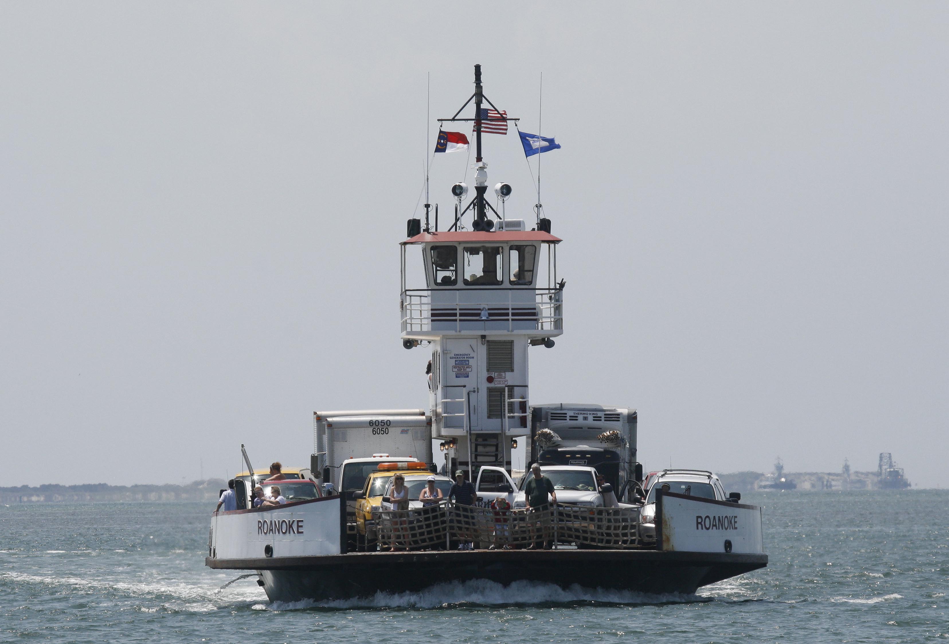
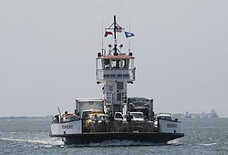 The Hatteras Class ferry, Roanoke, operating between Cherry Branch and Minnesott Beach on the Neuse River.
The North Carolina Ferry System operates several Hatteras Class ferries. These Vessels draft less than 4 feet, and are designed for the shallow waters and shifting shoals of Eastern North Carolina. The Thomas A. Baum was built at the Steiner Shipyards in Bayou La Batre, AL and was delivered to the North Carolina Department of Transportation on June 13, 1995. It is powered by two Detroit Diesel 12V71 DDECs each rated at 500 HP.
Ferry Name Conrad Wirth Ocracoke Bonner Chicamacomico Cape Point Kinnakeet Frisco Roanoke Thomas A. Baum Vehicle Capacity: 22 30 22 30 30 30 30 30 30 Passenger Capacity: 100 149 100 149 149 149 149 149 149 Gross Ton: 199 275 199 275 275 280 275 248 248 Length: 122' 150' 112' 150' 150' 150' 150' 150' 150' Breadth: 40' 42' 40' 42' 42' 42' 42' 42' 42' Draft: 3'6" 4' 3'6" 4' 4' 4' 4' 4' 4' River Class
 The River Class ferry, Croatoan, operating between Cape Hatteras and Ocracoke Island in the Outer Banks.
The Ferry System operates several River Class ferries. These boats are designed for heavy, abusive use, and are double-ended, meaning they do not have to turn around at the docks. This feature saves time on busy river routes. The Croatoan was built by Steiner Shipyards in Bayou La Batre, AL and was delivered to the North Carolina Department of Transportation on August 1, 2003. It and the Neuse are powered by two Caterpillar 3412 engines each rated at 475 HP and are propelled by two Voith-Schneider 16G11/100 vertical four blade propellers. The Neuse was delivered on April 13, 1998. The Floyd J. Lupton was also built in the Steiner Shipyards was delivered on February 15, 1994, and is powered by two Caterpillar 3408 engines each rated at 470 HP.
Ferry Name Daniel Russell Southport Neuse Floyd J. Lupton Fort Fisher Croatoan Stanford White James B. Hunt Vehicle Capacity: 42 42 42 40 40 40 40 20 Passenger Capacity: 300 300 300 300 300 300 300 149 Gross Ton: 418 424 374 374 374 376 372 462 Length: 180' 180' 180' 180' 180' 180' 180' 125' Breadth: 44' 44' 44' 44' 44' 44' 44' 40' Draft" 6' 6' 6' 6' 6' 5'6" 5'6" 5' Sound Class
 The Sound Class ferry, Cedar Island, operating between Cedar Island and Ocracoke Island in the Outer Banks.
The North Carolina Ferry System operates five Sound Class ferries. These ferries are the largest in the system, able to carry up to 50 cars. These Ferries are designed to withstand the abuse of constantly traversing the shallow, turbulent waters of the Pamlico Sound. The Sound Class ferries are valued in excess of $5 million each.
Ferry Name Silver Lake Pamlico Carteret Swan Quarter Cedar Island Vehicle Capacity: 50 50 50 50 50 Passenger Capacity: 300 300 300 300 300 Gross Ton: 688 771 771 771 648 Length: 220' 220' 220' 220' 220' Breadth: 48' 50' 50' 50' 50' Draft" 6' 6' 6'6" 6'6" 6'6" Routes
- Knott's Island - Currituck: This route was created in the fall of 1962 to link NC 615 to the mainland, across the Currituck Sound between Knott's Island and Currituck. This was done to shorten the travel time for Knott's Island school children to their school on the mainland.
- Hatteras - Ocracoke: Service began across Hatteras Inlet in 1953 to connect the islands of Hatteras and Ocracoke. This route is the busiest in the system, with nearly 1 million passengers using this crossing yearly.
- Swan Quarter - Ocracoke: The newest route in the system, service was begun across the Pamlico Sound between Swan Quarter and Ocracoke in 1977. This was done to connect residents of Ocracoke to their county seat for Hyde County.
- Cedar Island - Ocracoke: In 1961, service was begun between Cedar Island and Ocracoke to provide a connection for NC 12 to the mainland, and allow better travel to and from the outer banks across the Pamlico Sound.
- Bayview - Aurora: Service to connect NC 306 across the Pamlico River began in 1966 to provide workers at the mining companies in Aurora a direct connection to their homes on the north bank of the river.
- Cherry Branch - Minnesott Beach: To complete NC 306, service began across the Neuse River in 1973. This route is used heavily by workers at the Cherry Point Marine Corps Air Station to commute to and from their homes in Pamlico County.
- Southport- Ft. Fisher: Service began across the Cape Fear River in 1965. This route was designed for use by tourists traveling between the attractions north and south of the mouth of the Cape Fear.
Route Currituck Stumpy Point Hatteras Swan Quarter Cedar Island Bayview Cherry Branch Southport Knotts Island Rodanthe Ocracoke Ocracoke Aurora Minnesott Beach Fort Fisher Crossing time 45 min. 1.75 hours 40 min. 2.5 hours 2.25 hours 30 min. 20 min. 30 min. Fare Free Free Free Toll Toll Free Free Toll Emergency Route
- Stumpy Point - Rodanthe: This is an emergency service, which provides an alternate means of connecting the north end of Hatteras Island to the mainland. It runs only on an as needed basis, which typically occurs after a hurricane washes out NC-12 near the Oregon Inlet. When in operation, usually six departures from each terminal are scheduled per-day, and it is 1.75 hour, fare-free, crossing. The route connects NC-12 to US-264 West.[1][2] The Stumpy Point and Rodanthe ferry terminals were constructed in 2002 and 2001, respectively.[3]
References
- ^ Nolan, Irene (16 November 2009). "STORM UPDATE... Ferries will run between Stumpy Point and Rodanthe ...WITH VIDEO" (HTML). The Island Free Press. http://islandfreepress.org/2009Archives/11.14.2009-Highway12SeriouslyDamagedAtSCurvesAndRemainsClosed.html. Retrieved 2 February 2010.
- ^ McNichol, Michael (16 November 2009). "NCDOT Ferry Division Activating Emergency Ferry Route Between Stumpy Point and Rodanthe" (HTML). http://ncbbaonline.com/news/archives/174-ncdot-activates-emergency-ferry-route.html. Retrieved 2 February 2010.
- ^ "State issues CAMA permit for emergency ferry terminal at Stumpy Point" (HTML). Coastal Management News Releases. NC Division of Coastal Management. 2 April 2002. http://dcm2.enr.state.nc.us/News/terminal.htm. Retrieved 2 February 2010.
External links
The Outer Banks of North Carolina Landforms Places Currituck County · Dare County · Hyde County · Carteret County
Carova Beach · Corolla · Duck · Southern Shores · Kitty Hawk · Kill Devil Hills · Nags Head · Manteo · Wanchese · Rodanthe · Waves · Salvo · Avon · Buxton · Frisco · Hatteras · Ocracoke · PortsmouthWaterways Lighthouses Protected areas Transportation North Carolina Highway 12 · U.S. Highway 64 · U.S. Route 158 · Virginia Dare Memorial Bridge · Dare County Regional Airport · First Flight Airport · Billy Mitchell Airport · North Carolina Ferry SystemHistory Categories:- Ferry companies of North Carolina

Wikimedia Foundation. 2010.