Mynydd Graig Goch

Mynydd Graig Goch
Mynydd Graig Goch

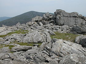
Crags on the summit of Mynydd Graig Goch
Elevation 610 m (2,001 ft)
Parent peak Craig Cwm Silyn
Listing Hewitt, Nuttall
Translation Mountain of the Red Rock (Welsh)
Location
Location Snowdonia, Wales
Coordinates 53°00′47″N 4°14′29″W / 53.0130°N 4.2415°W / 53.0130; -4.2415Coordinates: 53°00′47″N 4°14′29″W / 53.0130°N 4.2415°W / 53.0130; -4.2415
Topo map OS Landranger 115
OS grid SH4948

Mynydd Graig Goch (Welsh for Mountain of the Red Rock) is the western end peak of the Nantlle Ridge, and is a subsidiary summit of Craig Cwm Silyn. It is also the most westerly 2000 ft peak in Wales. For many years it was excluded from peak list due to the OS giving it an elevation of 609m. However, this all changed in 2008. After years of speculation a group of hill walkers carried out a detailed GPS survey of the peak, measuring the absolute height as 609.75 m (2000.49 ft).[1]

Panorama and Topography

The summit is boulder strewn, crowned by several tors of rock, of which one is the true summit. The southern and western flanks comprise of large boulder fields. The north-east face has steep cliffs, that form the backwall of the glacial Cwm Dulyn. Cwm Dulyn's lake Llyn Cwm Dulyn contains a population of Arctic Char. Views from the summit are extensive, overseeing Lleyn and the coast. Garnedd Goch, Mynydd Mawr, Moel Hebog and Yr Wyddfa (Snowdon) are all observable.

References

  1. ^ Wainwright, Martin (19 September 2008). "The Welshmen Who Went Up a Hill, but Came Down a Mountain". Guardian.co.uk. http://www.guardian.co.uk/uk/2008/sep/19/wales. Retrieved 23 August 2009. 

External links


Wikimedia Foundation. 2010.

Игры ⚽ Нужна курсовая?

Look at other dictionaries:

  • Craig Cwm Silyn — Craig Cwm Silyn, seen from the cwm silyn. Elevation 734 m (2,408 ft) …   Wikipedia

  • Moel Hebog — Moel Hebog, seen from the south Elevation 782 m (2,566 ft) …   Wikipedia

  • Nantlle Ridge — Y Garn, the usual starting point for the Nantlle Ridge walk, seen from Rhyd Ddu The Nantlle Ridge is the name given to a small range of mountains in Snowdonia, north Wales which runs south west from the village of Rhyd Ddu for a distance of about …   Wikipedia

  • Hill lists in the British Isles — The mountains and hills of Great Britain, and to a lesser extent Ireland, are the subject of a considerable number of lists that categorise them by height, topographic prominence, or other criteria. They are commonly used as a basis for peak… …   Wikipedia

  • List of Hewitts and Nuttalls in Wales — The Snowdon Massif =The Arenigs= The RhinogyddRadnor ForestThe Brecon Beaconsee also* Hill lists in the British Isles * List of Hewitts and Nuttalls in England * Marilyn * List of mountains of the British Isles by relative height a full list of… …   Wikipedia

  • Y Rhiw — Localidad de Gales …   Wikipedia Español

  • Aberdaron — Coordinates: 52°48′29″N 4°42′36″W / 52.808°N 4.710°W / 52.808; 4.710 …   Wikipedia

  • Aberdaron — Localidad de Gales …   Wikipedia Español

  • Criccieth — Coordinates: 52°55′01″N 4°14′11″W / 52.91697°N 4.23626°W / 52.91697; 4.23626 …   Wikipedia

  • List of communities in Wales — This is a list of communities in Wales sorted by principal area. The community is the lowest tier of local government in Wales and is usually represented by a community council. Contents 1 Blaenau Gwent 2 Bridgend 3 Caerphilly …   Wikipedia

Share the article and excerpts

Direct link
Do a right-click on the link above
and select “Copy Link”