- Mulegé Municipality
-
Comondú — Municipality — 
Coat of armsLocation of Mulegé in Baja California Sur.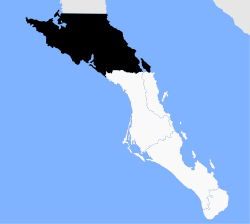
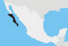
Country Mexico State Baja California Sur Municipal seat Santa Rosalía Largest city Guerrero Negro Population (2010) – Total 59,114 Time zone PST (UTC-8) – Summer (DST) PDT (UTC-7) Mulegé is the northernmost municipality of the Mexican state of Baja California Sur. It is the second-largest (behind only Ensenada) municipality by area in the country, with an area of 32,092.2 km² (12,777 sq mi). In the census of 2010 it had a population of 59,114 inhabitants. Isla Natividad is part of the municipality.
The municipal seat is located in Santa Rosalía.
There is an initiative to split the municipality into two, with the division along the ridge dividing the current municipality, so that the Pacific side, which includes its largest city, Guerrero Negro, and also Villa Alberto Andrés Alvarado Arámburo, would be separated from the Gulf of California side, which includes Santa Rosalía and Mulegé.
Subdivisions
Including the municipal seat of Santa Rosalía, the municipality is subdivided into six delegaciones:
- Santa Rosalía
- Bahía Tortugas
- Guerrero Negro
- Mulegé
- San Ignacio
- Vizcaíno
Communities
The census of 2010 lists 459 populated places, of which 90 had a population of 10 or more, and 38 of 100 or more. Those of 500 or more are listed below:
Name 2010 Census Population Guerrero Negro 13,054 Santa Rosalía 11,765 Villa Alberto Andrés Alvarado Arámburo 6,902 Heroica Mulegé 3,821 Bahía Tortugas 2,671 San Francisco 2,152 Las Margaritas 1,595 Bahía Asunción 1,484 El Silencio 1,190 Gustavo Díaz Ordaz 969 Estero de la Bocana 967 Punta Abreojos 788 San Ignacio 667 Los Mártires 651 San Bruno 623 Ejido San Lucas 606 Total Municipality 59,114 References
- 2010 census tables: INEGI: Instituto Nacional de Estadística, Geografia e Informática (INEGI)
- Los 20 Municipios Más Extensos Instituto Nacional Para el Federalismo y el Desarrollo Municipal
Municipalities and
municipal seatsComondú (Ciudad Constitución) · Mulegé (Santa Rosalía) · La Paz (La Paz) · Los Cabos (San José del Cabo) · Loreto (Loreto)
 Categories:
- Municipalities of Baja California Sur
- Mexico geography stubs


Wikimedia Foundation. 2010.