Münchwilen District

Münchwilen District
Münchwilen District
Bezirk Münchwilen
—  District  —
Country  Switzerland
Canton  Thurgau
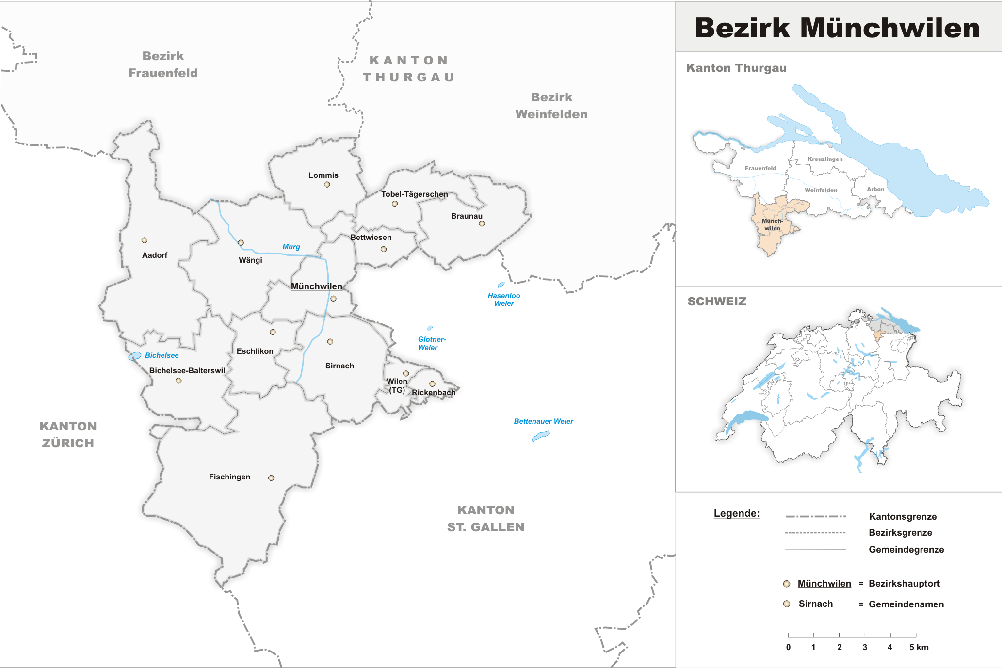
Capital Münchwilen
Area
 – Total 155.86 km2 (60.2 sq mi)
Population (2009)
 – Total 41,496
 – Density 266.2/km2 (689.6/sq mi)
Time zone CET (UTC+1)
 – Summer (DST) CEST (UTC+2)
Municipalities 13

Münchwilen District is one of the five districts of the canton of Thurgau, Switzerland. It has a population of 41,496 (as of 31 December 2009).[1] Its capital is the town of Münchwilen.

The district contains the following municipalities:

Coat of arms Municipality Population
(31 December 2009)[1]
Area
km²
[2]
Wappen Aadorf.svg Aadorf 7,980 20.0
Bettwiesen-Blazono.png Bettwiesen 1,054 3.85
Bichelsee-Balterswil-Blazono.png Bichelsee-Balterswil 2,575 12.27
Braunau(Turgovio)-Blazono.png Braunau 677 9.19
Eschlikon(Turgovio)-Blazono.png Eschlikon 3,808 6.20
Fischingen(Turgovio)-Blazono.png Fischingen 2,562 30.67
Lommis.gif Lommis 1,086 8.63
Muenchwilen-Blazono.png Münchwilen (TG) 4,760 7.78
Rickenbach(Turgovio)-Blazono.png Rickenbach (TG) 2,510 1.57
Sirnach-Blazono.png Sirnach 6,929 12.43
Tobel-Taegerschen-Blazono.png Tobel-Tägerschen 1,380 7.07
Wappen Waengi.svg Wängi 4,067 16.41
Wilenr.jpg Wilen (TG) 2,056 2.26
Total (13) 41,496 138.22

References

  1. ^ a b Statistical Office of Thurgau, MS Excel document – Wohnbevölkerung der Gemeinden am 31. Dezember 2009 nach Nationalität und Geschlecht (German) accessed 22 June 2010
  2. ^ Swiss Federal Statistical Office-Land Use Statistics 2009 data (German) accessed 25 March 2010

Coordinates: 47°29′00″N 8°59′00″E / 47.4833°N 8.98333°E / 47.4833; 8.98333


Wikimedia Foundation. 2010.

Игры ⚽ Поможем написать курсовую

Look at other dictionaries:

  • Münchwilen (district) — Münchwilen is one of the eight districts of the canton of Thurgau, Switzerland. Its capital is the town of Münchwilen.The district contains the following municipalities …   Wikipedia

  • District De Münchwilen — Pays  Suisse Canton Thurgovie Chef lieu …   Wikipédia en Français

  • District de Munchwilen — District de Münchwilen District de Münchwilen Pays  Suisse Canton Thurgovie Chef lieu …   Wikipédia en Français

  • District de münchwilen — Pays  Suisse Canton Thurgovie Chef lieu …   Wikipédia en Français

  • Münchwilen, Thurgau — For the municipality in Aargau, Switzerland, see Münchwilen, Aargau. Münchwilen Münchwilen village Country Switze …   Wikipedia

  • District suisse — Districts suisses Carte de la Suisse indiquant sa subdivision en cantons et en districts. En Suisse, le district est une subdivision territoriale qui existe dans la majorité des cantons. Sommaire …   Wikipédia en Français

  • District de Münchwilen — Pays Suisse Canton Thurgovie Chef lieu Münchwilen Superficie 138,22 km² [ …   Wikipédia en Français

  • Munchwilen (Thurgovie) — Münchwilen (Thurgovie) Pour les articles homonymes, voir Münchwilen. Münchwilen Une vue d ensemble de la commune serait la bienvenue Administration Pays …   Wikipédia en Français

  • Munchwilen (Argovie) — Münchwilen (Argovie) Pour les articles homonymes, voir Münchwilen. Münchwilen Une vue d ensemble de la commune serait la bienvenue Administration Pays …   Wikipédia en Français

  • District De Laufenburg — Le district de Laufenburg est un district du canton d Argovie qui compose, avec celui de Rheinfelden, la région du Fricktal. Le district compte 23 communes pour une superficie de 152.56 km² et une population de 27 012 habitants (fin 2004).… …   Wikipédia en Français

Share the article and excerpts

Direct link
Do a right-click on the link above
and select “Copy Link”