- Mount Wycheproof
-
Mount Wycheproof 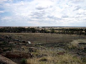
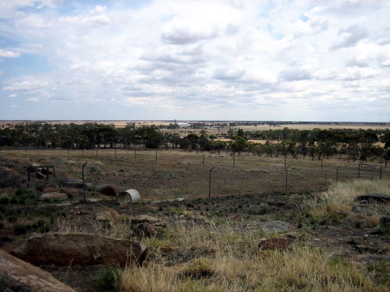
View from the Mount Wycheproof LookoutElevation 148 m (486 ft) [1] Location Location Wycheproof, Victoria, Australia Range Terrick Terrick Range Coordinates 36°04′37″S 143°14′02″E / 36.077°S 143.234°ECoordinates: 36°04′37″S 143°14′02″E / 36.077°S 143.234°E Mount Wycheproof is a mountain located in the small town of Wycheproof, Australia. Standing at 43 metres (141 ft) above the surrounding terrain, Mount Wycheproof has the distinction of being the smallest registered mountain in the world.[2] The township of Wycheproof is located on the mountain, and a unique geological substance known as Wycheproofite is exclusive to the local area.
History
The township of Wycheproof is a small township located on the mountain's south western slopes[3] The settlement was started as early as 1846, but the township was not surveyed until 1875. The name 'Wycheproof' originates from the local Aboriginal language, 'wichi-poorp', meaning 'grass on a hill'.[4] The mountain plays a role in the local community, with annual races to the summit of the mountain being played.[4] There are many walking tracks in the area, and local wildlife such as emus and kangaroos can be seen.[4]
Geology
Mount Wycheproof is a granite outcrop, formed thousands of years ago. Located in a flat grassland area, the rounded terrain of Mount Wycheproof is consistent with that of the surrounding area.[3][5] Sharing several similarities to nearby Pyramid Hill, Mount Wycheproof is part of the low lying Terrick Terrick range.[3] The mountain rises to a height of 148 metres (486 ft)[1] above sea level or only 43 metres (141 ft) above the surrounding plains, making it the smallest registered mountain in the world.[2][6] The mountain is characterised by a rocky, conical peak, common in the western areas of Victoria.[3] Phosphate materials are relatively rare in Victoria,[7] yet the Wycheproof area is known to have its own unique mineral, known as Wycheproofite.[8] Wycheproofite can be characterised by its pinkish colour and its transparency.[8]
References
- ^ a b The Royal Australian Survey Corps (1987). St Arnaud (Map). 1:250,000, Series 1501 (1st ed.). Section YF0105.
- ^ a b "Interesting Facts - Geography". James Yolkowski. 13 January 2008. http://www.sentex.net/~ajy/facts/geography.html. Retrieved 20 November 2008.
- ^ a b c d "4.4 Hills and Low Hills". State of Victoria. 24 September 2008. http://www.dpi.vic.gov.au/dpi/vro/vrosite.nsf/pages/landform_geomorphological_framework_4.4. Retrieved 20 November 2008.
- ^ a b c "Wycheproof - Victoria - Australia". Sydney Morning Herald. 8 February 2004. http://www.smh.com.au/news/victoria/wycheproof/2005/02/17/1108500207659.html. Retrieved 20 November 2008.
- ^ "Our Environment". Friends of Mount Wycheproof. Archived from the original on 18 July 2008. http://web.archive.org/web/20080718224425/http://www.wycheproof.vic.au/our_environment/our_environment.html. Retrieved 20 November 2008.
- ^ "7:30 Report - 01/11/2004". Australian Broadcasting Corporation. 1 November 2004. http://www.abc.net.au/7.30/content/2004/s1232503.htm. Retrieved 20 November 2008.
- ^ "Mineralogy and Petrology". Museum Victoria. 20 August 1996. http://museumvictoria.com.au/mineralogy/granit.html. Retrieved 20 November 2008.
- ^ a b "mineral general info". Queensland University of Technology. http://www.mineralatlas.com/mineral%20general%20descriptions/W/wycheproofitepcd.htm. Retrieved 20 November 2008.
Categories:- Mountains of Victoria (Australia)
Wikimedia Foundation. 2010.