Mount Oberlin

Mount Oberlin
Mount Oberlin

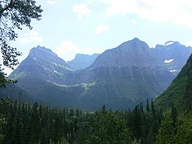
Mount Oberlin at left towers over Bird Woman Falls
Elevation 8,180 ft (2,493 m) [1]
Prominence 660 ft (201 m) [1]
Location
Location Flathead County, Montana, USA
Range Lewis Range
Coordinates 48°42′16″N 113°44′09″W / 48.70444°N 113.73583°W / 48.70444; -113.73583Coordinates: 48°42′16″N 113°44′09″W / 48.70444°N 113.73583°W / 48.70444; -113.73583[2]
Topo map USGS Logan Pass, MT

Mount Oberlin (8,180 feet (2,493 m)) is located in the Lewis Range, Glacier National Park in the U.S. state of Montana.[3] Mount Oberlin is just northwest of Logan Pass. Below the summit to the northwest, water and melting snow off Mount Oberlin lead to the 492 feet (150 m) Bird Woman Falls, one of the tallest waterfalls in Glacier National Park.

See also

Cited references


Wikimedia Foundation. 2010.

Игры ⚽ Поможем написать реферат

Look at other dictionaries:

  • Mount Holyoke College — Seal of Mount Holyoke College Motto That our daughters may be as corner stones, polished after the similitude of a palace  Psalms 144:12 Established Seminary, 183 …   Wikipedia

  • Mount Alberta — seen from near the summit of Diadem Peak Elevation 3,619 m (11,873 ft …   Wikipedia

  • Oberlin College — Coordinates: 41°17′35″N 82°13′07″W / 41.292929°N 82.218576°W / 41.292929; 82.218576 …   Wikipedia

  • Oberlin Group — The Oberlin Group is an informal consortium of the libraries of approximately 80 selective liberal arts colleges in the United States. The group developed as a result of conferences held in 1984 85 at Oberlin College when the presidents of 50… …   Wikipedia

  • Mount Holyoke College — 42° 15′ 20″ N 72° 34′ 28″ W / 42.25558, 72.5745 …   Wikipédia en Français

  • Mountains and mountain ranges of Glacier National Park (U.S.) — Map of all coordinates from Google Map of all coordinates from Bing Export all coordinat …   Wikipedia

  • Glacier National Park (U.S.) — Infobox protected area | name = Glacier National Park iucn category = II caption = locator x = 67 locator y = 17 location = Flathead County Glacier County, flagicon|Montana Montana, USA nearest city = Kalispell lat degrees = 48 lat minutes = 48… …   Wikipedia

  • Bird Woman Falls — is a 492 foot (150 m) waterfall located immediately west of the continental divide in Glacier National Park, Montana, United States. The falls are readily visible from a distance of two miles (3.2 km) along the Going to the Sun Road, which… …   Wikipedia

  • Ohio high school athletic conferences — This is a list of high school athletic conferences in Ohio.[1] Because the names of localities and their corresponding high schools do not always match and because there is often a possibility of ambiguity with respect to either the name of a… …   Wikipedia

  • Diane E. Meier — Diane E. Meier, M.D. Born April 15, 1952(1952 04 15) Princeton, New Jersey Citizenship American …   Wikipedia

Share the article and excerpts

Direct link
Do a right-click on the link above
and select “Copy Link”