- Morton Pinkney railway station
-
Morton Pinkney Location Place Moreton Pinkney Area South Northamptonshire Grid reference SP575498 Operations Original company East and West Junction Railway Pre-grouping Stratford-upon-Avon and Midland Junction Railway Post-grouping London, Midland and Scottish Railway
London Midland Region of British RailwaysPlatforms 2 History 1 July 1873[1] Opened 1 August 1877 Closed 22 February 1885 Reopened 7 April 1952[2] Closed Disused railway stations in the United Kingdom Closed railway stations in Britain
A B C D–F G H–J K–L M–O P–R S T–V W–ZMorton Pinkney (also known as Morton Pinkney for Sulgrave) was a railway station on the Stratford-upon-Avon and Midland Junction Railway (SMJ) which served the Northamptonshire village of Moreton Pinkney between 1873 and 1952. It was situated not far from Sulgrave Manor, the ancestral home of George Washington's family.
Contents
History
A line from Greens Norton junction near Towcester to Stratford-upon-Avon and the junction with the Great Western Railway's Honeybourne branch line was first authorised in June 1864, but due to a lack of funds it took a further nine years for the line, built by the East and West Junction Railway (E&WJ), to be fully open to traffic.[3] A station was opened at Moreton Pinkney, a Northamptonshire village 11.5 miles (18.5 km) from Blisworth. As with other E&WJ stations, Morton Pinkney had a passing loop with two platforms and a single goods siding without a goods shed. Goods handled included milk collection and coal deliveries[4]; in addition, as many as 40 loads of cattle were dispatched on weekly Tuesday marketdays, the railway company laying on special trains to run to Blisworth and Broom. To the west of the small brick station building lay a 12-lever signal box which was switched out at night to create a long section from Woodford West junction and Blakesley when services were signalled in both directions on the Up line.[5]
A special gating crossing existed near the station for the use of local huntsmen, a key being provided to the local Master of Foxhounds. In 1912, the Stratford-upon-Avon and Midland Junction Railway, which had amalgamated with the E&WJ in 1908, agreed to cover all drains along the line and to replace barbed wire with ordinary wire in order to minimise the risk of injury to horse and hound.[6] In an attempt to boost passenger traffic, the station began to appear as Morton Pinkney for Sulgrave in timetables from January 1913, the railway company hoping that the mention of Sulgrave, the location of the home of George Washington's ancestors, would encourage tourists to use the line.[7] Passenger traffic continued to tail off and the station was finally closed in 1952, though the line through the station remained open for freight trains between Woodford West junction and Blisworth until 7 February 1964.[8]
Routes
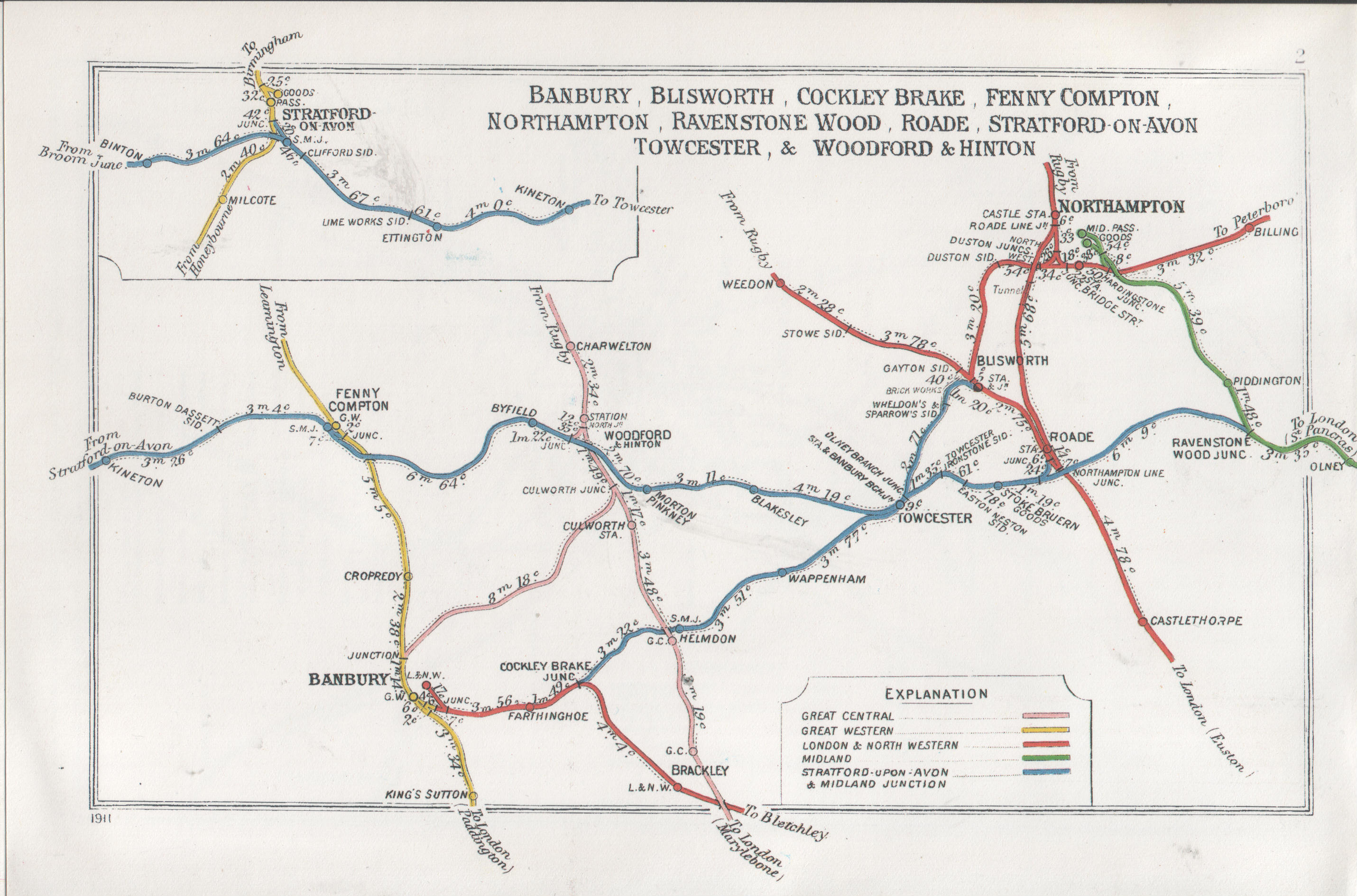
 A 1911 Railway Clearing House map of railways in the vicinity of Moreton Pinkney
Preceding station Disused railways Following station Byfield SMJR
East and West Junction RailwayBlakesley Present day
The station site has been redeveloped into light industrial use and the station buildings have been removed. The gate leading to the site does however carry a sign bearing the station's name.[9]
References
- ^ Butt, R.V.J. (1995). The Directory of Railway Stations, Patrick Stephens Ltd, Sparkford, ISBN 1-85260-508-1, p. 164.
- ^ Clinker, C.R. (October 1978). Clinker's Register of Closed Passenger Stations and Goods Depots in England, Scotland and Wales 1830-1977. Bristol: Avon-AngliA Publications & Services. p. 98. ISBN 0-90546-619-5.
- ^ Dunn, J.M. (1977). The Stratford & Midland Junction Railway. Blandford, Dorset: The Oakwood Press. p. 6. ISBN 0853610363.
- ^ Riley, R.C.; Simpson, B. (1999). A History of the Stratford-upon-Avon & Midland Junction Railway. Witney, Oxon: Lamplight Publications. p. 78. ISBN 9781899246205.
- ^ Jordan, Arthur (1982). The Stratford-upon-Avon and Midland Junction Railway: the Shakespeare route. Headington, Oxford: Oxford Railway Pub. Co.. p. 39. ISBN 8609-3131.
- ^ Jordan, A., p. 39.
- ^ Riley, R.C. and Simpson, B., p. 76.
- ^ Mitchell, Vic; Smith, Keith (November 2008). Branch Lines Around Towcester. Midhurst, West Sussex: Middleton Press. p. Plate 104. ISBN 9781906008390.
- ^ Kingscott, Geoffrey (2008). Lost Railways of Northamptonshire (Lost Railways Series). Newbury, Berkshire: Countryside Books. p. 121. ISBN 978-1-84674-108-1.
Coordinates: 52°08′38″N 1°09′39″W / 52.144009°N 1.160867°W
Closed railway stations in Northamptonshire Northampton to Market Harborough line Banbury to Blisworth Stratford-upon-Avon and Midland Junction Railway Byfield · Morton Pinkney · Blakesley · Stoke Bruern · Salcey ForestNorthampton and Peterborough Railway Northampton Bridge Street · Billing · Castle Ashby & Earls Barton · Wellingborough London Road · Ditchford · Irthlingborough · Ringstead & Addington · Thrapston Bridge Street · Thorpe · Barnwell · OundleRugby to Peterborough East Market Harborough to Bedford Higham Ferrers branch Great Central Main Line Northampton Loop Line Rugby to Bletchley Welton · Weedon · Blisworth · RoadeKettering to Huntingdon Cranford · Twywell · Thrapston Midland Road · RaundsKettering to Melton Mowbray Rugby and Stamford Railway Lilbourne · Yelvertoft & Stanford ParkWeedon to Marton Junction Other stations Ashley & Weston · Aynho Park · Aynho for Deddington · Brackley Town · Northampton St. John's Street · PiddingtonCategories:- Disused railway stations in Northamptonshire
- Former Stratford-upon-Avon and Midland Junction Railway stations
- Railway stations opened in 1873
- Railway stations closed in 1952
Wikimedia Foundation. 2010.