- Porterville, Utah
-
Porterville — Unincorporated community — Porterville Church in 2009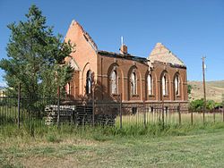 Location within the state of Utah
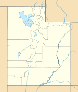
 Porterville
Coordinates: 40°58′53″N 111°40′42″W / 40.98139°N 111.67833°WCoordinates: 40°58′53″N 111°40′42″W / 40.98139°N 111.67833°W Country United States State Utah County Morgan Settled 1859 Founder Sanford and Warriner Porter Elevation[1] 5,151 ft (1,570 m) Time zone Mountain (MST) (UTC-7) – Summer (DST) MDT (UTC-6) ZIP code 84050 Area code(s) 435 FIPS code GNIS feature ID 1444594[1] Porterville is an unincorporated community in Morgan County, Utah, United States.
Contents
Geography
Porterville is located at the south end of Morgan County, four miles southwest of Morgan. It is situated at a junction between Hardscrabble Canyon and East Canyon.[2]
History
Porterville was first settled by Centerville residents Sanford and Nancy Warriner Porter in 1859. The area had abundant timber, so they built a sawmill, the first in Morgan County.[3] A town resident began teaching school out of her home in 1862, until a schoolhouse was built in 1867.[4]
Western Shoshone, led by Chief Washakie, continued to frequent the area to hunt and gather berries for several years after settlement began.[3]
Porterville Church
The original church house was erected in 1898 and subsequently dedicated in 1908 by President Joseph F. Smith. Eventually, costs of maintenance and needed repairs led the congregation to remodel the old school house and convert it for use as a church. Although the school house was sold to the ward in 1936, it was not until 1946 that regular meetings were held in the refinished space, mostly due to World War II. The church was sold to Marvin and Grace Kilbourn who, despite efforts at preservation, were unable to prevent vandalism over the next several decades. In 1970, the Bergman family purchased the church and remodeled it into a home while keeping the exterior intact.[5] In 1971, it was added to the Utah State Register of Historic Sites, which is now inactive.[6] In the conversion to a private home, the steeple tower that was wood framed with Gothic-arched frames on each side was removed.[7] After being seen in Troll 2 filmed in the area in 1989, a fire in 2000 destroyed all but a shell of the original building.[8]
The Utah State Historical Society Classified Photo Collection contains a photograph of the "Porterville Meeting House" taken in 1920.[9] Also, there is a LeConte Stewart painting of the church from 1948 titled "Country Funeral, Porterville" that was featured in a LDS Church History Museum exhibit called Landscape & Life: The Rural Setting of Latter-day Saints from 24 October 2003 to 18 April 2004.[10][11]
Mormon Flat Breastworks
Mormon Flat BreastworksNearest city: Porterville Built: 1857 Architectural style: Stone breastworks Governing body: Private MPS: Utah War Fortifications MPS NRHP Reference#: 88001943[12] Added to NRHP: October 27, 1988 The Mormon Flat Breastworks, fortification structures listed on the National Register of Historic Places, are located in Porterville. They consist of horizontal rock breastworks built by Mormons in 1857 to defend against "Johnston's Army" in the Utah War. The walls were originally built about 4 feet (1.2 m) high, with trenches dug for riflemen. A dam was also built on the nearby creek to force enemy soldiers to travel underneath them.[13] These fortifications were not used in battle, and their exact location is restricted.[12]
References
- ^ a b U.S. Geological Survey Geographic Names Information System: Porterville, Utah. Retrieved May 19, 2011.
- ^ Van Cott, John W. (1990). Utah Place Names. Salt Lake City, Utah: University of Utah Press. pp. 293. ISBN 0-87480-345-4.
- ^ a b Utah State History Markers and Monuments Database
- ^ Morgan County Historical Society
- ^ Kilbourn, Grace Bowen (1980). History of the old Porterville church, 1864-1948 : a delightful history and pictures of Porterville, Morgan County, Utah. Porterville, Utah: G.B. Kilbourn.
- ^ Utah State Register of Historic Sites (compiled 1988)
- ^ Roberts, Allen D. (1974). A Survey of L.D.S. Architecture in Utah, 1847-1930. Salt Lake City, Utah: A.D. Roberts.
- ^ Salt Lake Tribune, "State of the State: Morgan County," April 28, 2000
- ^ Utah State History Digital Collections, Porterville Meeting House
- ^ Church History Museum, Previous Exhibits
- ^ Landscape & Life: The Rural Setting of Latter-day Saints
- ^ a b "National Register Information System". National Register of Historic Places. National Park Service. 2009-03-13. http://nrhp.focus.nps.gov/natreg/docs/All_Data.html.
- ^ history.utah.gov
Municipalities and communities of Morgan County, Utah City 
CDP Unincorporated
communitiesCroydon | Peterson | Porterville
Categories:- Populated places in Morgan County, Utah
- Unincorporated communities in Utah
- Populated places established in 1859


Wikimedia Foundation. 2010.