- Mont-Apica, Quebec
-
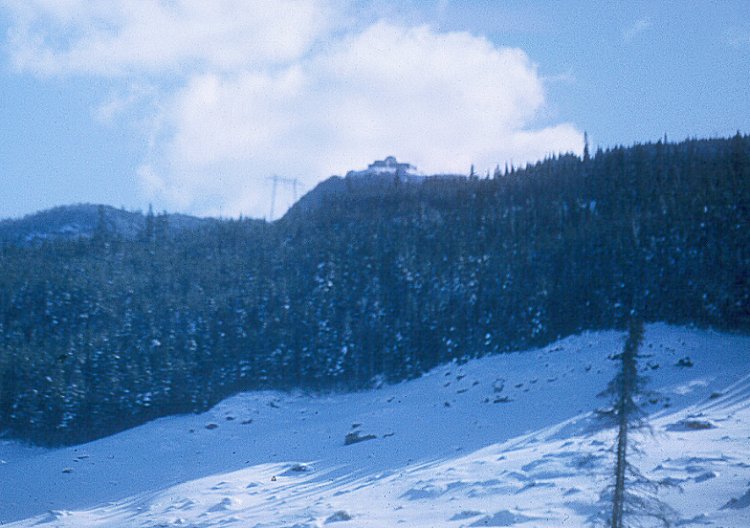
Mont-Apica — Unorganized territory — Radar station on Mont Apica
 Mont-Apica
Coordinates: 47°59′N 71°26′W / 47.983°N 71.433°WCoordinates: 47°59′N 71°26′W / 47.983°N 71.433°W Country  Canada
Province  Quebec
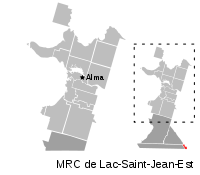
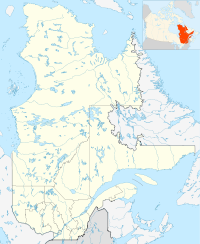
Region Saguenay–Lac-Saint-Jean Regional county Lac-Saint-Jean-Est Formed January 1, 1986 Government[1] - Federal riding Roberval—Lac-Saint-Jean - Prov. riding Lac-Saint-Jean Area[1][2] - Total 12.89 km2 (5 sq mi) - Land 12.68 km2 (4.9 sq mi) Population (2006)[2] - Total 0 - Density 0.0/km2 (0/sq mi) Time zone EST (UTC-5) - Summer (DST) EDT (UTC-4) Mont-Apica is an unorganized territory in the Canadian province of Quebec, located in the regional county municipality of Lac-Saint-Jean-Est. It had a population of zero in the Canada 2006 Census, and covered a land area of 12.68 km2 [2], entirely within the Laurentides Wildlife Reserve.
The territory was home to the former RCAF Station Mont Apica, located along Quebec Route 169 at the base of the eponymous Mount Apica. Part of the Pinetree Line and NORAD, the station became operational in 1952 and had a staff of some 500 persons at its peak. Political and technological changes made the station redundant and it closed in 1990.[3]
The Apica River, a small tributary of the Pikauba River, flows through the territory in a narrow and deep valley at the foot of the 884 metres (2,900 ft) high Mount Apica. The river and mountain were spelled as Upika or Upica until 1961, an Innu word meaning "narrowing river".[4]
Demographics
Population:[5]
- Population in 2006: 0
- Population in 2001: 0
- Population in 1996: 0
- Population in 1991: 5
References
- ^ a b Ministère des Affaires Municipales, Régions et Occupation du territoire - Répertoire des municipalités: Mont-Apica
- ^ a b c "Mont-Apica community profile". 2006 Census data. Statistics Canada. http://www12.statcan.gc.ca/census-recensement/2006/dp-pd/prof/92-591/details/page.cfm?Lang=E&Geo1=CSD&Code1=2493902&Geo2=PR&Code2=24&Data=Count&SearchText=Mont-Apica&SearchType=Begins&SearchPR=01&B1=All&Custom=. Retrieved 2010-10-28.
- ^ "Mont-Apica (Lieu-dit)" (in French). Commission de toponymie du Québec. http://www.toponymie.gouv.qc.ca/ct/ToposWeb/fiche.aspx?no_seq=42026. Retrieved 2010-10-28.
- ^ "Rivière Apica" (in French). Commission de toponymie du Québec. http://www.toponymie.gouv.qc.ca/ct/ToposWeb/fiche.aspx?no_seq=1750. Retrieved 2010-10-28.
- ^ Statistics Canada: 1996, 2001, 2006 census

Lac-Achouakan Lac-Ministuk Lac-Moncouche 
Lac-Pikauba  Mont-Apica

Lac-Jacques-Cartier Administrative divisions of Saguenay-Lac-Saint-Jean (Region )Regional county municipalities
and equivalent territoriesMunicipalities Albanel · Alma · L'Anse-Saint-Jean · L'Ascension-de-Notre-Seigneur · Bégin · Chambord · Desbiens · Dolbeau-Mistassini · Ferland-et-Boilleau · Girardville · Hébertville · Hébertville-Station · La Doré · Labrecque · Lac-Bouchette · Lamarche · Larouche · Métabetchouan-Lac-à-la-Croix · Normandin · Notre-Dame-de-Lorette · Péribonka · Petit-Saguenay · Rivière-Éternité · Roberval · Saguenay · Saint-Ambroise · Saint-André-du-Lac-Saint-Jean · Saint-Augustin · Saint-Bruno · Saint-Charles-de-Bourget · Saint-David-de-Falardeau · Saint-Edmond-les-Plaines · Saint-Eugène-d'Argentenay · Saint-Félicien · Saint-François-de-Sales · Saint-Fulgence · Saint-Félix-d'Otis · Saint-Gédéon · Saint-Henri-de-Taillon · Saint-Honoré · Saint-Ludger-de-Milot · Saint-Nazaire · Saint-Prime · Saint-Stanislas · Saint-Thomas-Didyme · Sainte-Hedwidge · Sainte-Jeanne-d'Arc · Sainte-Monique · Sainte-Rose-du-Nord
Categories:- Unorganized areas in Saguenay-Lac-Saint-Jean
- Quebec geography stubs


Wikimedia Foundation. 2010.