Mokil Atoll

Mokil Atoll

Coordinates: 6°40′N 159°46′E / 6.667°N 159.767°E / 6.667; 159.767

Mokil

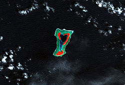
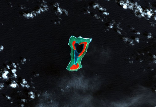
Landsat false colour satellite photograph of Mokil
Geography
Location Pacific Ocean
Coordinates 6°40′N 159°46′E / 6.667°N 159.767°E / 6.667; 159.767
Archipelago Caroline Islands
Total islands 3
Major islands Urak, Kahlap, Manton
Area 2 km2 km2 (Expression error: Unrecognised word "km" sq mi)
Country
Demographics
Population 147 (as of 2008 census)
Ethnic groups Mokil, Polynesian

Mokil (also Mwoakilloa, previously named Wellington Island or Duperrey Island) is an inhabited atoll in the central Pacific Ocean. Geographically, it belongs to the Caroline Islands and is a district of the outlying islands of Pohnpei of the Federated States of Micronesia.

Mokil lies 153 kilometres east of Pohnpei and approximately 113 kilometres northwest of Pingelap. The almost-rectangular atoll is 4.5 kilometres long and 2.8 kilometres broad. The atoll consists of the three islands Urak, Kahlap (Mokil), and Manton, forming a central lagoon of approximately 2 square kilometres in area. Only the northeast island Kahlap is inhabited, with the town facing the lagoon. The total area of all islands is approximately 1.24 square kilometres.

The population of Mokil decreased from 177 in 2000[1] to 147 in 2008. The inhabitants speak Mokilese — similar to the Pohnpeian language in the family of Micronesian languages.


References

External links


Wikimedia Foundation. 2010.

Игры ⚽ Поможем написать курсовую

Look at other dictionaries:

  • Mokil (Atoll) — Vorlage:Infobox Insel/Wartung/Höhe fehlt Mokil Landsat Falschfarbenbild von Mokil Gewässer Pazifischer Ozean Archipel …   Deutsch Wikipedia

  • Mokil — ist der Name eines russischen Regisseurs, siehe Sarra Mokil eines Atolls im Archipel der Karolinen, siehe Mokil (Atoll) eines Sohnes von Assur und Enkels von Sem, siehe Mokil (Bibel) Diese Seite ist eine Begriffsklärung …   Deutsch Wikipedia

  • Mokil — Atoll, Pohnpei State, Micronesia, Pacific Ocean Mokil is a village and municipality in the state of Pohnpei, Federated States of Micronesia. Reference Statoids.com, retrieved December 8, 2010 …   Wikipedia

  • Mokil — 6°40′N 159°46′E / 6.667, 159.767 Mokil (également connue comme Mwoakilloa, auparavant Wellington Island ou île Duperrey) est un …   Wikipédia en Français

  • Mokil (langue) — Mokil Parlée en  Micronésie Région Mokil Nombre de locuteurs 1 230 (1979) …   Wikipédia en Français

  • Oroluk (Atoll) — Vorlage:Infobox Insel/Wartung/Höhe fehlt Oroluk Atoll Karte des Oroluk Atolls Gewässer Pazifischer Ozean Archipel …   Deutsch Wikipedia

  • Ant (Atoll) — Vorlage:Infobox Insel/Wartung/Höhe fehlt Ant Karte der Senjawin Inseln mit Ant im Südwesten Gewässer Pazifischer Ozean …   Deutsch Wikipedia

  • Pohnpei — Not to be confused with Pompeii, the ancient city destroyed by Vesuvius in AD 79. Kolonia Town looking down from Sokehs Ridge …   Wikipedia

  • Mokilese language — Mokilese Spoken in Micronesia Region Mokil atoll Native speakers unknown (1,230 cited 1979) Language family Austronesian …   Wikipedia

  • Liste der Inseln der Föderierten Staaten von Mikronesien — Karte der Föderierten Staaten von Mikronesien Die Liste der Inseln der Föderierten Staaten von Mikronesien listet alle Inseln, Inselgruppen und Atolle diese Inselstaates auf, geordnet alphabetisch nach Bundesstaat. Alle Inseln und Atolle gehören… …   Deutsch Wikipedia

Share the article and excerpts

Direct link
Do a right-click on the link above
and select “Copy Link”