- Mnquma Local Municipality
-
Mnquma Local Municipality — Local municipality — Location in the Eastern Cape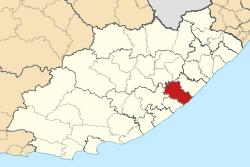
Country South Africa Province Eastern Cape District Amatole District Seat Butterworth Area - Total 3,299 km2 (1,273.8 sq mi) Population (2007)[1] - Total 297,663 - Density 90.2/km2 (233.7/sq mi) - Households 75,410 Racial makeup[2] (2007) - Black African 99.28% - White 0.10% - Coloured 0.52% - Indian or Asian 0.10% Time zone SAST (UTC+2) Municipal code EC122 Website http://www.mnquma.gov.za/ Mnquma Local Municipality is an administrative area in the Amatole District of the Eastern Cape in South Africa.
References
- ^ "Community Survey, 2007: Basic Results Municipalities" (PDF). Statistics South Africa. http://www.statssa.gov.za/Publications/P03011/P030112007.pdf. Retrieved 2009-10-20.
- ^ "Community Survey 2007 interactive data". Statistics South Africa. http://www.statssa.gov.za/community_new/content.asp?link=interactivedata.asp. Retrieved 19 October 2009.
Province of Eastern Cape, South Africa Provincial Capital: Bhisho Metropolitan
MunicipalitiesBuffalo City · Nelson Mandela BayDistrict
and Local
MunicipalitiesCamdeboo · Blue Crane Route · Ikwezi · Makana · Ndlambe · Sunday's River Valley · Baviaans · Kouga · Kou-KammaInxuba Yethemba · Tsolwana · Inkwanca · Lukhanji · Intsika · Emalahleni · Engcobo · SakhisizweElundini · Senqu · Maletswai · GariepCategories:- Local Municipalities of Amatole

Wikimedia Foundation. 2010.