- Mill Valley, Calaveras County, California
-
Mill Valley is a former settlement in Calaveras County, California, 9.5 miles (15.3 km) northeast of Mokelumne Hill.[1] A post office operated in Mill Valley from 1856 to 1861.[1]
References
Municipalities and communities of Calaveras County, California County seat: San Andreas City 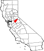
CDPs Arnold | Avery | Copperopolis | Dorrington | Forest Meadows | Mokelumne Hill | Mountain Ranch | Murphys | Rail Road Flat | Rancho Calaveras | San Andreas | Vallecito | Valley Springs | Wallace | West Point
Unincorporated
communitiesAlabama Hill | Big Bar | Big Meadow | Big Trees | Big Trees Village | Big Valley | Blue Lake Junction | Blue Lake Springs | Bummerville | Burson | Calaveritas | Camp Connell | Camp Pardee | Campo Seco | Canyon View | Carmen City | Cave City | Cedar Vista | Copper Cove Subdivision | Copper Cove Village | Cottage Springs | Douds Landing | Douglas Flat | Ebbetts Pass Highlands | Felix | Fisher Place | Fly-In Acres | Fort Jones | Fourth Crossing | Fuchs | Ganns | Glencoe | Goodmans Corner | Grizzly Ridge | Hams | Hanford Hill | Happy Valley | Hathaway Pines | Hathaways Mountain Pines | Independence | Indian Creek | Indian Hills | Jenny Lind | Jesus Maria | La Honda Park | Lake Camanche Ranches | Lakemont Pines | Lakeside Terrace | Lilac Park | Lombardi | Lost City | Lynn Park Acres | Manuel Mill | McKay | Meadowmont | Milton | Mother Lode Acres | Mountain Ranch Subdivision | Mountain Retreat | Mumbert Acres | Oak Grove | Oak Park Estates | Paloma | Pinebrook | Ponderosa Park | Porter | Quail Oaks | Red Apple | Rich Gulch | Rocky Hill | Sandoz | Sandy Gulch | Scenic Valley Ranchos | Sheep Ranch | Sherman Acres | Skyhigh | Snowshoe Springs | South Camanche Shore | Sunset Point | Tamarack | Tamarack Springs | Telegraph City | The Shores of Poker Flat | Timber Trails | Toyanza Subdivision | Toyon | White Pines | Wilseyville | Wyldewood
Former
settlementsAltaville | Antelope House | Balaklava Hill | Blue Mountain | Brownsville | Buckeye Hill | Camanche | Camp Spirito | Carson Hill | Chichi | El Dorado Bar | Fremont Valley | Greasertown | Hodson | Independence Flat | Lower Calaveritas | Mammoth Cave | McLeans Bar | McLeans Ferry | Melones | Mill Valley | North American House | Norval | Oregon Bar | Pattees Ranch | Poverty Bar | Sandy Bar | Spanish Bar | Stony Bar | Stoutenburg | Taylors Bar | Tremont House | Yaqui Camp
Categories:- Former settlements in Calaveras County, California
- Former populated places in California
- Calaveras County, California geography stubs

Wikimedia Foundation. 2010.