- Mile 17 fire
-
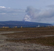 Smoke plume from May 13 flare-up seen from the Homer Spit, about 20 miles away
The Mile 17 fire was a wildfire that began at about mile 17 of East End Road outside of Homer, Alaska on Tuesday, May 12, 2009 and lasted until Sunday, May 17.
Contents
Background
Part of a series on
Wildland
Firefighting
Main articles Wildfire · Bushfires · Wildfire suppression
Tactics & Equipment Aerial firefighting · Controlled burn · Firebreak · Fire trail · Fire lookout tower · Fire-retardant gel · Fire fighting foam · Fire retardant · Helicopter bucket · Driptorch
Personnel Handcrew · Hotshots · Helitack · Smokejumper · Rappeller · Engine crew
Lists List of wildfires
Glossary of wildfire termsSouth-central Alaska had been experiencing unusually warm, dry weather for about ten days before the fire [1], and a downed power line apparently ignited dry brush on May 12. Parts of the fire were in forested areas that are inside Kachemak Bay State Park. The Kachemak Bay area was infested by spruce bark beetles in the 1990s, and many dead, dry trees remained in this area.
Firefighting efforts
On Wednesday, May 13 the fire was seemingly under partial control in the morning, but flared up violently due to afternoon winds and began to spread again. Fire crews asked for all available resources, and by the late afternoon over 100 firefighters and numerous pieces of heavy equipment were committed to the fire, along with water tanker trucks and fire-suppression aircraft.[2] The fire continued to spread rapidly and evacuation orders were issued for residents in the area, including the villages of Razdolna and Voznesenka. In less than 24 hours the fire had spread from 70 acres (280,000 m2) to an estimated 700 acres (2.8 km2), and efforts were shifted from actively fighting the fire to protecting lives and homes.[3]
As of the afternoon of May 14, the fire had grown to nearly 1,000 acres (4.0 km2) and was continuing to spread. Two strike teams were dispatched by the Anchorage Fire Department and Central Mat-Su Fire Department, and a team of smokejumpers arrived. A Type 1 Incident Command Team took over command of firefighting efforts.
On Friday, May 15, the weather changed and a light rain fell in the fire area, allowing crews an opportunity to contain the fire. Firefighters reported that many areas within the fire perimeter were not burned, and only 2 structures were confirmed lost. The fire was estimated to be 25% contained.[4]
By the weekend, about 245 personnel were on hand to combat the fire. Continued humid weather facilitated major progress over 16 and 17 May, and the fire was 65% contained. Three homes and two other buildings were confirmed destroyed, out of approximately fifty homes in the fire area.[5]
Aftermath
At 6:00pm on Sunday May 17, the fire was declared to be 100% contained. Fire fighting efforts shifted to finding remaining hot spots inside the perimeter and extinguishing them. Total affected area was 1,074 acres (4.35 km2), with eight structures destroyed.[6]
See also
- 2007 Caribou Hills fire
- Shanta Creek fire
References
- ^ Firefighters Battle First Wildfire Of The Season East Of Homer (mp3 audio file) Casey Kelly/KBBI AM890 May 13, 2009
- ^ 40 Homes threatened by blaze near mile 17 East End Road Homer News, Wed. May 13 2009
- ^ Homer fire threatens Old Believer villages Anchorage Daily News May 13th, 2009 11:51 PM
- ^ East End Road open to residents, Community meeting on fire is Saturday Homer News May 15, 2009
- ^ Crews are making some progress against Homer wildfire Anchorage Daily News May 17th, 2009 12:44 AM
- ^ Mile 17 fire 100 percent contained, Mop-up continues of hot spots Homer News 5:50 PM on Monday, May 18, 2009
Categories:- 2009 wildfires
- Kenai Peninsula Borough, Alaska
- Wildfires in Alaska
- 2009 in Alaska

Wikimedia Foundation. 2010.