- Mesovortices
-
Mesovortices are small scale rotational features found in convective storms, such as those found in bow echos, supercell thunderstorms and the eyewall of tropical cyclones.[1][2]
Contents
Eyewall mesovortices
Eyewall mesovortices are small scale rotational features found in the eyewalls of intense tropical cyclones. They are similar, in principle, to small "suction vortices" often observed in multiple-vortex tornadoes. In these vortices, wind speed can be up to 10% higher than in the rest of the eyewall. Eyewall mesovortices are most common during periods of intensification in tropical cyclones.
Eyewall mesovortices often exhibit unusual behavior in tropical cyclones. They usually rotate around the low pressure center, but sometimes they remain stationary. Eyewall mesovortices have even been documented to cross the eye of a storm. These phenomena have been documented observationally,[2] experimentally,[3] and theoretically.[4]
Eyewall mesovortices are a significant factor in the formation of tornadoes after tropical cyclone landfall. Mesovortices can spawn rotation in individual thunderstorms (a mesocyclone), which leads to tornadic activity. At landfall, friction is generated between the circulation of the tropical cyclone and land. This can allow the mesovortices to descend to the surface, causing large outbreaks of tornadoes.
Mesocyclone
 Main article: Mesocyclone
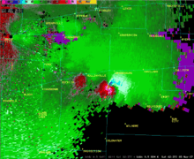
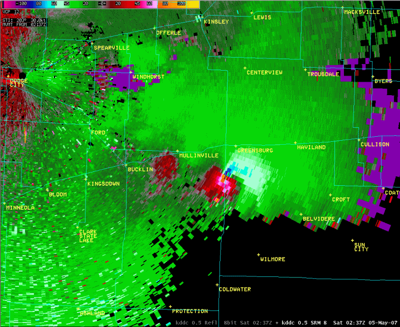
A mesocyclone is a type of mesovortex, approximately 2 to 10 km in diameter (the mesoscale of meteorology), within a convective storm.[5] Mesocyclones are air that rises and rotates around a vertical axis, usually in the same direction as low pressure systems in a given hemisphere. They are most often associated with a localized low-pressure region within a severe thunderstorm. Mesocyclones are believed to form when strong changes of wind speed and/or direction with height ("wind shear") sets parts of the lower part of the atmosphere spinning in invisible tube-like rolls. The convective updraft of a thunderstorm is then thought to draw up this spinning air, tilting the air's axis of rotation upward (from parallel to the ground to perpendicular) and causing the entire updraft to rotate as a vertical column. Mesocyclones are normally relatively localized: they lie between the synoptic scale (hundreds of kilometers) and small scale (hundreds of meters). Radar imagery is used to identify these features.
References
- ^ Atkins, N. T.; Laurent, M. St. (2009-05). "Bow Echo Mesovortices. Part II: Their Genesis". Monthly Weather Review 137 (5): 1514–1532. Bibcode 2009MWRv..137.1514A. doi:10.1175/2008MWR2650.1. http://apollo.lsc.vsc.edu/dept/faculty/nolan/atkins_partII.pdf.
- ^ a b Kossin, J. P., B. D. McNoldy, and W. H. Schubert (2002). "Vortical swirls in hurricane eye clouds" (PDF). Monthly Weather Review: Vol. 130, pp. 3144–3149. http://www.ssec.wisc.edu/~kossin/articles/kossin_etal_2002.pdf. Retrieved 2007-11-16.
- ^ Montgomery, M. T., V. A. Vladimirov, and P. V. Denissenko (2002). "An experimental study on hurricane mesovortices". Journal of Fluid Mechanics: Vol. 471, pp. 1–32. http://journals.cambridge.org/action/displayFulltext?type=1&fid=128928&jid=FLM&volumeId=471&issueId=-1&aid=128927.
- ^ Kossin, J. P., and W. H. Schubert (2001). "Mesovortices, polygonal flow patterns, and rapid pressure falls in hurricane-like vortices" (PDF). Journal of the Atmospheric Sciences: Vol. 58, pp. 2196–2209. http://www.ssec.wisc.edu/~kossin/articles/kos_sch2001.pdf. Retrieved 2007-11-16.
- ^ "American Meteorological Society Glossary - Mesocyclone". Allen Press. 2000. http://amsglossary.allenpress.com/glossary/search?id=mesocyclone1. Retrieved 2006-12-07.
External links
Categories:
Wikimedia Foundation. 2010.