Maxey Castle

Maxey Castle
Maxey Castle
Maxey, Cambridgeshire, England
grid reference TF129088
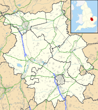
Maxey Castle is located in Cambridgeshire
Shown within Cambridgeshire
Type Fortified Manor House
Coordinates 52°39′54″N 0°19′55″W / 52.6651°N 0.3320°W / 52.6651; -0.3320Coordinates: 52°39′54″N 0°19′55″W / 52.6651°N 0.3320°W / 52.6651; -0.3320
Current
condition
Moat earthworks remain

Maxey Castle was a medieval fortified manor house castle in Maxey, Cambridgeshire, England.

Details

Maxey Castle was built around the 1370s by William Thorpe near the village of Maxey.[1] The castle had a double-moat, possibly designed as a flood defence, with a central keep within a bailey wall with corner towers.[1]

Today only the partial remains of the moats survive of the castle, which have scheduled monument status.[1]

See also

References

  1. ^ a b c Maxey Castle, Gatehouse website, accessed 21 May 2011.

Wikimedia Foundation. 2010.

Игры ⚽ Поможем решить контрольную работу

Look at other dictionaries:

  • Roanoke College — Infobox University name = Roanoke College image size = 161px motto = palmam qui meruit ferat ( let him who earns the palm wear it ) [http://web.roanoke.edu/About Roanoke/Traditions and Customs/Seal.htm] established = 1842 type = Private, liberal… …   Wikipedia

  • Список замков Англии — …   Википедия

  • Civil parishes in Cambridgeshire — A map of Cambridgeshire, showing the Districts, clockwise from the top left: Peterborough; Fenland; East Cambridgeshire; South Cambridgeshire; Cambridge; and Huntingdonshire. A civil parish is a subnational entity, forming the low …   Wikipedia

  • Peterborough — This article is about the city in the United Kingdom. For other uses, see Peterborough (disambiguation). Peterborough   City and unitary authority   …   Wikipedia

  • number game — Introduction       any of various puzzles and games that involve aspects of mathematics.       Mathematical recreations comprise puzzles and games that vary from naive amusements to sophisticated problems, some of which have never been solved.… …   Universalium

  • Clan Maxwell — Maxwell Crest badge Profile Region Lowland …   Wikipedia

  • Nayemont-les-Fosses — View of Nayemont les Fosses, with Saint Dié des Vosges in the background …   Wikipedia

  • Maps of castles in England by county — The castles displayed on each map are those listed in the List of castles in England for the corresponding county or area. Click on the red or green dot to display a detailed map showing the location of the castle. Green dots represent for the… …   Wikipedia

  • Darney — Darney …   Wikipedia

  • Northborough, Cambridgeshire — Northborough redirects here. For the town in Massachusetts, see Northborough, Massachusetts. Coordinates: 52°39′00″N 0°16′59″W / 52.65°N 0.283°W …   Wikipedia

Share the article and excerpts

Direct link
Do a right-click on the link above
and select “Copy Link”