- Mauna Kea State Recreation Area
-
Mauna Kea State Recreation Area 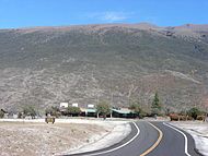
Mauna Kea in background

Coordinates 19°44′57″N 155°31′35″W / 19.74917°N 155.52639°WCoordinates: 19°44′57″N 155°31′35″W / 19.74917°N 155.52639°W Area 20.5 acres (8.3 ha) Governing body State of Hawaii Official website Mauna Kea State Recreation Area also known as Mauna Kea State Park, is a state of Hawaii protected area at the southern base of Mauna Kea.
The 20.5-acre (8.3 ha) park is administered by the Hawai'i Department of Land and Natural Resources. The park is located on Saddle Road (Route 200) 35 miles (56 km) west of Hilo, at 19°44′57″N 155°31′35″W / 19.74917°N 155.52639°W with about 6,500 feet (2,000 m) elevation. Facilities include restrooms, cabins and camping, trash cans, and a picnic area.[1] As of 2010[update] water improvements are planned.[2]
Wild pigs and sheep can be hunted in the area. The dry shrublands get cold at night due to the elevation. The nearby Bradshaw Field, a military airstrip on the Pohakuloa Training Area, and artillery practices can disturb the quiet of the site.[1]
On August 18, 2009 Senator Daniel Inouye and other officials held a ceremony at the park marking the third phase of the realignment of the Saddle Road. The first three phases improved 22 miles of the 55-mile (89 km) road, through the 8 miles (13 km) west of the park and 14 miles (23 km) east of the park.[3] On August 22, 2010, a fire broke out between the park and the training area. Dry conditions, strong winds, and steep terrain hampered fighting efforts, although military helicopters were used.[4] The fire burned for over a week, with traffic diverted to the older saddle road and the park closed down.[5]
See also
References
- ^ a b "Mauna Kea State Recreation Area". official state park web site. http://www.hawaiistateparks.org/parks/hawaii/maunakea.cfm. Retrieved August 23, 2010.
- ^ "Mauna Kea State Recreation Area". Hawai‘i Capital Improvement Projects for Recreational Infrastructure web site. http://hawaii.gov/dlnr/recreate/improvement-plans/hawaii/mauna-kea-state-recreation-area. Retrieved August 23, 2010.
- ^ Chelsea Jensen (August 19, 2009). "On the road to completion: Third phase of Saddle improvements done". West Hawaii Today. http://www.westhawaiitoday.com/articles/2009/08/19/local/local03.txt. Retrieved August 23, 2010.
- ^ Carolyn Lucas-Zenk (August 24, 2010). "Pohakuloa brush fire closes Saddle Road". West Hawaii Today. http://www.westhawaiitoday.com/articles/2010/08/24/local/local03.txt. Retrieved August 29, 2010.
- ^ "Pohakuloa brush fire closes Saddle Road". Hawaii 24/7. August 29, 2010. http://www.hawaii247.com/2010/08/29/mauna-kea-wildfire-60-percent-contained/. Retrieved August 29, 2010.
Protected Areas of Hawaii Federal Papahānaumokuākea Marine • World War II Valor in the PacificHakalau Forest • Hanalei • Hawaiian Islands • Huleia • James Campbell • Kakahaia • Kealia Pond • Kilauea Point • Kona Forest • Oahu ForestState Parks,
Monuments
Recreation Areas
and PreservesAkaka Falls State Park · Hapuna Beach State Recreation Area · Kalopa State Recreation Area · Kealakekua Bay State Historical Park · Kohala Historical Sites State Monument · Kona Coast (Kekaha Kai) State Park · Lapakahi State Historical Park · Lava Tree State Monument · MacKenzie State Recreation Area · Manuka State Wayside · Mauna Kea Ice Age Reserve · Mauna Kea State Recreation Area · Old Kona Airport State Recreation Area · Wailoa River State Recreation Area · Wailuku River State ParkKaua‘iMoloka‘iO‘ahuAhupua'a O Kahana State Park · 'Aiea Bay State Recreation Area · Diamond Head State Monument · Hanauma Bay Nature Preserve · He‘eia State Park · ‘Iolani Palace State Monument · Ka'ena Point State Park · Kaka'ako Waterfront Park · Kea'iwa Heiau State Recreation Area · Kewalo Basin · Kukaniloko Birthstones State Monument · La'ie Point State Wayside · Makapu‘u Point State Wayside · Malaekahana State Recreation Area · Nu'uanu Pali State Wayside · Pu'u o Mahuka Heiau State Monument · Pu'u 'Ualaka'a State Wayside · Royal Mausoleum State Monument · Sacred Falls State Park · Sand Island State Recreation Area · Ulu Pō Heiau State Monument · Wa'ahila Ridge State Recreation Area · Wahiawa Freshwater State Recreation AreaCategories:- Protected areas of Hawaii (island)
- Parks in Hawaii


Wikimedia Foundation. 2010.