Matamoros Municipality, Chihuahua

Matamoros Municipality, Chihuahua
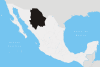
Matamoros
—  Municipality  —
Municipality of Matamoros in Chihuahua
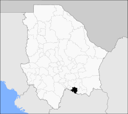
Matamoros is located in Mexico
Matamoros
Location in Mexico
Coordinates: 26°45′49″N 105°34′56″W / 26.76361°N 105.58222°W / 26.76361; -105.58222Coordinates: 26°45′49″N 105°34′56″W / 26.76361°N 105.58222°W / 26.76361; -105.58222
Country  Mexico
State Chihuahua
Municipal seat Mariano Matamoros
Area
 – Total 1,139.5 km2 (440 sq mi)
Population (2005)
 – Total 4,304
 – Density 3.8/km2 (9.8/sq mi)

Matamoros is one of the 67 municipalities of Chihuahua, in northern Mexico. The municipal seat lies at Mariano Matamoros (aka "Villa Matamoros"). The municipality covers an area of 1,139.5 km².

As of 2005, the municipality had a total population of 4,304.[1]

Geography

Towns and villages

The municipality has 46 localities. The largest are:

Name Population
Mariano Matamoros 2,256
El Veranito 509
Santa Rosalía 345
Ciénega de Ceniceros 312
Total Municipality 4,304

References


Wikimedia Foundation. 2010.

Игры ⚽ Нужно решить контрольную?

Look at other dictionaries:

  • Matamoros Municipality — There are several municipalities in Mexico called Matamoros: Matamoros Municipality, Chihuahua Matamoros Municipality, Coahuila Matamoros Municipality, Tamaulipas See also Matamoros (disambiguation) This disambiguation page lists articles about… …   Wikipedia

  • Matamoros, Tamaulipas — Matamoros   City   Heroica Matamoros …   Wikipedia

  • Chihuahua (state) — For other uses, see Chihuahua (disambiguation). Chihuahua Estado Libre y Soberano de Chihuahua   State   …   Wikipedia

  • Ocampo Municipality, Coahuila — Ocampo   Municipality   Municipality of Ocampo in Coahuila …   Wikipedia

  • Mariano Matamoros, Chihuahua — Mariano Matamoros   Town   …   Wikipedia

  • Municipalities of Chihuahua — The Mexican state of Chihuahua is divided into 67 municipalities (municipios) …   Wikipedia

  • Rio Grande — Infobox River river name = Rio Grande caption = Map of the Rio Grande Watershed. origin = southern Colorado, in Hinsdale County mouth = Gulf of Mexico; Cameron County, Texas, and Matamoros municipality, Tamaulipas basin countries = United States …   Wikipedia

  • Metropolitan areas of Mexico — Map showing the location of the Metropolitan Areas in Mexico. Metropolitan areas in Mexico have been traditionally defined as the group of municipalities that heavily interact with each other, usually around a core city.[1] In 2004, a joint… …   Wikipedia

  • Mexican ceramics — Woman selling pottery items at the Feria de Texcoco, Texcoco, Mexico State Ceramics and pottery in Mexico date back thousands of years before the Pre Columbian period, when ceramic arts and pottery crafts developed with the first advanced… …   Wikipedia

  • Mexico–United States border — The border between the United States and Mexico spans four U.S. states, six Mexican states, and has over twenty commercial railroad crossings …   Wikipedia

Share the article and excerpts

Direct link
Do a right-click on the link above
and select “Copy Link”