- Marion Street Bridge
-
Marion Street Bridge 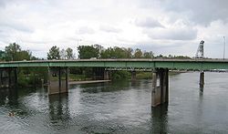
Carries Marion Street/
Oregon Route 22Crosses Willamette River Locale Salem, Oregon Maintained by Marion County Design Plate girder Opened 1954 Coordinates 44°56′45″N 123°02′33″W / 44.94583°N 123.0425°WCoordinates: 44°56′45″N 123°02′33″W / 44.94583°N 123.0425°W The Marion Street Bridge is an automobile bridge located in Salem, Oregon, United States. It spans the Willamette River to connect Salem and West Salem, and acts as a conduit for Oregon Route 22. The bridge carries vehicular traffic one way westbound. Traffic includes two lanes that flow onto the bridge from Marion Street, vehicles turning right from Commercial Street, and traffic from a quarter-loop on-ramp from Front Street that was added in 1981.[1] Construction began in December 1952 and the bridge opened in 1954, after taking nearly three years to complete.[2][3] The bridge was built to complement the Center Street Bridge, which switched from two-way traffic to eastbound-only, later expanding to four lanes in 1982.[1] At the time of its opening, the Marion Street Bridge was the longest bridge of its type west of the Mississippi River.[3]
See also
References
- ^ a b "Crossing the Willamette". mwvcog.org. http://www.mwvcog.org/transportation/skats/projects/WRCCSbrochure.pdf. Retrieved December 27, 2008.[dead link]
- ^ "History of Bridges". Salem River Crossing. http://www.salemrivercrossing.org/ProjectDocuments/TF_BridgeBrochure_MWVCOG_08.15.07.pdf. Retrieved December 29, 2008.
- ^ a b Lutz, Dick. "Salem History: Bridges". salemhistory.net. http://www.salemhistory.net/transportation/bridges.htm. Retrieved December 27, 2008.
External links
- Historic images of Marion Street Bridge from Salem Public Library
Crossings of the Willamette River Upstream
Center Street Bridge

Marion Street Bridge Downstream
Union Street Railroad BridgeCategories:- Bridges completed in 1954
- Buildings and structures in Salem, Oregon
- Bridges over the Willamette River
- Concrete bridges
- Plate girder bridges
- Transportation in Polk County, Oregon
- Transportation in Salem, Oregon
- Buildings and structures in Polk County, Oregon
- Road bridges in Oregon

Wikimedia Foundation. 2010.