- Marine Corps Air Station Kaneohe Bay
-
MCAS Kaneohe Bay 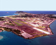
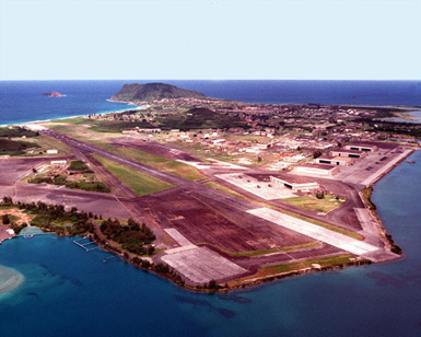
An overhead shot of MCAF Kaneohe Bay. IATA: none – ICAO: PHNG – FAA LID: NGF Summary Airport type Military Operator United States Marine Corps Serves Marine Corps Base Hawaii Location Kaneohe, Hawaii Built 1939 In use 1939-1949, 1952 - present Commander LtCol Jeffrey P. Pellegrino[1] Elevation AMSL 24 ft / 7 m Website Runways Direction Length Surface ft m 4/22 7,771 2,369 Asphalt Sources: Official website[2] and FAA[3] Kanehoe Naval Air Station During the Attack on Pearl Harbor, portions of Hangar 1 were destroyed. In 1987, the hangar and five sea plane ramps were designated a National Historic Landmark.

Nearest city: Kailua, Honolulu County, Hawaii Coordinates: 21°26′45″N 157°46′11″W / 21.44583°N 157.76972°WCoordinates: 21°26′45″N 157°46′11″W / 21.44583°N 157.76972°W Area: 41-acre (17 ha) Built: 1941 Architect: United States Navy Governing body: United States Marine Corps NRHP Reference#: 87001299[4] Significant dates Added to NRHP: May 28, 1987 Designated NHLD: May 28, 1987[5] Marine Corps Air Station Kaneohe Bay or MCAS Kaneohe Bay (ICAO: PHNG, FAA LID: NGF) is a United States Marine Corps airfield located within the Marine Corps Base Hawaii complex, formerly known as Marine Corps Air Facility (MCAF) Kaneohe Bay or Naval Air Station (NAS) Kaneohe Bay.[2] It is located two miles (3 km) northeast of the central business district of Kaneohe, in Honolulu County, Hawaii, United States. The airfield has one runway (4/22) with a 7,771 x 200 ft (2,369 x 61 m) asphalt surface.[3]
Contents
Resident units
- Marine Aircraft Group 24
- Patrol and Reconnaissance Wing Two
History
Fort Hase and NAS Kaneohe Bay
The United States Army acquired 322 acres (1.30 km2) of the peninsula when President Woodrow Wilson signed executive order 2900 establishing the Kuwaaohe Military Reservation. Little is known about the operations of the fort, however, at the end of World War I, the military property was leased for ranching. In 1939, Kuwaaohe was reactivated, subjected to many name changes to include Camp Ulupa’u, and eventually named Fort Hase.
Prior to and during World War II, Fort Hase grew from a humble beginning as a defense battalion to a major unit of the Windward Costal Artillery Command. Navy planners began to eye the peninsula in 1939 as the home of a strategic seaplane base. They liked the isolated location, the flat plains for an airfield and the probability of flights into prevailing trade winds. In 1939, the Navy acquired 464 acres (1.88 km2) of the peninsula for use of the PBY Catalina Patrol seaplanes for long-range reconnaissance flights. One year later, the Navy owned all of the Mokapu Peninsula except for Fort Hase.
On December 7, 1941, the Imperial Japanese Navy attacked the air station minutes prior to the attack on Pearl Harbor. Of the 36 Catalinas stationed here, 27 were destroyed and six others were damaged, along with 18 sailors who perished in the attack. The first Japanese aircraft destroyed in action were shot down at Kaneohe, along with Aviation Ordnanceman Chief Petty Officer John William Finn becoming one of the first Medal of Honor recipients of World War II for valor on that day.
During the war, the air station was a major training base in the Pacific Theater. The Fleet Gunnery School trained thousands of Navy gunners. There was a school for celestial navigation, sonar, aircraft recognition, and turret operations. Flight instructors also trained Navy and Marine Corps aviators in flight operations prior to being sent to a forward combat area. Following the war, Fort Hase had become a skeleton outpost and the air station consisted of limited air operations, a small security detachment, and a federal communications center.
Marine Operations
In 1949, the Navy decommissioned the air station. On January 15, 1952 the Marine Corps re-commissioned the idle airfield Marine Corps Air Station Kaneohe Bay, making it an ideal training site for a combined air/ground team. Station Operations and Headquarters Squadron supported flight operations until June 30, 1972, when Station Operations and Maintenance Squadron was commissioned in its place. SOMS served until it was disbanded on July 30, 1994. Marine Corps Air Facility Kaneohe Bay was formed on that date and continues today to serve the operational needs of the aviation community.
On May 28, 1987, the National Register of Historic Places listed "Kaneohe Naval Air Station" as a historic district and a National Historic Landmark.[6][7][5]
Following the 1993 Base Realignment and Closure Committee’s decision to close Naval Air Station Barbers Point, the base acquired 4 Navy P-3 Orion patrol squadrons and one SH-60 Seahawk Anti-Submarine squadron in 1999. Today there are almost 10,000 active duty Navy and Marine Corps personnel attached to the base.
The installation was re-designated as an Air Station (vice an Air Facility) in May 2009.[8] At the same time, the airfield was named for MajGen Marion Eugene Carl, and the Corps announced that new squadrons would be stationed there.
-

Old MCAS Kaneohe Bay insignia -
Old MCAS Kaneohe Bay patch
See also
References
- ^ Commanding Officer's biography on MCAS Kaneohe Bay website
- ^ a b MCAS Kaneohe Bay, official website, retrieved 2011-4-11
- ^ a b FAA Airport Master Record for NGF (Form 5010 PDF), effective 2007-10-25
- ^ "National Register Information System". National Register of Historic Places. National Park Service. 2008-04-15. http://nrhp.focus.nps.gov/natreg/docs/All_Data.html.
- ^ a b "Kaneohe Naval Air Station". National Historic Landmark summary listing. National Park Service. http://tps.cr.nps.gov/nhl/detail.cfm?ResourceId=2003&ResourceType=District. Retrieved 2008-07-04.
- ^ "NPS Form 10-900: National Register of Historic Places Inventory Nomination Form". National Register of Historic Places. National Park Service. June 17, 1986. http://pdfhost.focus.nps.gov/docs/NHLS/Text/87001299.pdf. Retrieved 21 March 2011.
- ^ "NPS Form 10-900; attached photos". National Register of Historic Places. National Park Service. June 17, 1986. http://pdfhost.focus.nps.gov/docs/NHLS/Text/87001299.pdf. Retrieved 21 March 2011.
- ^ "K-Bay gets new name, status". Honolulu Advertiser (Marine Corps Times). 2009-05-25. http://www.marinecorpstimes.com/news/2009/05/marine_hawaii_052309w/. Retrieved 2009-05-27.
External links
- Official website
- USMC Air Station Kaneohe Bay Overview & PCS Information (MarineCorpsUSA.org)
- Resources for this airport:
- AirNav airport information for PHNG
- FlightAware airport information and live flight tracker for PHNG
- NOAA/NWS latest weather observations for PHNG
- SkyVector aeronautical chart for NGF
- Airport information for PHNG (FAA: NGF) at World Aero Data. Data current as of October 2006.
- Airport information for PHNG (FAA: NGF) at Great Circle Mapper.
- Kaneohe Bay on GlobalSecurity.org
Army 
Air Force  BaseStation
Navy 
Marine Corps  BaseAir StationMarine Corps Air Station Kaneohe BayCampRangesMCTAB • PuuloaDecomissioned
Coast Guard 
U.S. National Register of Historic Places Topics Lists by states Alabama • Alaska • Arizona • Arkansas • California • Colorado • Connecticut • Delaware • Florida • Georgia • Hawaii • Idaho • Illinois • Indiana • Iowa • Kansas • Kentucky • Louisiana • Maine • Maryland • Massachusetts • Michigan • Minnesota • Mississippi • Missouri • Montana • Nebraska • Nevada • New Hampshire • New Jersey • New Mexico • New York • North Carolina • North Dakota • Ohio • Oklahoma • Oregon • Pennsylvania • Rhode Island • South Carolina • South Dakota • Tennessee • Texas • Utah • Vermont • Virginia • Washington • West Virginia • Wisconsin • WyomingLists by territories Lists by associated states Other Categories:- Historic districts in Hawaii
- United States Marine Corps air stations
- Military facilities in Hawaii
- Airports in Hawaii
- Buildings and structures in Honolulu County, Hawaii
- Transportation in Honolulu County, Hawaii
- Military facilities on the National Register of Historic Places in Hawaii


Wikimedia Foundation. 2010.