- Manuripi Province
-
Manuripi Location in Bolivia 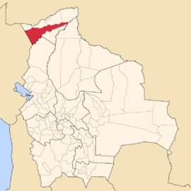
General Data Capital Puerto Rico Area 22,461 km² Population 8,230 (2001) Density 0.4 inhabitants/km² (2001) ISO 3166-2 BO.PA.MN Pando Department 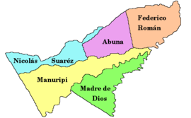
Manuripi is one of the five provinces of Pando Department in Bolivia and is situated in the department's north-western parts. Its name derives from Manuripi River which passes the province from West to East
Contents
Location
Manuripi province is located between 10° 49’ and 12° 30' South and between 66° 00' and 69° 14' West. It extends over a length of 370 km from Northeast to Southwest, and up to 100 km from Northwest to Southeast.
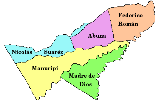
The province is situated in the Amazon lowlands of Bolivia and borders Abuná Province in the North, Nicolás Suárez Province in the Northwest, Peru in the West, La Paz Department in the South, Madre de Dios Province in the Southeast, Beni Department in the East, and Federico Román Province in the Northeast.
Population
The population of Federico Román Province has increased by 40 % over the recent two decades:
- 1992: 7,360 inhabitants (census)
- 2001: 8,230 inhabitants (census)
- 2005: 9,505 inhabitants (est.)[1]
- 2010: 10,164 inhabitants (est.)[2]
47.7 % of the population are younger than 15 years old. (1992)
98.0 % of the population speak Spanish, 0.4 % speak Quechua, and speak 0.2 % Aymara. (1992)
The literacy rate of the province's population is 75.4 %. (1992)
91.0 % of the population have no access to electricity, 68.5 % have no sanitary facilities. (1992)
84.4 % of the population are Catholics, 14.6 % are Protestants. (1992)
Division
The province comprises three municipalities:
- Filadelfia Municipality – 3,145 inhabitants (2005)[3]
- Puerto Rico Municipality – 4,003 inhabitants
- San Pedro Municipality – 1,082 inhabitants
Places of interest
References
- ^ Instituto Nacional de Estadística
- ^ Instituto Nacional de Estadística - Proyecciones
- ^ Instituto Nacional de Estadística
External links
- t_manuripi.htm General map of province
- manuripi.htm Detailed map of province towns and rivers
- Population data (Spanish)
- Social data (Spanish)
Pando Department Abuná · Federico Román · Madre de Dios · Manuripi · Nicolás Suárez
Categories:

Wikimedia Foundation. 2010.