- Manhood Peninsula
-
Coordinates: 50°44′46″N 0°47′28″W / 50.746°N 0.791°W
 Manhood Peninsula
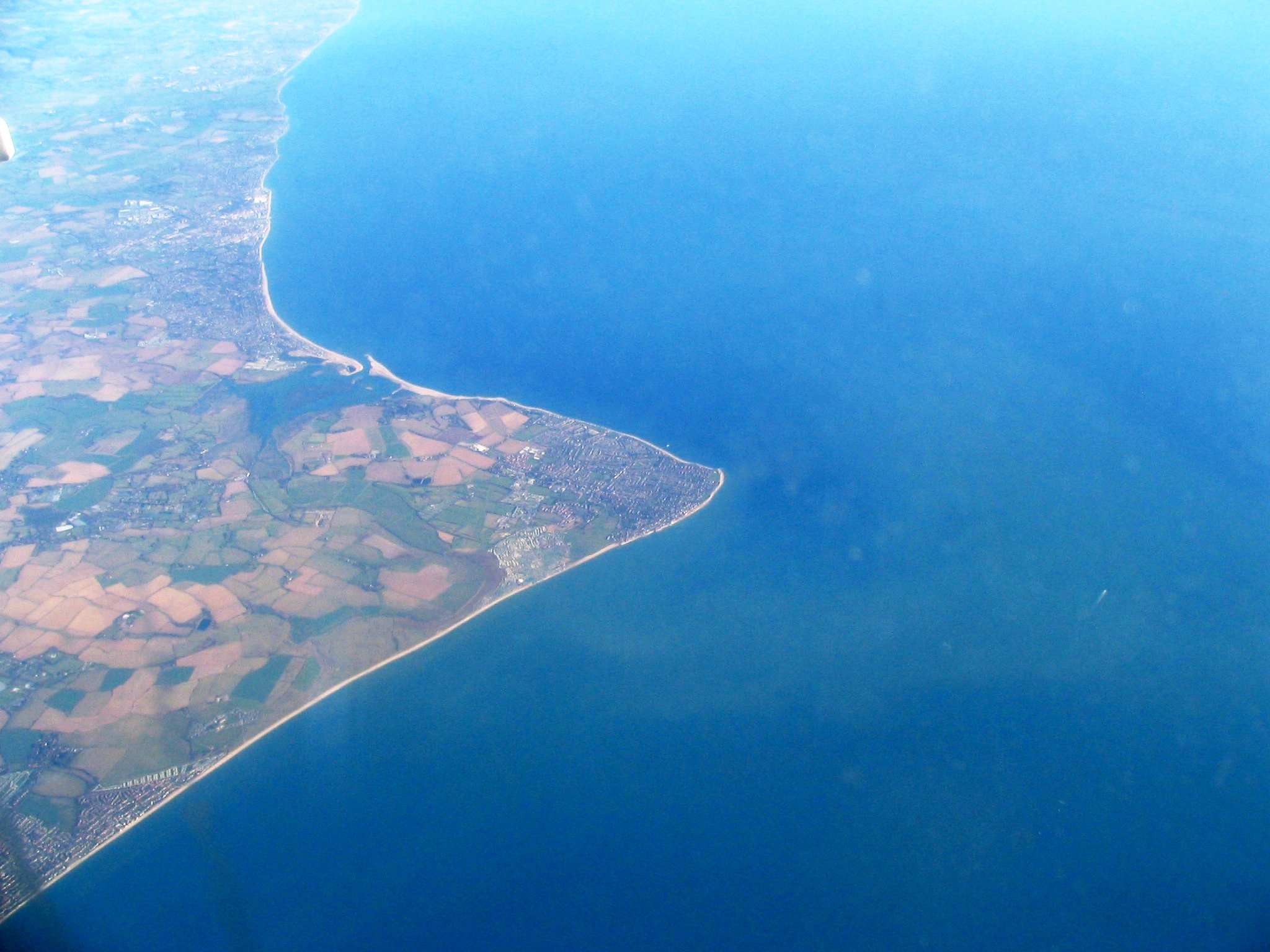
The Manhood Peninsula is the southernmost part of Sussex in England. It has the English channel to its south and Chichester to the north.
The peninsula is bordered to its west by Chichester Harbour and to its east by Pagham Harbour, its southern headland being Selsey Bill.[1]
Contents
Name
The name Manhood has had various spellings over the years including Manweb on the Armada map of 1587, Manhode on a map of 1663 and Manhope on Mordens map of 1695.[2] The name is probably derived from the Old English maene-wudu meaning "men's wood" or "common wood", in other words common land.[3] This woodland would have remained in common until 1793 when 693 acres (2.80 km2) were enclosed by Acts of Parliament.[3]
History
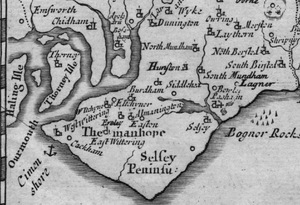 Section of Robert Mordens map of Sussex from 1695 with the Manhood Peninsula, shown as The manhope .
The Manhood Peninsula was formerly known as the Hundred of Manhood, in the Rape of Chichester.[1] The Rape was a county sub-division peculiar to Sussex.[4] In AD681 St Wilfrid landed in the land of the South Saxons and spent five years there evangilising them.[5] The Manhood was founded when the local Saxon King Cædwalla granted Wilfrid 87 hides of land in AD683, to build a monastery.[6]
After the Norman Conquest the area became a barony, by which tenure the Bishop of Chichester sat as a peer in parliament.[7]
The Hundred was an ancient unit of local administration.[8] At the time of the Domesday Survey, Sussex contained fifty nine hundreds.[9] The area of each hundred in Sussex would have been approximately 25 square miles (65 km2), quite small in comparison to other counties where the hundred could be as much as 200 square miles (520 km2) in area.[10] During Norman times the hundred would pay geld (a form of land tax) based on the number of hides.[11] To assess how much everyone had to pay, a clerk and a knight were sent by the king to each county, they sat with the sheriff of the county and a select group of local knights.[11] There would be two knights from each hundred. After it was determined what geld had to be paid, then the knights of the hundred and the bailiff of the hundred were responsible for getting the money to the sheriff, and the sheriff to the Exchequer.[11]
 Armada Map of the Selsey peninsula from a survey made in 1587. Note the "Hundred House in Manwed (Manhood)" at the top of map, with detail inset.
From the 10th century on the Manhood had its own court of justice and it also dealt with matters that a local authority of today would deal with, such as policing and highways.[8] At the time of the Domesday Survey the Hundred was known as the Hundred of Westeringes and Somerley with an Earl Roger Montgomery holding the Hundred of 'Westeringes' ( Wittering), containing Birdham (3½ hides), Itchenor (1 hide), Somerley in East Wittering (1 hide) and East Wittering (1 hide).[12] Roger Montgomery was one of the kingdoms most powerful lords, at the time, with extensive landholdings around the country including nearly all of what is now West Sussex.[13] The Bishop of Chichester (formerly of Selsey) held the Hundred of Somerley with 10 hides in Selsey, 12 in Sidlesham, and 14 in West Wittering.[12]
By the 12th century the two Hundreds became united in the one Hundred of Manhood and was a liberty of the Bishop of Chichester, consisting of the land originally given to St Wilfrid by Cædwalla.[6][12][14] The manor house for the Hundred of Manhood was situated just north of Sidlesham church.[15] In the year 1525, a claim was made for part of the Manhood by William, Earl of Arundel, based on his ownership of the manor of Almodington.[7] To settle the dispute a meeting was held at the Hundred court-house between Robert Sherborne, Bishop of Chichester and John Stilman, the Earl's counsel. The court found in the Bishops favour and Henry VIII's charter confirmed the boundary of the land, which coincided with those in St. Wilfrid's original charter.[7][16][17]
As lord of the hundred the Bishop of Chichester was expected to hold a court-leet annually, that all residents were bound to attend.[7] This continued till about 1835, and would have been held at the hundred-moot which is believed to have been at Hundredsteddle Farm, Somerley near Birdham.[12] According to The Placenames of Sussex, Somerley is the Old English for a clearing used in summer and an earlier version of steddle was probably staddle, the name Hundredsteddle would be a reference to the floor on which the Hundred court would have sat.[18][19]
In 1561 Elizabeth I passed an act that removed some of the Manhood parishes from the See of Chichester.[20][21] These parishes were eventually sold to lay proprietors and included Selsey, that a Sir William Morley purchased from the crown for £4100 in 1635.[20]
List of parishes in the Hundred of Manhood
In addition to the seven parishes listed above, the Hundred originally contained three others: East Itchenor, annexed to Birdham in 1441; Almodington, annexed to Earnley in 1526; and Bracklesham, largely washed away by the sea and finally united to East Wittering in 1518. For purposes of taxation the hundred was divided into four vill—Sidlesham, Selsey, Wittering, and Birdham.[12]
The Manhood today
The Hundred as a judicial and administrative unit was diminished by various acts of parliament in the 19th century.[22] The Manhood Peninsula still exists geographically and is administered by Chichester District Council with the villages and town on the peninsula also having their own local councils.[23]
Many organisations both commercial and non-commercial, that are based on the Manhood Peninsula have the name Manhood in their title.[24] Some organisations exist to deal with common issues and problems encountered by all on the Manhood, for example the Manhood Peninsula Partnership, which is a resident-inspired partnership of local communities, local and national government agencies, and other bodies involved in the Manhood thats purpose is to create a wider understanding of the issues facing the area and has forged a new way of working together for the benefit of the peninsula and its people.[25] Thus although the Manhood is not a political entity as in the days of the Hundred, todays parishes that make up the Manhood Peninsula still have a lot of common issues that bind them together.[25]
See also
- Hundred of Manhood and Selsey Tramway
- Manhood Community College
- List of hundreds of England and Wales
Notes
- ^ a b Peninsular Partnersip. Archaeology in the peninsula.
- ^ Heron-Allen. Selsey. p.11.
- ^ a b Brandon. South Saxons. pp.6-8
- ^ Salzman. The History of the County of Sussex. The Rape of Chichester. Introduction. pp. 1-2 .
- ^ Mee. A History of Selsey p.10
- ^ a b Kelly. Charters of Selsey. pp.85 - 91.
- ^ a b c d Horsfield.History of the County of Sussex. pp.32-33
- ^ a b Armstrong. History of Sussex pp.42-43
- ^ Brandon. South Saxons. Appendix A. The Domesday Hundreds of Sussex. pp.209-220. - notes and statistics given for the individual Sussex hundreds of Domesday Book.
- ^ Bartlett. England under the Normans. p.157.
- ^ a b c Bartlett. England under the Normans. pp.165 - 167.
- ^ a b c d e Salzmann. The hundred of Manhood: Introduction: A History of the County of Sussex. Vol 4. p.198
- ^ Horsfield. History of Sussex. pp.76 - 77
- ^ Free Dictionary Online. Liberty - In the English law, by liberty is meant a privilege held by grant or prescription, by which some men enjoy greater benefits than ordinary subjects. A liberty is also a territory, with some extraordinary privilege.
- ^ Mee. A History of Selsey p.16
- ^ Mee. History of Selsey. pp.3-4.The (boundary) ran from the entrance of Selsey Harbour (now called Pagham Harbour), round the coast to "Hormouth" at the entrance to Chichester Harbour (now West Wittering); then up the estuary to "Brimesdik" (683) or "Bremerdytch"(1525), (the stream dividing Birdham from Appledram); then eastwards to Wayflete, and from thens in circuit into Made-up-lane (now Jury Lane) and so eastward to Dammer-gate; and so along the dytch unto the said Unredisdytch, (now Bremere Rife, which runs south into Selsey Harbour).
- ^ Heron-Allen. Selsey. p.11. the lybertyes of the Manwode belonging to the Byshop of Chichester, beginneth at Uredisdytch and extendeth southward, to the havyn of Wyddering, now called Selsey Haven, extending westward as the course of the sea, to Hormouth Haven, now called West Widdering; and from thence northward it extendeth along to Viales-flete, now called Bosham-dytch; and so from thens upwarde the havyn, to Brunesdyke, now called Bremers-dytch; and from thens extendinge eastwarde to Wayflete, and thens in circuit into Made-up-lane, and so eastwarde to Dammer-gate; and so along the ditch unto the said Unredisdytch.
- ^ Stenton. Placenames of Sussex. p.79
- ^ Parish. A Dictionary of Sussex Dialect. The word steddle was quite common in Sussex various examples being: p.17. Bedsteddle - Bedstead; p.64. Jointsteddle - a stool framed by joinery work; p.83. Oxsteddle - Stabling or stalls for oxen; p.114. Steddle - a small side table or a temporary arrangement of boards and trestles.
- ^ a b Horsfied. History and Antiquities Vol II P.35
- ^ Mee. History of Selsey. p.19
- ^ " Hundred. Free Dictionary Online. Retrieved 10 Aug 2010
- ^ Chichester District Council.
- ^ BT. Portsmouth Phone Book 2009/2010
- ^ a b Manhood Peninsula Partnership Website
References
- Armstrong, J.R. (1961). A History of Sussex. Chichester, Sussex: Philimore. ISBN 08503318544.
- Bartlett, Robert (2000). J.M.Roberts. ed. England Under the Norman and Angevin Kings 1075 -1225. London: OUP. ISBN 9780199251018.
- Brandon, Peter (1978). The South Saxons. Chichester: Phillimore. ISBN 0850332400.
- Heron-Allen, Edward (1911). Selsey Historic and Prehistoric. Duckworth.
- Horsfield, Thomas Walker (1835 Facsimile Ed 2009). The History, Antiquities and Topography of the County of Sussex Vol II. Country Books. ISBN 978-1-906789-16-9.
- Kelly, S.E (1998). Anglo-Saxon Charters VI, Charters of Selsey. OUP for the British Academy}. ISBN 0-19-726175-2.
- Mee, Frances (1988). A History of Selsey. Chichester, Sussex: Philimore. ISBN 0850336724.
- Parish, William Douglas (1875). A Dictionary of the Sussex Dialect and Collection of Provincialisms in use in the County of Sussex. Lewes: Farncombe & Co..
- "Manhood Peninsula Partnership". Peninsular Partnership. http://www.peninsulapartnership.org.uk. Retrieved 13 July 2010.
- Salzman, L.F. " A History of the County of Sussex: Volume 4.". British History Online. http://www.british-history.ac.uk/source.aspx?pubid=287. Retrieved 14 July 2010.
- Stenton, Frank (1930). The Placenames of Sussex Vol. 6. London: University Press.
- "Chichester District Council". CDC. http://www.chichester.gov.uk/. Retrieved 21 July 2010.
- "The Free Dictionary". The Free Dictionary. http://legal-dictionary.thefreedictionary.com. Retrieved 25 July 2010.
Categories:- Geography of West Sussex
- History of West Sussex
- Anglo-Saxon England
- Hundreds of Sussex


Wikimedia Foundation. 2010.