Majerus Falls

Majerus Falls
Majerus Falls.jpg

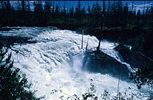
Majerus Falls is one of seven waterfalls on the Murtle River west of Murtle Lake in Wells Gray Provincial Park, east-central British Columbia, Canada.[1]

Majerus Falls is 12 m (39 ft) high and 90 m (295 ft) wide, a similar width to Dawson Falls downstream.[2]

The waterfall was discovered by Joseph Hunter, a surveyor working for the future Canadian Pacific Railway, on May 25, 1874. Hunter did not name the falls, but he did name the Murtle River and Murtle Lake for his birthplace in Scotland, Milton of Murtle, near Aberdeen. Majerus Falls and tiny Majerus Lake, north of here, are named for Michael Majerus, one of the first homesteaders in the Clearwater Valley. He built a cabin beside the Murtle River above Dawson Falls in 1912 and lived there until 1946.[2]

Access to Majerus Falls is by a hiking trail that starts at the Pyramid Campground. It skirts volcanic Pyramid Mountain and follows the north side of the Murtle River. The trail is 9.5 km (5.9 mi) long each way; allow about 3.5 hours to get to the falls.[2]

References

  1. ^ "Majerus Falls". BC Geographical Names. http://apps.gov.bc.ca/pub/bcgnws/names/3979.html. 
  2. ^ a b c Neave, Roland (2004). Exploring Wells Gray Park, 5th edition. Wells Gray Tours Ltd., Kamloops, BC. ISBN 0-9681932-1-8.


Wikimedia Foundation. 2010.

Игры ⚽ Нужно сделать НИР?

Look at other dictionaries:

  • Dawson Falls — Location Wells Gray Provincial Park Coordinates …   Wikipedia

  • Rick Majerus — College coach infobox Name = Rick Majerus Sport = Basketball | ImageWidth = Caption = DateOfBirth = birth date and age|1948|2|17 Birthplace = flagicon|United States Sheboygan Falls, Wisconsin DateOfDeath = Deathplace = College = Saint Louis Title …   Wikipedia

  • Murtle River — Dawson Falls The Murtle River is a river in east central British Columbia, Canada. It rises from a large unnamed glacier in the Cariboo Mountains at an elevation of 2,300 m (7,500 ft) and flows southwest for 18 km (11 mi) to… …   Wikipedia

  • Murtle Lake — Location British Columbia Coordinates 52°9′00″N 119°40′00″W /  …   Wikipedia

  • Polymorphism (biology) — Light morph Jaguar (typical) Dark morph or melanistic Jaguar (about …   Wikipedia

  • Clearwater River (British Columbia) — Clearwater River and Osprey Falls at outlet of Clearwater Lake The Clearwater River is the largest tributary of the North Thompson River, joining it at the community of Clearwater, British Columbia. The Clearwater rises from glaciers in the… …   Wikipedia

  • National Register of Historic Places listings in Stearns County, Minnesota — This is a list of properties on the National Register of Historic Places in Stearns County, Minnesota. Stearns County is located in central Minnesota. This National Park Service list is complete through NPS recent listings posted November 10,… …   Wikipedia

  • Doc Rivers — Head Coach Personal information Date of birth October 13, 1961 (1961 10 13) (age 50) Place of birth …   Wikipedia

  • Nenad Medić — Nenad Medic Medic after winning the $10,000 Pot Limit Hold em World Championship at the 2008 World Series of Poker. Nickname(s) Serb Hometown Niagara Falls, Ontario …   Wikipedia

  • Sheboygan, Wisconsin — Infobox Settlement official name = Sheboygan, Wisconsin nickname = Bratwurst Capital of the World [http://www.infoplease.com/spot/roadtrip1.html] , The City of Cheese, Chairs Children [http://www.sheboygan.lib.wi.us/pages/spfeature.html] image… …   Wikipedia

Share the article and excerpts

Direct link
Do a right-click on the link above
and select “Copy Link”