- Maine State Route 88
-
State Route 88
Route information Maintained by MaineDOT Length: 8.41 mi[1] (13.53 km) Major junctions South end:  U.S. Route 1 in Falmouth
North end: U.S. Route 1 in YarmouthLocation Counties: Cumberland Highway system ←  SR 86
SR 86SR 89  →
→State Route 88 is a state highway in southern Maine, United States. It runs south to north for just over 8.41 miles (13.53 km) miles, from U.S. Route 1 in Falmouth to U.S. Route 1 in Yarmouth. It runs to the east of Route 1, and its speed limit is 35 mph, whereas that of Route 1 is 45-50 mph north of Bucknam Road. Over its course, its furthest distance from Route 1 is about 0.5 miles (0.80 km). This occurs in its Falmouth Foreside section.
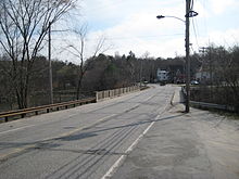 Route 88 in Yarmouth, looking south. This section of the highway is named Spring Street.
It is connected to Route 1 directly on three occasions — by (heading northward) Depot Road in Falmouth, Johnson Road in Falmouth Foreside, and Powell Road in Cumberland Foreside — before it links up with it again at Route 88's northern terminus. It is also connected to Route 1 indirectly, by a ramp, via Tuttle Road in Cumberland Foreside. Its name changes four times en route. It is Foreside Road between Route 1 and the Yarmouth town line (mile 6.02), at which point it becomes Lafayette Street. It then becomes East Main Street just before the Royal River falls (mile 7.6), before finishing as Spring Street (mile 7.9).
"Herbie", New England's oldest and largest elm tree for the final thirteen years of its existence, stood on Route 88 (East Main Street) in Yarmouth, at its intersection with Yankee Drive, between 1793 and 2010.
Route 88 is mostly residential, although businesses are located on it at several points. These include (again heading northward) Portland Country Club, Skillins garden center and the Falmouth Sea Grill (all in Falmouth); Town Landing Market (which was once featured in a national Coca-Cola commercial) (Falmouth Foreside); and the Lower Falls Landing plaza (Yarmouth). Each of these examples are situated on the northbound (eastern) side of the highway.
Gallery
-
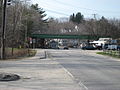
The I-295 overpass on the Lafayette Street section of Route 88
-

The East Main Street section of Route 88 was home to "Herbie", New England's oldest and largest elm tree
References
Categories:- State highways in Maine
- Transportation in Cumberland County, Maine
- Northeastern United States road stubs
-


Wikimedia Foundation. 2010.