- Dunhuang Star Chart
-
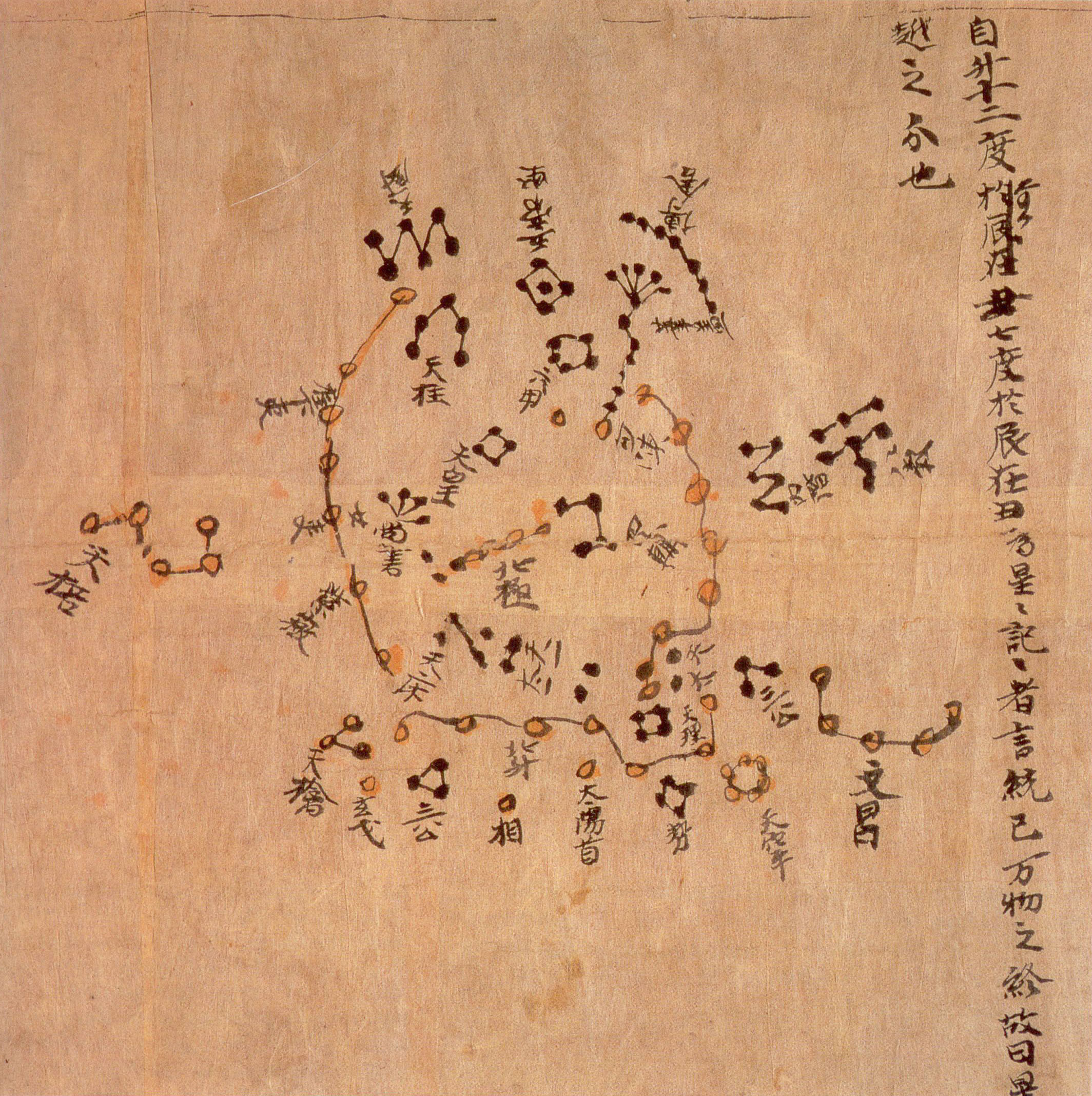
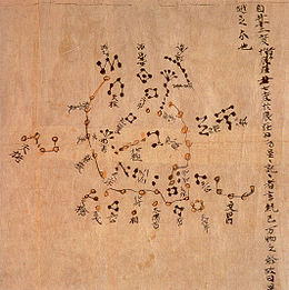 Detail of the Star Map from the Tang Dynasty showing the North Polar region (British Library Or.8210/S.3326). This map was made approximately in the year 700,[1] around the reign of Emperor Zhongzong of Tang (705-710). Constellations of the three schools were distinguished with different colors: white, black and yellow for stars of Wuxian, Gan De and Shi Shen respectively. The whole set of star maps contained 1,300 stars
The Dunhuang map or Dunhuang Star map is one of the first known graphical representation of stars from ancient Chinese astronomy, dated to the Tang Dynasty (618–907). Prior to this map, many of the star information mentioned in historical Chinese texts had been questioned.[2] The map provides a graphical verification of the star observations, and are part of a series of pictures on one of the Dunhuang manuscripts. The astronomy behind the map is explained in an educational resource posted on the website of the International Dunhuang Project, where much of the research on the map has been done.[3] The Dunhuang Star map is to date the world's oldest complete perserved star atlas.[4]
Contents
History
The scroll was discovered among the many manuscripts in the Mogao Caves by Chinese Taoist Wang Yuan-lu in the 1900s.[5] One of the first public mentionings of this script in Western studies was from Joseph Needham's 1959 version of the book Science and Civilisation in China. Since that time only a few publications have been devoted to the map, nearly all being Chinese publications.[2]
Colors
The symbols for the stars are divided into three different groups. They groups are presented in three colors presenting the "Three Schools of Astronomical tradition".[2]
Color Chinese Astronomer Comments Black Gan De (甘德) Red Shi Shen (石申) White Wu Xian (巫咸) There have been inconsistencies in his works. He is generally known as the astronomer who lived before Gan and Shi.[6] Yellow Others References
- ^ Xi, Zezong. "Chinese Studies in the History of Astronomy, 1949-1979," Isis (Volume 72, Number 3, 1981): 456–470. Page 464.
- ^ a b c Whitfield, Susan. [2004] (2004). The Silk Road: Trade, Travel, War and Faith. British Library Staff. Serindia Publications. ISBN 1932476121.
- ^ http://idp.bl.uk/education/astronomy/index.html.
- ^ Jean-Marc Bonnet-Bidaud, Dr Françoise Praderie and Dr Susan Whitfield. "The Dunhuang Chinese Sky: A Comprehensive Study Of The Oldest Known Star Atlas". http://idp.bl.uk/education/astronomy_researchers/index.a4d. "The Dunhuang star atlas is one of the most spectacular documents of the history of astronomy. It is a complete representation of the Chinese sky including numerous stars and asterisms depicted in a succession of maps covering the full sky (Figure 1). Apart its aesthetic appeal, the document found on the Silk Road is remarkable as it is the oldest star atlas known today from any civilization."
- ^ International Dunhuang Project.bl.uk
- ^ Peng, Yoke Ho (2000). Li, Qi and Shu: An Introduction to Science and Civilization in China. Courier Dover Publications. ISBN 0486414450
See also
Categories:- Chinese astronomy
- British Library oriental manuscripts
- Chinese manuscripts
- Star atlases
Wikimedia Foundation. 2010.