- Dobra, Opole Voivodeship
-
For other places with the same name, see Dobra (disambiguation).
Dobra
Dobrau— Village — 

 Dobra
Dobra
DobrauCoordinates: 50°27′4″N 17°54′1″E / 50.45111°N 17.90028°E Country  Poland
Voivodeship Opole County Krapkowice Gmina Strzeleczki Population 741 Dobra [ˈdɔbra], German Dobrau is a village in the administrative district of Gmina Strzeleczki (Gemeinde Klein Strehlitz), within Krapkowice County, Opole Voivodeship, in region of Upper Silesia in southwestern Poland.[1] It lies approximately 3 kilometres (2 mi) south-east of Strzeleczki, 6 km (4 mi) west of Krapkowice, and 25 km (16 mi) south of the regional capital Opole.
Before 1945 the area was part of Germany (see Territorial changes of Poland after World War II). Since 2006 the village, like the surrounding commune, has been officially bilingual in German and Polish.
The village has a population of 741 inhabitants. The nearby hamlet of Nowy Bud (Neubude), with a population of 82 people, is administered by this village.
History
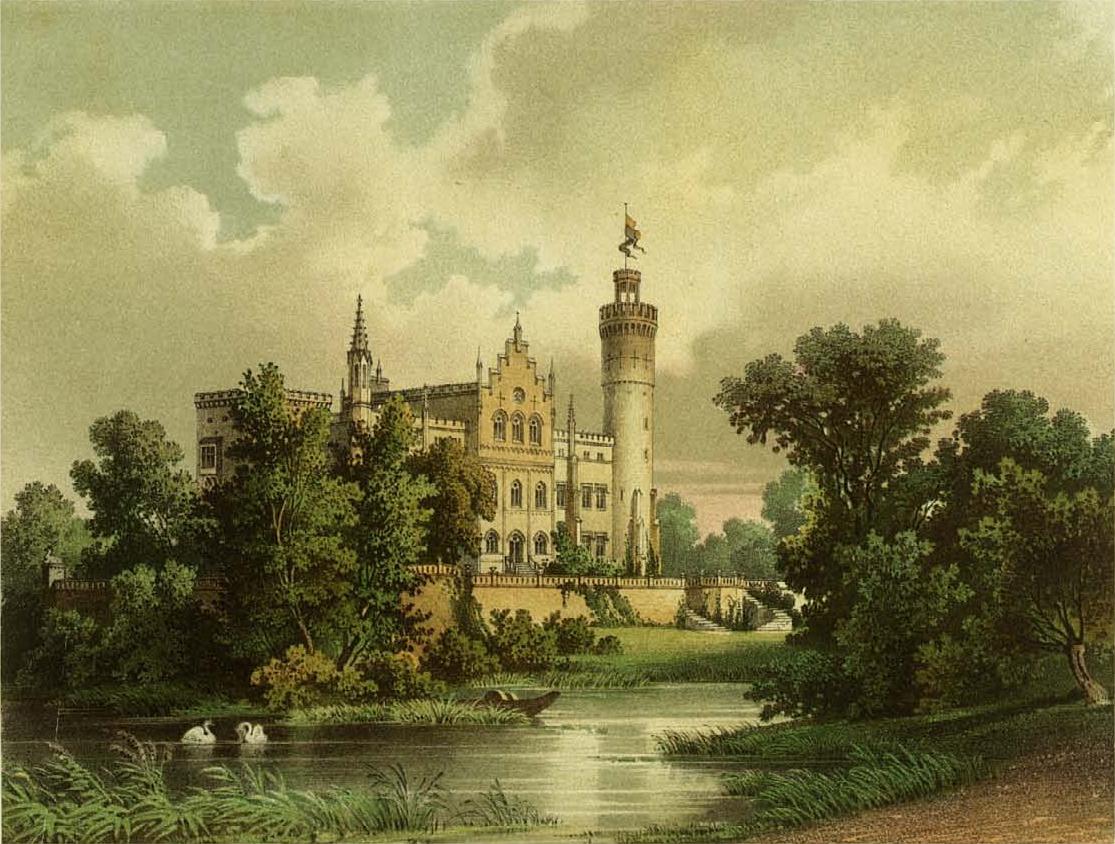
 Schloss Dobrau in the 19th century
 Schloss Dobrau
Dobrau is one of the oldest towns in the region, first mentioned in 1258. The name of the town derives from a Slavic word for "good", and referred to the fertile soil of the area. Since 1780 the village was in the possession of Count Heinrich Seherr-Thoss, one of the biggest landowners in Silesia, who had a castle nearby.[2] In 1867 the Catholic church was built with a donation from Countess Olga Seherr-Thoss. On the outside of the church is the tombstone of the knight Kasper Rogowski (d.1611), surrounded by eight heraldic crests.
In the Upper Silesia plebiscite of 20 March 1921 419 villagers voted to remain with Germany and 76 voted to join the newly created state of Poland. In the Dobrau Gutsbezirk, the local municipal council, 80 people voted for Germany and six for Poland.[3] As a result, Dobrau remained in Germany. In 1933 the village had grown to 796 inhabitants. On 21 July 1936 the town was renamed Burgwasser. Before 1945 it belonged to the district of Landkreis Neustadt O.S. During WWII the village was partially destroyed, first from 25-27 January and then again on 19 March 1945, when the historic palace was burned by the advancing Red Army.
In 1945 Silesia was given to Poland and the German population of Dobrau was largely expelled, dramatically reducing the town's population; it has not since reached its former size. The village was renamed Dobra and annexed to the newly created Silesian Voivodeship. In 1950 it was reassigned to Opole Voivodeship, and in 1999 reassigned from Prudnik County (formerly Neustadt O.S.) to Krapkowice County. On 17 May 2006 the entire commune of Strzelecki/Klein Strehlitz was declared bilingual in German and Polish, and on 24 November 2008 the old name German name Dobrau was also made official.
Near the village are the ruins of the neogothic Schloss Dobrau, built in 1720 for the Sehher-Thoss family and rebuilt 1857-60. The palace gardens were designed by Gustav Meyer, architect of many of Berlin's finest gardens, and contain many fine old trees. The palace, destroyed by the Russian army in 1945, is now in private hands and being renovated.
References
- ^ "Central Statistical Office (GUS) - TERYT (National Register of Territorial Land Apportionment Journal)" (in Polish). 2008-06-01. http://www.stat.gov.pl/broker/access/prefile/listPreFiles.jspa.
- ^ "Official website" (in Polish). http://www.strzeleczki.pl/cms/php/strona.php3?cms=cms_strze&lad=a&id_dzi=11&id_dok=11&id_men=11&powrot=1&slowo_szuk=&gdzie_szuk=&id_men_szuk=0.
- ^ Results of the Upper Silesia plebiscite (in German)
Seat StrzeleczkiOther villages Categories:- Villages in Krapkowice County
- Krapkowice County geography stubs


Wikimedia Foundation. 2010.