- Subdivisions of Belfast
-
The subdivisions of Belfast are a series of divisions of Belfast, Northern Ireland that are used for a variety of cultural, electoral, planning and residential purposes.
The city is traditionally divided into four main areas based on the cardinal points of a compass, each of which form the basis of constituencies for general elections: North Belfast, East Belfast, South Belfast, and West Belfast. These four areas meet at Belfast city centre. The second traditional divide is that formed by the River Lagan, with the northern bank of the River being part of County Antrim, while the southern bank is part of County Down.
The city's subdivisions reflect the divided nature of Northern Ireland as a whole, with areas tending to be highly segregated, especially in working-class neighbourhoods. Walls known as peace lines, originally erected by the British Army after August 1969, divide fourteen inner city neighbourhoods.[1]
Contents
Townlands
Main article: List of townlands in BelfastThe townlands of Belfast are the oldest surviving land divisions in the city. The city's townlands are split between the two traditional Counties by the River Lagan, with those townlands north of the river generally in County Antrim, while those on the southern bank are generally part of County Down. Most of these townlands are older than the city itself, and most of their names are derived from the Irish language. As the city grew, these once-rural townlands were built upon and their boundaries became obscured. However, many of the city's streets, roads and housing estates have been named after them.
Electoral Wards
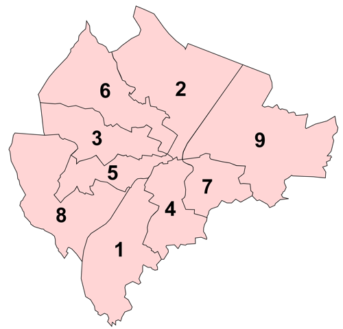
 Map showing location of Distirct Electoral Areas: 1: Balmoral; 2: Castle; 3: Court; 4: Laganbank; 5: Lower Falls; 6: Oldpark; 7: Pottinger; 8: Upper Falls; 9: Victora
 Main article: Electoral wards of Belfast
The electoral wards of Belfast are subdivisions of the city, used primarily for statistics and elections. Belfast has had 51 wards since May 1973, which were revised in May 1985 and again in May 1993. Wards are the smallest administrative unit in Northern Ireland and are set by the Local Government Boundaries Commissioner and reviewed every 8-10 years.[2]
In elections to Belfast City Council, the 51 wards are split into nine District Electoral Areas (DEAs), each of which contains between five and seven wards, with the number of councillors it elects equal to the number of wards it contains. The current DEAs are:
- Balmoral (6 wards)
- Castle (6 wards)
- Court (5 wards)
- Laganbank (5 wards)
- Lower Falls (5 wards)
- Oldpark (6 wards)
- Pottinger (6 wards)
- Upper Falls (5 wards)
- Victoria (7 wards)
Constituencies
Belfast's electoral wards are used to create constituencies for elections to the Northern Ireland Assembly and the House of Commons of the United Kingdom. These constituencies are coterminous and are created by amalgamating wards into larger areas, with the city's 51 wards split between the four 'Belfast' constituencies, each of which contains between 11 and 14 wards, although these also contain wards from bordering local authorities. These constituencies follow the tradition of referring to parts of Belfast by the four cardinal directions:
Belfast East
Belfast North
Belfast South
Belfast West
Cultural Quarters
Main article: Belfast QuartersThe Belfast Quarters refer to a number of distinctive cultural zones within the city of Belfast, whose identities have been developed as a spur to tourism and urban regeneration. These "quarters" differ from the districts into which Belfast is divided.
The term "quarter" does not refer to one fourth (or one quarter) of the city, nor is every area in the centre of Belfast part of one of the quarters. Instead, each "quarter" reflects something about a neighbourhood's history and locale, with the "Quarter" label being something that has come into general use in recent years.[3]
The quarters are as follows:
- Cathedral Quarter
- Gaeltacht Quarter
- Linen Quarter
- Market Quarter
- Queen's Quarter
- Smithfield Market and Library Quarter
- Titanic Quarter
Postcodes of Belfast
Main article: BT postcode areaBelfast city centre is divided by two postcodes, BT1 for the area lying north of the City Hall, and BT2 for the area to its south. The industrial estate and docklands share BT3. The rest of the Greater Belfast postcodes are set out in a clockwise system. Although BT stands for Belfast, it is used across the whole of Northern Ireland.[4]
Belfast City Centre:
- BT1 North of Belfast City Hall
- BT2 South of Belfast City Hall
- BT3 Industrial district
East & South East of Belfast City Hall:
- BT4 East Belfast
- BT5 East Belfast / Castlereagh
- BT6 East Belfast / Castlereagh
South & South West of Belfast City Hall:
- BT7 South Belfast
- BT8 South Belfast
- BT9 South Belfast
West South West & West of Belfast City Hall:
- BT10 South Belfast
- BT11 West Belfast
- BT12 West Belfast
- BT17 South West Belfast / Dunmurry
West North West & North of Belfast City Hall:
- BT13 West Belfast
- BT14 North Belfast
- BT15 North Belfast
Other areas of Belfast
General
Housing estates
Streets and Roads
- Ballygowan Road
- Cluan Place
- Donegall Road
- Falls Road
- Lisburn Road
- Malone Road
- Ormeau Road
- Sandy Row
- Shankill Road
- Shaw's Road
- Short Strand
- Stranmillis Road
- Westlink
- Whitewell Road
References
- ^ Margrethe C. Lauber. Belfast's Peacelines: An Analysis of Urban Borders, Design and Social Space in a Divided City. Archived from the original on 2007-02-08. http://web.archive.org/web/20070208064520/http://www.mspacenyc.com/belfast.study.html. Retrieved 2007-05-18.
- ^ "Modern Administrative Boundaries". Ordinance Survey Northern Ireland. http://www.osni.gov.uk/index/mapstore/admin_boundaries.htm. Retrieved 12 June 2011.
- ^ It was first said at the Ireland-US Council and Ireland Fund's Winter Week Conference in Palm Beach, USA in February 2006 that Belfast was once a city of two halves, but is now a city of seven quarters.
- ^ "The UK Postcode System". List Masters. 2005. http://www.listmasters.co.uk/postcodes.php. Retrieved 2007-06-12.
Categories:
Wikimedia Foundation. 2010.