- Old districts of Yerevan
-
The Districts of Yerevan refers to administrative divisions of Yerevan, including districts and neighborhoods.
Contents
Old districts
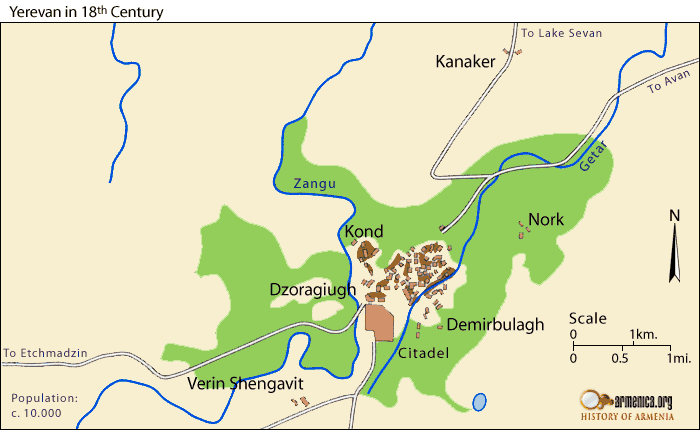
 Yerevan in the 18th century.
Since the 17th century Yerevan, without the fortress and nearby villages (Noragyugh, Dzoragyugh and Nork) was divided into three main quarters (mahlans):
- Shahar (The Old City),
- Demir-Bulagh (Karahank)
- Kond (Tapabash).
The market (Ghantar) was separate, between Kond and Shahar.
Shahar
Shahar (Persian: شهر šahr) was the oldest and biggest quarter of Yerevan. It located in the north-eastern part of the city, between Amiryan St. and Khorenatsi St. Probably, it was populated since ancient times, during the Kingdom of Urartu. During later centuries it was destroyed many times, but it was always populated. First time it was mentioned as “old Yerevan” or “the old city of Yerevan” by bishop Pilipos of Bjni in 1631. “Բազում որոնմամբ խուզեալ գտաք, զգանձս զայս անգին ի հին քաղաքն Երեւան՝ բազում ժամանակաւ գերի տարեալ ումեք իբրեւ եօթանասնօք”[1][2] “…after many searches I found it [the Bible] in the old city of Yerevan…”
Kond
Kond (Armenian: Կոնդ), so-named because of its high position, was called Tapabashi (Turkish and Azerbaijani for "top of the hill") during the period of Persian rule. Kond located in the western part of Yerevan. According to Hovhannes Shahkhatunyants, an Armenian historian, Kond located in the western and southern hillsides and foot of a rocky hill with similar name. Its western border was Hrazdan River, and the northern border was the Kozern Cemetery. Kond, alike as Shahar, was populated by Armenians. The population of Kond became multiethnic, when about 100 Armenian Boshas moved to Kond.[3]
Demir-Bulagh (Karahank)
The third large quarter was Demir-Bulagh (Turkish: Demir Bulağ, meaning “iron souce”) or Karahank (Armenian: Քարահանք, meaning "rock quarry" - there was a quarry of tufa and basalts there). It located in the south-eastern Yerevan. This district was inhabited, comparatively, later than other districts. Firstly, a quarry located here and was not inhabited. Later, Karahank was inhabited with newcomer Tatars (Azerbaijanis) and became part of Yerevan forming a separate district.[4][5]. Demir-Bulagh become crowded in 17th century, when terrified of the Persian invasions, many Turks from Nakhichevan moved to the areas north to the Yerevan Fortress. The majority of the population of the district were Muslims, few Armenians lived here. Because there was a spring with composition of the iron, it was called
Ghantar (the market)
The word Ghantar (Armenian: Ղանթար, meaning "big scales in a marketplace", from Arabic: قنطار, qinṭār). This quarter was the active and business center of old Yerevan. Ghantar belonged to the City Administration. Later, in place of Ghantar was built a close market and was called Ghantar. In 1938 in the place of Ghantar was built the Children's Park (it was called Kirov Park during the Soviet erav).
Expansion in the mid-19th century
 The City of Yerevan, 1827
After Erivan was taken over by the Russian troops in 1827, the city was expanded.
Thus, in the mid-19th century Yerevan had 7 districts:
- Shahar,
- Kond,
- Demir-Bulagh,
- Dzoragyugh,
- Nor tagh,
- Shen tagh and
- Nork.
About Shahar, Kond and Demir-Bulagh see above. Yerevan has been expanded at the expense of two surrounding villages: Dzoragyugh and Nork.
Dzoragyugh
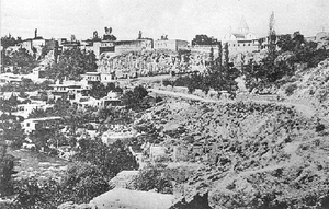 In the right side at the edge of the cliff overlooking the valley St. Sarkis Church. The upper terrace of the slope occupied houses, steps down to the Hrazdan River. Along the coast, near the river, concentrated production facilities, which attract the attention of simple silhouettes volumes with flat roofs.
Dzoragyugh (Armenian: Ձորագյուղ, Dara-kend in Turkish and Azerbaijani) was a suburb and later a district of Yerevan. It located in the Hrazdan gorge, in the left steep coast. During the Persian rule it was officially translated as Dara-kend. According to Zakaria Sarkavag this village - which before becaming a district of Yerevan was a suburban village - was called Khnkelo dzor.<Zakaria Sarkavag, Պատմագրութիւն (History), volume II, pp. 32, 51>. According to Simeon Yerevansti this village was called with two names: Dzoragyugh and Khnkadzor.[6] The Surb Sargis Church located in Dzoragygh and commonly was called the Church of Dzoragyugh. Dzoragyugh was called Khnkadzor or Khnkelo, because it was Yerevan’s bishop’s seat, the word “khunk” means ‘incense’ in Armenian. The population of Dzoragyugh was completely Armenian. Dzoragyugh had three smaller neighborhoods:
- Verin tagh (Վերին թաղ, “Upper district”) or Karapi tagh (Քարափի թաղ, “District of Bluff”) located in the left upland of Hrazdan, north-west from the fortress, in the surrounding area of the St. Sargis church.
- Storin tagh (Ստորին թաղ, “Lower district”) or Dzori tagh (Ձորի թաղ, “District of Gorge”) located in the left side of Hrazdan, in a precipitous gorge.
- The district of Karbi (Կարբիի թաղ) was, probably, the southern continuation of Storin tagh. In the district of Karbi lived villagers of the Karbi village of the Aragatsotn province. They moved there, because their village was destroyed.[7]
Nork
Nork (Armenian: Նորք, Turkish: Çömlekçi, meaning ‘potter’) was the second suburb villages of Yerevan, that became its part, it was in 1830s. Because the pottery was common labor, the Turks called it Cholmakci (Çömlekçi). The population was completely Armenian. They were working in agriculture, vegetable-growing, farming, and pottery. There were smaller districts (mahlans) in Nork, too. Though Nork was inhabited since ancient times, but it was mentioned comparatively late.[8] There were two churches in Nork: Surb Astvatsatsin and Surb Simeon Tseruni (19th century).
And other two new districts were built: Nor tagh and Shen tagh.
Nor tagh
Nor tagh (Armenian: Նոր թաղ, meaning “new district”) located in the eastern part of Kond, in the surrounding are of the Hovhannes Tumanyan House-Museum. It was called ‘new’, because many immigrants from Atropatene were moved here after the 1828 Treaty of Turkmenchay. During the Persian rule, in the place of the Nor tagh were the Gardens of the Sardars, called Khanlubagh (Persian: باغ خان)
Shen tagh
Shen tagh (Armenian: Շեն թաղ) located in the surrounding areas of the English Park.
See also
- History of Yerevan
- Yerevan
- Erebuni Fortress
- Armenian Oblast
- Erivan Governorate
- Khanate of Erevan
- History of Armenia
References
- ^ H. Tashyan, List of manuscripts "(Ձեռագրաց ցուցակ)", p. 260
- ^ "Handes Amsorya" («Հանդէս ամսօրեայ»), 1934, № 329 — 330
- ^ Hovhannes Shahkhutyants, Ստորագրութիւն կաթուղիկէ Էջմիածնի և հինգ գաւառացն Արարատայ, volume II, p. 146
- ^ I. Chopin, Historical monuments of the Armenian Oblast (Исторический памятник Армянской области), p. 464
- ^ Yervand Shahaziz, The Old Yerevan (Հին Երևանը), pp. 173—174
- ^ Simeon of Yerevan, Jambr (Ջամբռ), p. 204
- ^ Yervand Shahaziz, The Old Yerevan (Հին Երևանը), pp. 174-175
- ^ Ghevont Alishan, Ayrarat (Այրարատ), p. 293
- Albert Parsadanyan. Intelligence Warehouse-2. Yerevan, VMV-Print, 2005, p. 150-152.
- (Armenian) Կամսար Ավետիսյան. ՀԱՅՐԵՆԱԳԻՏԱԿԱՆ ԷՏՅՈՒԴՆԵՐ - ԵՐԵՎԱՆԻ ՄԻԿՐՈՏՈՊՈՆԻՄԻԿԱՆ. Երևան, «Սովետական գրող» հրատարակչություն, 1979
- (Armenian) Կամսար Ավետիսյան. ՀԱՅՐԵՆԱԳԻՏԱԿԱՆ ԷՏՅՈՒԴՆԵՐ - ՀԱՅՐԵՆԻՔՈԻՄ ՎԵՐԱՀԱՍՏԱՏՎԱԾ ՏԵՂԱՆՈՒՆՆԵՐ. Երևան, «Սովետական գրող» հրատարակչություն, 1979
External links
Categories:- Old Yerevan


Wikimedia Foundation. 2010.