- Dinh Lap District
-
Đình Lập District — District — Country  Vietnam
Region Northeast Province Lang Son Province Capital Dinh Lap Area – Total 456.8 sq mi (1,183 km2) Population (2003) – Total 28,125 Time zone UTC + 7 (UTC+7) Dinh Lap (Vietnamese: Đình Lập) is a district (huyện) of Lang Son Province in the Northeastern region of Vietnam.
As of 2003 the district had a population of 28,125.[1] The district covers an area of 1,183 km². The district capital lies at Dinh Lap.[1]
Administrative divisions
Đình Lập, Nông Trường Thái Bình, Lâm Ca, Đồng Thắng, Bắc Lãng, Châu Sơn, Cường Lợi, Thái Bình, Đình Lập, Bính Xá, Kiên Mộc, Bắc Xa.
References
- ^ a b "Districts of Vietnam". Statoids. http://www.statoids.com/yvn.html. Retrieved March 23, 2009.
 Districts of Northeast Vietnam (Dong Bac)
Bac Giang province Bac Giang · Hiep Hoa · Lang Giang · Luc Nam · Luc Ngan · Son Dong · Tan Yen · Viet Yen · Yen Dung · Yen Tha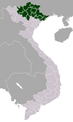
Bac Kan province Cao Bang province Cao Bang · Bao Lac · Bao Lam · Ha Lang · Ha Quang · Hoa An · Nguyen Binh · Phuc Hoa · Quang Uyen · Thach An · Thong Nong · Tra Linh · Trung KhanhHa Giang province Lang Son province Lao Cai province Phu Tho province Quang Ninh province Ha Long · Ba Che · Binh Lieu · Co To · Dam Ha · Dong Trieu · Hai Ha · Hoanh Bo · Tien Yen · Van Don · Yen HungThai Nguyen province Tuyen Quang province Yen Bai province Categories:- Districts of Lang Son Province
- Northeast Vietnam geography stubs

Wikimedia Foundation. 2010.