- Dien Bien Dong District
-
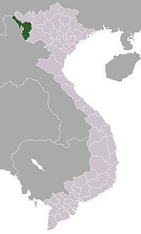
Điện Biên Đông District — District — District location in northern Vietnam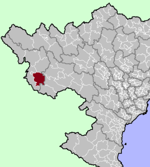
Coordinates: 21°15′N 103°14′E / 21.25°N 103.233°E Country  Vietnam
Region Northwest Province Dien Bien Province Capital Muong Luan Area - Total 465.6 sq mi (1,206 km2) Population (2003) - Total 48,990 Time zone UTC + 7 (UTC+7) Dien Bien Dong (Vietnamese: Điện Biên Đông) is a district (huyện) of Dien Bien Province in the Northwest region of Vietnam. The district is predominantly mountainous. The district was established in 1995.[1]
As of 2003 the district had a population of 48,990.[2] The district covers an area of 1,206 km². The district capital lies at Muong Luan, although the only town in the district is Dien Bien Dong.[2]
Contents
Geography
The district lies in the southeastern part of Dien Bien Province, to the immediate southeast of Dien Bien Phu city, south of Tuan Giao District, east of Dien Bien District, and north/northwest of Sop Cop District and west of Song Ma District and Thuan Chau District in Son La Province.[3] Dien Bien Dong is located at an average elevation of 900-1000 m.[4] The land is dominated by many streams and mountains which account for 90% of natural land.[4] The main river is the Nam Ma River which flows through the central part of the district. Dien Bien Dong has a tropical climate, influenced each year by two large air masses: the northern dry air, and the cold and hot humid air from the south.[4] Average rainfall is from 1600-1700 mm, falling mostly in June and the average temperature 22 degrees celsius.[4] The ethnic composition is as follows: Hmong (53.73%), Thai (32.06%), Lao (2.9%), Kho Mu (5.96%), Sinh Mun (3.46%), the rest are minorities.[4]
Administrative divisions
Dien Bien Dong has 14 administrative units, including 1 town and 13 communes:
- Điện Biên Đông town
- Chiềng Sơ
- Háng Lìa
- Keo Lôm
- Luân Giới
- Mường Luân
- Na Son
- Nong U
- Phì Nhừ
- Phình Giàng
- Pú Hồng
- Pú Nhi
- Tìa Dình
- Xa Dung
Economy
The main agricultural commodities are rice, corn, peanuts, betel nuts, cotton, tea and products from livestock farming[4]. Dien Bien Dong district has reserves of gold ore, lead and zinc.[4] Many of the Thai inhabitants people live in two colonnade homes with wood floors, usually along the streams and mainly farm rice and weave.[4] There is a notable tower in the commune of Muong Luan, classified as a national monument in 1981.[4] National Route 130 passes through the central part of the district.
References
- ^ Bình yên cho Điện Biên. Nhà xuất bản Công an nhân dân. 2004. p. 301. http://books.google.com/books?id=tt1uAAAAMAAJ. Retrieved 11 October 2011.
- ^ a b "Districts of Vietnam". Statoids. http://www.statoids.com/yvn.html. Retrieved March 13, 2009.
- ^ Vietnam Bike Tours. Dien Bien Phu Travel Map (Map). http://www.vietnambiketours.asia/wp-content/uploads/2011/04/Dien-Bien-Phu-Travel-map.jpg.
- ^ a b c d e f g h i "Huyện Điện Biên Đông" (in Vietnamese). Vietgle. http://www.vietgle.vn/trithucviet/detail.aspx?key=%C4%90i%E1%BB%87n+Bi%C3%AAn+%C4%90%C3%B4ng&type=A0. Retrieved 11 October 2011.
External links
 Điện Biên ProvinceCapital: Điên Biên Phủ
Điên Biên Phủ Phường: Him Lam • Mường Thanh • Nam Thanh • Noong Bua • Tân Thanh • Thanh Bình • Thanh Trường • Xã: Thanh Minh • Tà Lèng
Mường Lay Điện Biên Mường Lói • Mường Nhà • Mường Phăng • Mường Pồn • Nà Nhạn • Nà Tấu • Na Ư • Noọng Hẹt • Noong Luống • Núa Ngam • Pa Thơm • Sam Mứn • Thanh An • Thanh Chăn • Thanh Hưng • Thanh Luông • Thanh Nưa • Thanh Xương • Thanh YênĐiện Biên Đông Điện Biên Đông · Chiềng Sơ · Háng Lìa · Keo Lôm · Luân Giới · Mường Luân · Na Son · Nong U · Phì Nhừ · Phình Giàng · Pú Hồng · Pú Nhi · Tìa Dình · Xa DungMường Chà Mường Chà · Chà Nưa · Chà Tở · Huổi Lèng · Hừa Ngài · Ma Thì Hồ · Mường Mươn · Mường Tùng · Na Sang · Nậm Khăn · Pa Ham · Phìn Hồ · Sa Lông · Sá Tổng · Si Pa PhìnMường Nhé Mường Nhé · Chà Cang · Pa Tần · Nà Hỳ · Nà Khoa · Nà Bủng · Chung Chải · Mường Toong · Quảng Lâm · Nậm Kè · Sín Thầu · Nậm Vì · Na Cô Sa · Pá Mỳ · Sen Thượng · Leng Su SìnTủa Chùa Tủa Chùa · Huổi · Lao Xả Phình · Mường Báng · Mường Đun · Sáng Nhè · Sín Chải · Sính Phình · Tả Phìn · Tả Sìn Thàng · Trung Thu · Tủa ThàngTuần Giáo Tuần Giáo · Chiềng Sinh · Mường Mùn · Mường Thín · Nà Sáy · Phình Sáng · Pú Nhung · Quài Cang · Quài Nưa · Quài Tở · Ta Ma · Tênh Phông · Tỏa Tình · Mùn Chung
Districts of Northwest Vietnam (Tay Bac)Dien Bien province Dien Bien Phu · Muong Lay · Dien Bien · Dien Bien Dong · Muong Cha · Muong Nhe · Tua Chua · Tuan Giao
Lai Chau province Son La province Hoa Binh province Categories:- Districts of Dien Bien Province

Wikimedia Foundation. 2010.