Curtis Island, New Zealand

Curtis Island, New Zealand
Curtis Island Crater
Curtis Island

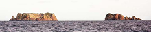
Curtis Island (left) and Cheeseman Island from north.
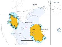
Map
Geography
Coordinates 30°33′S 178°34′W / 30.55°S 178.567°W / -30.55; -178.567
Archipelago Kermadec Islands
Area 40 ha (99 acres)
Highest elevation 130 m (430 ft)
Country

Curtis Island is an island in the southwest Pacific (located at 30°33′S 178°34′W / 30.55°S 178.567°W / -30.55; -178.567). It is a volcanic island with an elevation of 130 m (427 ft) and an area of 40 ha (99 acres). Together with neighboring Cheeseman Island it belongs to the Kermadec Islands. Politically it is part of New Zealand. The Kermadec Islands lie halfway between North Island, New Zealand and Tonga at approximately the latitude of the Gold Coast, Queensland.

Lieutenant John Cliffe Watts, RN was the first European to visit the Macauley and Curtis Islands — which he named after two of his officers — on the Lady Penrhyn in the late 1780s. Count von Luckner, Commander of the German raider Seeadler during the First World War, stopped off at Curtis Island to replenish his stores from the castaway depot left there by the New Zealand Marine Department (for the use of shipwrecked crews) while attempting to make good his escape from New Zealand to South America.

The island is a breeding site for the Masked Booby.[1]

See also

References

  1. ^ Greene et al. (2004).

External links


Wikimedia Foundation. 2010.

Игры ⚽ Поможем написать реферат

Look at other dictionaries:

  • Curtis Island — may refer to: Curtis Island (Queensland), Australia Curtis Island National Park, Queensland Curtis Island (Tasmania), Australia Curtis Island, New Zealand, in the Kermadec Islands Curtis Island (Maine), in the United States Curtis Island Light,… …   Wikipedia

  • Curtis Island (Kermadec Islands) — Curtis Island is an island in the southwest Pacific (located at coord|30|33|S|178|34|W|). It is a volcanic island with an elevation of 130 m and an area of 0.6 km². Together with neighboring Cheeseman Island it belongs to the Kermadec Islands.… …   Wikipedia

  • New Zealand general election, 2008 — 2005 ← members 8 November 2008 (2008 11 08) …   Wikipedia

  • New Zealand local elections, 2004 — Triennial elections for all 74 cities, districts, twelve Regional Councils and all District Health Boards in New Zealand were held on October 9, 2004. Most councils were elected using the First Past the Post method, but ten, of which Wellington… …   Wikipedia

  • Culture of New Zealand — The Kiwi has become a New Zealand icon. The culture of New Zealand is largely inherited from British and European custom, interwoven with Maori and Polynesian tradition. An isolated Pacific Island nation, New Zealand was comparatively recently… …   Wikipedia

  • 1968 in New Zealand — Population* Estimated Population as of 31 December: 2,773,000 http://www.stats.govt.nz/NR/rdonlyres/24107FC8 E7B5 4CF2 B17C 15E31CCA7D05/0/HistoricalPop.xls] * Increase since 31/12/1967: 28,000 (1.02%) * Males per 100 Females: 99.8 Note that this …   Wikipedia

  • 1940 in New Zealand — Population* Estimated Population as of 31 December: 1,633,600 http://www.stats.govt.nz/NR/rdonlyres/24107FC8 E7B5 4CF2 B17C 15E31CCA7D05/0/HistoricalPop.xls] * Increase since 31/12/1939: 8000 ( 0.49%) * Males per 100 Females: 99.1IncumbentsRegal… …   Wikipedia

  • List of islands of New Zealand — New Zealand consists of a large number of islands. The two main islands, which are much larger than the rest and where most of the population lives, are the North Island and the South Island. The latter is often a little ironically referred to as …   Wikipedia

  • Nelson (New Zealand electorate) — Area covered by the Nelson electorate since 1996 Nelson is a New Zealand Parliamentary electorate, returning one Member of Parliament to the New Zealand House of Representatives. From 1853 to 1860, the electorate was called Town of Nelson. From… …   Wikipedia

  • Motueka (New Zealand electorate) — Motueka is a former New Zealand Parliamentary electorate. The electorate of Motueka and Massacre Bay, created for the New Zealand general election, 1853, was succeeded by the electorate of Motueka in the 1860 1861 election, and lasted until 1890 …   Wikipedia

Share the article and excerpts

Direct link
Do a right-click on the link above
and select “Copy Link”