- Cumbernauld House
-
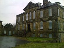 Cumbernauld House, entrance front
Cumbernauld House is an 18th-century country house located in Cumbernauld, Scotland. It is located near in the Cumbernauld Glen, close to Cumbernauld Village, at grid reference NS772759. The house is situated on the site of Cumbernauld Castle, which was besieged by General Monck in 1651. It was built in 1731,[1] to designs by William Adam (1689–1748), for John Fleming, 6th Earl of Wigtown. In the later 20th century the house was used as offices, first by Cumbernauld Development Corporation, then North Lanarkshire Council, and latterly by DH Morris, who went into liquidation in March 2007. Since then the building has lain dormant. Cumbernauld House is a category A listed building,[2] and is included on the Buildings at Risk Register.[3]
Contents
History
Cumbernauld Castle was built by the Fleming family, on the site where the house now sits. The castle played host to the royalty of Scotland, including Mary, Queen of Scots, who visited the castle and planted a yew tree at Castlecary Castle, only a mile or two away, which still grows there. The whole great hall collapsed while the queen was staying there on 26 January 1562, and 7 or 8 men were killed. Most of the queen's party were out hunting.[4] Mary was not hurt and visited the relatives of those who were injured or killed in the village below.[citation needed] After the new house was built, the castle was converted to stables, and was burnt down by dragoons posted here in 1746.[1] One original wall can still be seen in the allotment area.
 Cumbernauld House, garden front
William Adam was the foremost architect in Scotland during the first half of the 18th century, and Cumbernauld House is a particularly good example of his work.[citation needed]
In 1746 the retreating Jacobite army was billeted for a night in Cumbernauld village. Rather than stay in Cumbernauld House, the commander, Lord George Murray, slept in the village's Black Bull Inn, where he could enforce closer discipline on his soldiers.
The last Lord Fleming, Charles, 7th Earl of Wigtown, died childless in 1747, and the estates passed to the Elphinstone family. Naval officer and politician Charles Elphinstone-Fleming was laird from 1799-1840. Elphinstone-Fleming retired as an Admiral, and was MP for Stirlingshire. His son Lieutenant-Colonel John Elphinstone-Fleming became Lord Elphinstone in 1860, but died unmarried in 1861. The Cumbernauld property was then inherited by his nephew from Canterbury, Cornwallis Maude-Fleming, son of Lord Hawarden. Cornwallis was killed in action fighting the Boers as a Captain of the Grenadier Guards at Majuba Hill, Transvaal, in 1881. Before that, around 1870, the house was gutted and internally reconstructed.[2] In 1875, Maude-Fleming sold the Cumbernauld 'interesting historical estate' to John William Burns, son of James Burns of Bloomfield, for £160,000.[5] The Burns family sold the estate to the government for the development of Cumbernauld new town in 1955.
Following transfer of ownership to Cumbernauld Development Corporation, the first caretaker of Cumbernauld House was Stewart Law. Stewart Law was a Justice of the Peace, a correspondent for The Falkirk Herald, was on the Planning Committee for Cumbernauld New Town, and worked in the Architect's Office within Cumbernauld House. Stewart resided in Cumbernauld House with his wife, Helen Grant McGuire (b.01/06/1899 - d.12/02/1957), until his death in Glasgow Royal Infirmary on November 4, 1958 as a result of injuries sustained in a road traffic accident which had occurred in Cumbernauld Village four days earlier. He was 63 years old and left behind four sons, two daughters and twelve grandchildren.
Modern history
In January 2009 the Cumbernauld News reported that the Friends of Cumbernauld House had presented a case to the Scottish Government for the house to become a national museum of photography. One of the former residents of Cumbernauld House is reported to have been Lady Clementina Elphinstone-Fleming, a pioneer Victorian photographer. The articles goes on to note that the Scottish Government has stated there are no plans to buy the property.
In early 2010 a re-invigorated Facebook campaign was launched entitled 'Save and Preserve Cumbernauld House'.
Conservation area
Cumbernauld House is part of a historical conservation area running from the listed kirk and manse at Baronhill, through the Village conservation area with its Lang Riggs, to the site of Cumbernauld Castle and beyond that to the Comyn Motte and adjacent lime kilns. The whole represents the classic 'herringbone' layout of the mediaeval Scottish burgh with its principal street running from the castle to the church, along the summit of a ridge, with long narrow gardens (the Lang Riggs) stretching out behind. Cumbernauld village boasts almost the sole survivors of the land riggs feature in Scotland. From the slopes of the Wilderness Brae a panoramic view of the whole arrangement may be obtained - a view unique in Scotland: Edinburgh's Royal Mile in miniature. The wide centre of Main Street accommodated the stalls of the weekly market.
References
- ^ a b "Cumbernauld House, Site Number NS77NE 16.00". CANMORE. Royal Commission on the Ancient and Historical Monuments of Scotland. http://canmore.rcahms.gov.uk/en/site/45819/details/cumbernauld+house/. Retrieved 2010-02-02.
- ^ a b "Cumbernauld House, Listed Building Report". Historic Scotland. http://hsewsf.sedsh.gov.uk/hslive/hsstart?P_HBNUM=24086. Retrieved 2010-02-02.
- ^ "Cumbernauld House". Buildings at Risk Register for Scotland. Scottish Civic Trust. http://www.buildingsatrisk.org.uk/BAR/detail.aspx?sctID=3213. Retrieved 2010-02-02.
- ^ Calendar State Papers Scotland, vol. (1898), no. 1071, p. 598.
- ^ The Book of Dunbartonshire; Irving, 1878
- History of the Area, Cumbernauld Allotments Association
- Cumbernauld, Monklands Online
- "Days Gone By", Friends of Cumbernauld Glen
External links
- Cumbernauld House, sale particulars and background from King Sturge estate agents
- Cumbernauld House Park
- Photographs of the interior of the house
Categories:- Cumbernauld
- Houses in Scotland
- Buildings and structures in North Lanarkshire
- William Adam buildings
- Category A listed buildings in Scotland
- Listed buildings in North Lanarkshire
- Houses completed in 1731
- Country houses in Scotland


Wikimedia Foundation. 2010.