Townsend County

Townsend County
Townsend
New South Wales
Townsend NSW.PNG
Location in New South Wales
Lands administrative divisions around Townsend
Waradgery Waradgery Boyd
Wakool Townsend Urana
Cadell Moira (Vic) Denison

Townsend County is one of the 141 Cadastral divisions of New South Wales. It is in the south of New South Wales with the Murray River to the south. Deniliquin is located there.

Townsend County was named in honour of the surveyor Thomas S Townsend who was an assistant surveyor to Thomas Livingstone Mitchell.[1]

Parishes within this county

A full list of parishes found within this county; their current LGA and mapping coordinates to the approximate centre of each location is as follows:

Banangalite Conargo Shire Council 35°19′54″S 144°38′04″E / 35.33167°S 144.63444°E / -35.33167; 144.63444 (Banangalite)
Barratta Conargo Shire Council 35°13′54″S 144°33′04″E / 35.23167°S 144.55111°E / -35.23167; 144.55111 (Barratta)
Belmore Conargo Shire Council 35°13′54″S 145°00′04″E / 35.23167°S 145.00111°E / -35.23167; 145.00111 (Belmore)
Billabong Conargo Shire Council 35°06′54″S 144°35′04″E / 35.115°S 144.58444°E / -35.115; 144.58444 (Billabong)
Bingellibunbi Conargo Shire Council 35°01′54″S 144°43′04″E / 35.03167°S 144.71778°E / -35.03167; 144.71778 (Bingellibunbi)
Birganbigil Conargo Shire Council 35°30′54″S 145°11′04″E / 35.515°S 145.18444°E / -35.515; 145.18444 (Birganbigil)
Blackwood Conargo Shire Council 35°31′54″S 145°23′04″E / 35.53167°S 145.38444°E / -35.53167; 145.38444 (Blackwood)
Booabula Conargo Shire Council 35°08′54″S 145°00′04″E / 35.14833°S 145.00111°E / -35.14833; 145.00111 (Booabula)
Boonoke Conargo Shire Council 35°19′54″S 145°03′04″E / 35.33167°S 145.05111°E / -35.33167; 145.05111 (Boonoke)
Boorga Murray Shire Council 35°41′54″S 145°10′04″E / 35.69833°S 145.16778°E / -35.69833; 145.16778 (Boorga)
Booroorban Conargo Shire Council 35°00′54″S 144°45′04″E / 35.015°S 144.75111°E / -35.015; 144.75111 (Booroorban)
Boree Conargo Shire Council 35°17′54″S 144°48′04″E / 35.29833°S 144.80111°E / -35.29833; 144.80111 (Boree)
Bowna Conargo Shire Council 34°51′54″S 145°26′04″E / 34.865°S 145.43444°E / -34.865; 145.43444 (Bowna)
Boyeo Murray Shire Council 35°44′54″S 144°53′04″E / 35.74833°S 144.88444°E / -35.74833; 144.88444 (Boyeo)
Brassi Murray Shire Council 35°30′54″S 144°46′04″E / 35.515°S 144.76778°E / -35.515; 144.76778 (Brassi)
Bullatella Murray Shire Council 35°44′54″S 145°00′04″E / 35.74833°S 145.00111°E / -35.74833; 145.00111 (Bullatella)
Bungooka Murray Shire Council 35°44′54″S 145°09′04″E / 35.74833°S 145.15111°E / -35.74833; 145.15111 (Bungooka)
Campbell Conargo Shire Council 35°04′54″S 145°11′04″E / 35.08167°S 145.18444°E / -35.08167; 145.18444 (Campbell)
Carroonboon North Conargo Shire Council 35°00′54″S 144°37′04″E / 35.015°S 144.61778°E / -35.015; 144.61778 (Carroonboon North)
Carroonboon Conargo Shire Council 35°01′54″S 144°37′04″E / 35.03167°S 144.61778°E / -35.03167; 144.61778 (Carroonboon)
Carse Conargo Shire Council 34°54′54″S 145°27′04″E / 34.915°S 145.45111°E / -34.915; 145.45111 (Carse)
Citgathen Murray Shire Council 35°35′54″S 144°49′04″E / 35.59833°S 144.81778°E / -35.59833; 144.81778 (Citgathen)
Colimo Murray Shire Council 35°28′54″S 144°36′04″E / 35.48167°S 144.60111°E / -35.48167; 144.60111 (Colimo)
Conargo Conargo Shire Council 35°19′54″S 145°07′04″E / 35.33167°S 145.11778°E / -35.33167; 145.11778 (Conargo)
Coolagali Conargo Shire Council 35°34′54″S 145°05′04″E / 35.58167°S 145.08444°E / -35.58167; 145.08444 (Coolagali)
Coolambil Conargo Shire Council 35°08′54″S 145°04′04″E / 35.14833°S 145.06778°E / -35.14833; 145.06778 (Coolambil)
Cornalla Murray Shire Council 35°47′54″S 145°03′04″E / 35.79833°S 145.05111°E / -35.79833; 145.05111 (Cornalla)
Cudoc Murray Shire Council 35°41′54″S 144°47′04″E / 35.69833°S 144.78444°E / -35.69833; 144.78444 (Cudoc)
Currabunganung Conargo Shire Council 35°23′54″S 145°27′04″E / 35.39833°S 145.45111°E / -35.39833; 145.45111 (Currabunganung)
Dahwilly Conargo Shire Council 35°25′54″S 144°52′04″E / 35.43167°S 144.86778°E / -35.43167; 144.86778 (Dahwilly)
Derrulaman Murray Shire Council 35°37′54″S 145°00′04″E / 35.63167°S 145.00111°E / -35.63167; 145.00111 (Derrulaman)
Devon Conargo Shire Council 35°14′54″S 144°42′04″E / 35.24833°S 144.70111°E / -35.24833; 144.70111 (Devon)
Drysdale Conargo Shire Council 34°51′54″S 144°44′04″E / 34.865°S 144.73444°E / -34.865; 144.73444 (Drysdale)
Dulverton Conargo Shire Council 35°13′54″S 144°49′04″E / 35.23167°S 144.81778°E / -35.23167; 144.81778 (Dulverton)
Dunkeld Conargo Shire Council 35°01′54″S 145°20′04″E / 35.03167°S 145.33444°E / -35.03167; 145.33444 (Dunkeld)
Edgar Conargo Shire Council 35°01′54″S 145°16′04″E / 35.03167°S 145.26778°E / -35.03167; 145.26778 (Edgar)
Euroka Conargo Shire Council 35°07′54″S 145°22′04″E / 35.13167°S 145.36778°E / -35.13167; 145.36778 (Euroka)
Euroley Conargo Shire Council 34°52′54″S 145°00′04″E / 34.88167°S 145.00111°E / -34.88167; 145.00111 (Euroley)
Finlay Conargo Shire Council 35°03′54″S 145°05′04″E / 35.065°S 145.08444°E / -35.065; 145.08444 (Finlay)
Gilbert Conargo Shire Council 35°02′54″S 145°00′04″E / 35.04833°S 145.00111°E / -35.04833; 145.00111 (Gilbert)
Gobram Murray Shire Council 35°31′54″S 144°34′04″E / 35.53167°S 144.56778°E / -35.53167; 144.56778 (Gobram)
Gonawarra Conargo Shire Council 35°05′54″S 144°54′04″E / 35.09833°S 144.90111°E / -35.09833; 144.90111 (Gonawarra)
Gotha Murray Shire Council 35°35′54″S 144°39′04″E / 35.59833°S 144.65111°E / -35.59833; 144.65111 (Gotha)
Harold Conargo Shire Council 34°56′54″S 145°06′04″E / 34.94833°S 145.10111°E / -34.94833; 145.10111 (Harold)
Hartwood Conargo Shire Council 35°18′54″S 145°28′04″E / 35.315°S 145.46778°E / -35.315; 145.46778 (Hartwood)
Hebden Conargo Shire Council 35°08′54″S 144°01′04″E / 35.14833°S 144.01778°E / -35.14833; 144.01778 (Hebden)
Jung Jung Conargo Shire Council 34°59′54″S 145°26′04″E / 34.99833°S 145.43444°E / -34.99833; 145.43444 (Jung Jung)
Kerranakoon Conargo Shire Council 35°24′54″S 144°46′04″E / 35.415°S 144.76778°E / -35.415; 144.76778 (Kerranakoon)
Lamb Conargo Shire Council 35°05′54″S 145°00′04″E / 35.09833°S 145.00111°E / -35.09833; 145.00111 (Lamb)
Loch Conargo Shire Council 34°51′54″S 145°22′04″E / 34.865°S 145.36778°E / -34.865; 145.36778 (Loch)
Mallee Conargo Shire Council 35°12′54″S 144°56′04″E / 35.215°S 144.93444°E / -35.215; 144.93444 (Mallee)
Monimail Conargo Shire Council 35°20′54″S 144°55′04″E / 35.34833°S 144.91778°E / -35.34833; 144.91778 (Monimail)
Moonbria Conargo Shire Council 35°12′54″S 145°21′04″E / 35.215°S 145.35111°E / -35.215; 145.35111 (Moonbria)
Morago Conargo Shire Council 35°20′54″S 144°38′04″E / 35.34833°S 144.63444°E / -35.34833; 144.63444 (Morago)
Morton Conargo Shire Council 34°53′54″S 145°32′04″E / 34.89833°S 145.53444°E / -34.89833; 145.53444 (Morton)
Moultrassie Conargo Shire Council 34°56′54″S 145°21′04″E / 34.94833°S 145.35111°E / -34.94833; 145.35111 (Moultrassie)
Mundiwa Conargo Shire Council 35°31′04″S 145°05′34″E / 35.51778°S 145.09278°E / -35.51778; 145.09278 (Mundiwa)
Myall Conargo Shire Council 34°54′54″S 144°37′04″E / 34.915°S 144.61778°E / -34.915; 144.61778 (Myall)
Nallam Murray Shire Council 35°48′54″S 144°57′04″E / 35.815°S 144.95111°E / -35.815; 144.95111 (Nallam)
Nardoo Conargo Shire Council 35°05′54″S 145°30′04″E / 35.09833°S 145.50111°E / -35.09833; 145.50111 (Nardoo)
Narrama Conargo Shire Council 35°31′54″S 145°17′04″E / 35.53167°S 145.28444°E / -35.53167; 145.28444 (Narrama)
Narratoola Murray Shire Council 35°44′54″S 145°18′04″E / 35.74833°S 145.30111°E / -35.74833; 145.30111 (Narratoola)
Neerim Conargo Shire Council 35°09′54″S 145°09′04″E / 35.165°S 145.15111°E / -35.165; 145.15111 (Neerim)
North Conargo Conargo Shire Council 35°14′54″S 145°08′04″E / 35.24833°S 145.13444°E / -35.24833; 145.13444 (North Conargo)
North Currabunganung Conargo Shire Council 35°18′54″S 145°21′04″E / 35.315°S 145.35111°E / -35.315; 145.35111 (North Currabunganung)
North Deniliquin Conargo Shire Council 35°31′54″S 145°00′04″E / 35.53167°S 145.00111°E / -35.53167; 145.00111 (North Deniliquin)
North Moonbria Conargo Shire Council 35°02′54″S 145°25′04″E / 35.04833°S 145.41778°E / -35.04833; 145.41778 (North Moonbria)
North Zara Conargo Shire Council 35°05′54″S 144°45′04″E / 35.09833°S 144.75111°E / -35.09833; 144.75111 (North Zara)
Nyangay Conargo Shire Council 34°53′54″S 144°49′04″E / 34.89833°S 144.81778°E / -34.89833; 144.81778 (Nyangay)
Officer Conargo Shire Council 35°04′54″S 144°42′04″E / 35.08167°S 144.70111°E / -35.08167; 144.70111 (Officer)
Palmer Conargo Shire Council 34°52′54″S 144°54′04″E / 34.88167°S 144.90111°E / -34.88167; 144.90111 (Palmer)
Peppin Conargo Shire Council 35°13′54″S 144°53′04″E / 35.23167°S 144.88444°E / -35.23167; 144.88444 (Peppin)
Powheep Conargo Shire Council 34°54′54″S 145°16′04″E / 34.915°S 145.26778°E / -34.915; 145.26778 (Powheep)
Puckawidgee Conargo Shire Council 35°12′54″S 145°14′04″E / 35.215°S 145.23444°E / -35.215; 145.23444 (Puckawidgee)
Pungulgui Conargo Shire Council 35°39′54″S 145°19′04″E / 35.665°S 145.31778°E / -35.665; 145.31778 (Pungulgui)
Purdanima Murray Shire Council 35°31′54″S 144°41′04″E / 35.53167°S 144.68444°E / -35.53167; 144.68444 (Purdanima)
Quandong Conargo Shire Council 34°51′54″S 144°39′04″E / 34.865°S 144.65111°E / -34.865; 144.65111 (Quandong)
Quiamong Conargo Shire Council 35°21′54″S 145°14′04″E / 35.365°S 145.23444°E / -35.365; 145.23444 (Quiamong)
Ricketson Conargo Shire Council 35°13′54″S 144°39′04″E / 35.23167°S 144.65111°E / -35.23167; 144.65111 (Ricketson)
Ronald Conargo Shire Council 34°56′54″S 144°49′04″E / 34.94833°S 144.81778°E / -34.94833; 144.81778 (Ronald)
South Deniliquin Deniliquin Council 35°34′54″S 144°56′04″E / 35.58167°S 144.93444°E / -35.58167; 144.93444 (South Deniliquin)
South Zara Conargo Shire Council 35°11′54″S 144°44′04″E / 35.19833°S 144.73444°E / -35.19833; 144.73444 (South Zara)
Stanaforth Conargo Shire Council 35°11′54″S 144°33′04″E / 35.19833°S 144.55111°E / -35.19833; 144.55111 (Stanaforth)
Tawarra Murray Shire Council 35°43′54″S 145°14′04″E / 35.73167°S 145.23444°E / -35.73167; 145.23444 (Tawarra)
Tholobin Conargo Shire Council 35°24′54″S 145°06′04″E / 35.415°S 145.10111°E / -35.415; 145.10111 (Tholobin)
Thulabin Conargo Shire Council 35°23′54″S 145°18′04″E / 35.39833°S 145.30111°E / -35.39833; 145.30111 (Thulabin)
Thurgoon Conargo Shire Council 35°36′54″S 145°10′04″E / 35.615°S 145.16778°E / -35.615; 145.16778 (Thurgoon)
Towool Murray Shire Council 35°41′54″S 145°03′04″E / 35.69833°S 145.05111°E / -35.69833; 145.05111 (Towool)
Tumudgery Murray Shire Council 35°25′54″S 144°41′04″E / 35.43167°S 144.68444°E / -35.43167; 144.68444 (Tumudgery)
Walla Conargo Shire Council 34°59′54″S 145°33′04″E / 34.99833°S 145.55111°E / -34.99833; 145.55111 (Walla)
Wandook Deniliquin Council 35°26′54″S 145°02′04″E / 35.44833°S 145.03444°E / -35.44833; 145.03444 (Wandook)
Wanganella Conargo Shire Council 35°09′54″S 144°50′04″E / 35.165°S 144.83444°E / -35.165; 144.83444 (Wanganella)
Warbreccan Murray Shire Council 35°30′54″S 144°51′04″E / 35.515°S 144.85111°E / -35.515; 144.85111 (Warbreccan)
Wargam Conargo Shire Council 35°00′54″S 144°55′04″E / 35.015°S 144.91778°E / -35.015; 144.91778 (Wargam)
Warrawool Conargo Shire Council 35°37′54″S 145°15′04″E / 35.63167°S 145.25111°E / -35.63167; 145.25111 (Warrawool)
Warriston Conargo Shire Council 35°08′54″S 145°15′04″E / 35.14833°S 145.25111°E / -35.14833; 145.25111 (Warriston)
Warwillah Conargo Shire Council 35°01′54″S 144°54′04″E / 35.03167°S 144.90111°E / -35.03167; 144.90111 (Warwillah)
Werai Murray Shire Council 35°20′54″S 144°32′04″E / 35.34833°S 144.53444°E / -35.34833; 144.53444 (Werai)
Werkenbergal Conargo Shire Council 34°59′54″S 145°00′04″E / 34.99833°S 145.00111°E / -34.99833; 145.00111 (Werkenbergal)
Willeroo Conargo Shire Council 35°27′54″S 145°11′04″E / 35.465°S 145.18444°E / -35.465; 145.18444 (Willeroo)
Willurah Conargo Shire Council 34°59′54″S 145°07′04″E / 34.99833°S 145.11778°E / -34.99833; 145.11778 (Willurah)
Winter Conargo Shire Council 35°01′54″S 144°48′04″E / 35.03167°S 144.80111°E / -35.03167; 144.80111 (Winter)
Wollamai Conargo Shire Council 35°31′54″S 145°27′04″E / 35.53167°S 145.45111°E / -35.53167; 145.45111 (Wollamai)
Wonnue Berrigan Shire Council 35°44′54″S 145°23′04″E / 35.74833°S 145.38444°E / -35.74833; 145.38444 (Wonnue)
Wononga Conargo Shire Council 35°13′54″S 145°28′04″E / 35.23167°S 145.46778°E / -35.23167; 145.46778 (Wononga)
Woonox Conargo Shire Council 35°26′54″S 144°57′04″E / 35.44833°S 144.95111°E / -35.44833; 144.95111 (Woonox)
Wureep Conargo Shire Council 34°52′54″S 145°07′04″E / 34.88167°S 145.11778°E / -34.88167; 145.11778 (Wureep)
Yalama Murray Shire Council 35°39′54″S 144°53′04″E / 35.665°S 144.88444°E / -35.665; 144.88444 (Yalama)
Yalgadoori Conargo Shire Council 35°39′54″S 145°24′04″E / 35.665°S 145.40111°E / -35.665; 145.40111 (Yalgadoori)
Yallakool Murray Shire Council 35°29′54″S 144°30′04″E / 35.49833°S 144.50111°E / -35.49833; 144.50111 (Yallakool)
Yaloke Murray Shire Council 35°37′54″S 144°44′04″E / 35.63167°S 144.73444°E / -35.63167; 144.73444 (Yaloke)

References

  1. ^ Geographical Names Board of NSW

Wikimedia Foundation. 2010.

Игры ⚽ Нужно сделать НИР?

Look at other dictionaries:

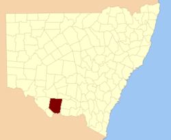
  • Townsend County, New South Wales — Infobox Australian cadastral name = Townsend state = New South Wales caption = Location in New South Wales near nw = Waradgery near n = Waradgery near ne = Boyd near e = Urana near se = Denison near s = Moira (Vic) near sw = Cadell near w =… …   Wikipedia

  • Townsend — is a surname of Yorkshire and Norfolk origin. In English its meaning is a topographic name indicating residence at the extremity of a city or burgh (from Middle English touun ‘village’, ‘hamlet’, ‘stead’ + ende ‘end’.) The name is first… …   Wikipedia

  • Townsend House — bezeichnet mehrere gleichnamige, im NRHP gelistete, Objekte: Townsend House (Illinois), ID Nr. 05000111 Townsend House (Louisiana), ID Nr. 82002779 Townsend House (Barnstable County, Massachusetts), ID Nr. 98000542 Townsend House (Norfolk County …   Deutsch Wikipedia

  • County Line, Wisconsin —   Unincorporated community   …   Wikipedia

  • Townsend Township, Ohio — may refer to:*Townsend Township, Huron County, Ohio *Townsend Township, Sandusky County, Ohio …   Wikipedia

  • Townsend Township — ist der Name mehrerer Townships in den Vereinigten Staaten: Townsend Township (Huron County, Ohio) Townsend Township (Sandusky County, Ohio) Diese Seite ist eine Begriffsklärung zur Unterscheidung mehrerer mit demselben Wort bezeichne …   Deutsch Wikipedia

  • Townsend, Georgia — Townsend is an unincorporated community in McIntosh County, Georgia, United States. It lies along State Route 57 northwest of the city of Darien, the county seat of McIntosh County. [Rand McNally. The Road Atlas 06. Chicago: Rand McNally, 2006, p …   Wikipedia

  • Townsend, Ontario — Townsend is a planned community in Haldimand County, Ontario, Canada that was founded in 1970. While there used to be some commercial activity (variety store, hairdressing salon, and other numerous small businesses), the community now consists of …   Wikipedia

  • Townsend Scudder — (July 26, 1865 February 22, 1960) was a United States Representative from New York. Born in Northport, he was a nephew of Henry Joel Scudder, also a U.S. Representative from New York. Townsend attended preparatory schools in Europe and was… …   Wikipedia

  • Townsend, Virginia — Townsend is an unincorporated community in Northampton County, Virginia, United States.Reference* [http://geonames.usgs.gov/pls/gnispublic/f?p=gnispq:3:::NO::P3 FID:http://geonames.usgs.gov/pls/gnispublic/f?p=150:3:14196352714509222546::NO::P3… …   Wikipedia

Share the article and excerpts

Direct link
Do a right-click on the link above
and select “Copy Link”