- Denison County
-
Denison
New South Wales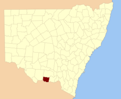
Location in New South WalesLands administrative divisions around Denison Townsend Urana Urana Townsend Denison Hume Moira (Vic) Moira (Vic) Bogong (Vic) Denison County is one of the 141 Cadastral divisions of New South Wales. It contains the towns of Barooga and Berrigan.
Denison County was named in honour of the Governor-General of New South Wales, Sir William Thomas Denison (1804-1871).[1]
Parishes within this county
A full list of parishes found within this county; their current LGA and mapping coordinates to the approximate centre of each location is as follows:
References
Categories:- Counties of New South Wales

Wikimedia Foundation. 2010.