- New York State Route 338 (1940s–1980)
-
NYS Route 338
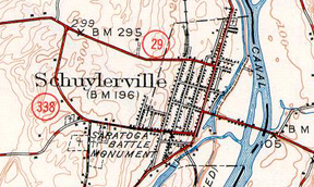
1949 quadrangle of Schuylerville marking the entire length of NY 338.Route information Maintained by NYSDOT Length: 1.35 mi[4] (2.17 km) Existed: 1940s[1][2] – April 1, 1980[3] Major junctions West end:  NY 29 in Northumberland
East end: 
 US 4 / NY 32 in Schuylerville
Location Counties: Saratoga Highway system Numbered highways in New York
Interstate • U.S. • N.Y. (former) • Reference • County←  NY 337
NY 338  →
→New York State Route 338 (NY 338) was a state highway in Saratoga County, New York, United States. It served as a bypass of the village of Schuylerville, linking NY 29 west of the village to U.S. Route 4 and NY 32 in the southern portion of Schuylerville. West of the village limits, NY 338 was known as Monument Road; within Schuylerville, it was named Burgoyne Street. NY 338 was assigned in the 1940s and removed in 1980, at which time the NY 338 designation was reassigned to another roadway in Washington County. The former routing of NY 338 outside of the Schuylerville village limits is now County Route 338.
Contents
Route description
NY 338 began at an intersection with NY 29 in Northumberland, west of the Schuylerville village limits. The highway headed to the southeast as Monument Road, passing over small hills as it encircled the western extents of Schuylerville. At the Cemetery of the Visitation BMV, site of the Saratoga Monument, NY 338 merged with Burgoyne Road and became Burgoyne Street. Past this point, NY 338 continued east into southern Schuylerville, where it terminated at an intersection with U.S. Route 4 and NY 32.[5]
History
NY 338 was assigned in the 1940s to a southeastern bypass of Schuylerville extending from NY 29 to U.S. Route 4 and NY 32.[1][2] The route was not maintained by the state of New York, however: it was maintained by Saratoga County (from NY 29 to the Schuylerville village line) and by the village of Schuylerville (the portion within Schuylerville). On April 1, 1980, the NY 338 designation was removed and reassigned to another roadway in Washington County that had been transferred from the county to the state.[3][6] The portion of former NY 338 from NY 29 to the Schuylerville village line is now County Route 338.[5]
Major intersections
The entire route was in Saratoga County.
Location Mile[4] Destinations Notes Northumberland 0.00 NY 29Schuylerville 1.35 US 4 / NY 321.000 mi = 1.609 km; 1.000 km = 0.621 mi References
- ^ a b Shell Oil Company (1940). Map of New York (Map). Cartography by H.M. Gousha Company.
- ^ a b United States Geological Survey (1949). New York – Schuylerville Quadrangle (Map). 1:62,500. 15-Minute Series. http://docs.unh.edu/NY/schy49ne.jpg. Retrieved March 26, 2009.
- ^ a b New York State Legislature. "Highway Law, Article 12, Section 341". http://public.leginfo.state.ny.us/menugetf.cgi?COMMONQUERY=LAWS. Retrieved March 26, 2009. The Schuylerville alignment of NY 338 is not listed in the highway law and was never transferred from the state to the county, thus the Schuylerville highway was never state-maintained.
- ^ a b New York State Department of Transportation (March 2, 2009). "Region 1 Inventory Listing". https://www.nysdot.gov/divisions/engineering/technical-services/highway-data-services/inventory-listing. Retrieved March 26, 2009.
- ^ a b Google, Inc. Google Maps – overview map of former NY 338 (Map). Cartography by Google, Inc. http://maps.google.com/maps?sourceid=navclient&ie=UTF-8&rlz=1T4ADBF_enUS232US232&q=from%3A%20Burgoyne%20St%2FCR-338%20%4043.097800%2C%20-73.582170%20to%3A%20CR-338%20%4043.107670%2C%20-73.598338&um=1&sa=N&tab=wl. Retrieved April 29, 2008.
- ^ Rand McNally (1985). New York (Map). ISBN 0-528-91040-X.
External links
Categories:- Former state highways in New York
- Transportation in Saratoga County, New York


Wikimedia Foundation. 2010.