- 2009 California wildfires
-
2009 California Wildfires 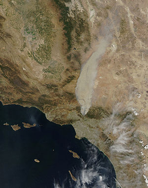
Detail from MODIS satellite image of Station Fire, August 29, 2009.Location California Date July 7, 2009 - October 27, 2009 Burned area More than 336,020 acres (525 sq mi; 1,360 km2) Fatalities 2 The 2009 California wildfires were a series of 63 wildfires that were active in the state of California, USA, during the year 2009.[1] The fires burned more than 336,020 acres (525 sq mi; 1,360 km2) of land from the beginning of July through late November due to red flag warnings, destroying hundreds of structures and killing two people.[2] Although the fires burned many different regions of California in August, the month was especially notable for several very large fires which burned in Southern California, despite being outside of the normal fire season for that region.
The Station Fire, north of Los Angeles, was the largest and deadliest of these wildfires, burning 160,577 acres (251 sq mi; 650 km2) and killing two firefighters since it began in late August. Another large fire was the La Brea Fire, which burned nearly 90,000 acres (141 sq mi; 364 km2) in Santa Barbara County earlier in the month. A state of emergency was also declared for the 7,800 acres (12 sq mi; 32 km2) Lockheed Fire in Santa Cruz County to the north.
Contents
Conditions
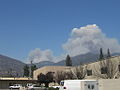
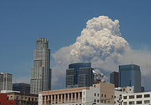 Pyrocumulus cloud from the Station Fire towers over the skyline of downtown Los Angeles, California.
Invasive, non-native vegetation dies and re-sprouts year after year creating an unnatural buildup of dead plant material.[3] While periodic fires are natural, and many native plants depend upon fire to reproduce,[4] the intensity and frequency of these fires is altered by the presence of non-natives.[3]
In Southern California, the normal wildfire season begins in October with the arrival of the infamous Santa Ana winds, and it is unusual to see fires spread so rapidly at other times of year. However, temperatures throughout the southern part of the state exceeded 100 °F (38 °C) for much of late August. The combination of high temperatures, low humidity and a large quantity of tinder-dry fuel, some of which had not burnt for decades, allowed some of the normal fires to quickly explode out of control despite the lack of winds to spread the flames. These conditions, along with extreme terrain in many undeveloped areas that slowed access to burn areas, made firefighting difficult.
Notable fires
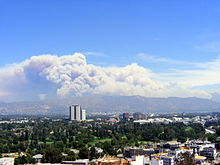 Picture of Los Angeles fires in August 2009. Photo was taken from Universal Studios Hollywood.
Dozens of fires burned throughout California in August 2009. Some of the most notable are listed here.
Northern California
Alameda County
- The Corral Fire began on August 13 along Corral Hollow Road, outside the Carnegie State Vehicular Recreation Area, near Tracy in Alameda County. It burned 12,500 acres (20 sq mi; 51 km2) of dry grass before being fully contained on August 16.[5][6]
Mariposa County
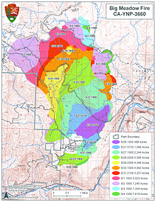 Progression of the Big Meadow Fire between August 26 and September 5, 2009. Map courtesy of the United States Forest Service.
- The Big Meadow Fire began on August 26 in Big Meadow, two miles (3 km) east of El Portal, just inside Yosemite National Park. As of September 4, this fire has burned 7,425 acres (12 sq mi; 30 km2) in the Mariposa County section of Yosemite, resulting in the closure of several trails, campgrounds and the portion of State Highway 120 known as Tioga Road. The community of Foresta was evacuated but residents were allowed to return on September 4. The Big Meadow Fire is 96% contained as of September 6, with full containment expected by September 10.[7] This blaze was the result of a prescribed burn gone out of control, leading some to question the judgment of Park authorities.[8]
Placer County
- The Mammoth Fire started on July 16 and burned 643 acres (3 km2) in the American River Canyon and Mammoth Bar Recreation Area east of Auburn before it was contained on July 18.[9] The fire closed the Foresthill Bridge, the highest bridge in California, for 2 days. It took 358 firefighters, 24 engines, and a helicopter to put out. The cause was undetermined as of July 18, 2009.[9]
- The Foresthill Fire started on August 27 and burned 30 acres (120,000 m2) along the American River Canyon near the Foresthill Bridge before it was contained on August 28. This fire is close to the location of the Mammoth Fire.[10] The fire took over 100 firefighters, 10 engines, 3 airtankers (planes), and 2 helicopters to extinguish. The cause was undetermined as of August 28, 2009.[10]
- The 49 Fire was a small but very destructive fire that began on August 30 and was fully contained by CalFire on September 1. Although it burned only 343 acres (0.5 sq mi; 1.4 km2), it destroyed 63 homes and 3 commercial structures in the unincorporated area of North Auburn in Placer County. The fire extensively damaged 3 more homes and 6 more businesses.[11] The fire began along the east side of Highway 49, which led to the name 49 Fire. The fire quickly spread north and east.[12] The fire spread so quickly that some residents barely escaped their burning homes.[13] Auburn Municipal Airport was closed during the fire, which burned right up to the runway.[12] The fire's cause is arson.[citation needed] The arsonist lit a second fire just east of the original fire 20 minutes after the first fire.[citation needed] This added to the destruction and fire spread.[14][15] This was the second fire to burn the area in 5 years.[13]
Santa Cruz/Monterey/San Benito Counties
- The Lockheed Fire began on August 12 near the Lockheed Martin Space Systems campus in Santa Cruz County.[16][17] A total of 7,817 acres (12 sq mi; 32 km2) burned and thirteen structures were destroyed, including four seasonal cabins but no primary residences. No cause has been identified.[18] The communities of Swanton and Bonny Doon were evacuated and a state of emergency was declared by Lieutenant Governor John Garamendi on August 14.[19] State fire crews achieved 100% containment on August 23, at a cost of US$26.6 million.[18] Many hillsides burned by the Lockheed Fire had not burned since 1948 due to active fire suppression in the area. Some plant species endemic to the area, including the endangered Santa Cruz manzanita, propagate only after fire, potentially allowing these rare species to proliferate for the first time in decades.[20]
- The Bryson Fire started from a mobile home fire on Bryson-Hesperia Road in the Monterey County town of Lockwood. It burned 3,383 acres (5 sq mi; 14 km2) and five structures, including three homes, between August 26 and August 28.[21][22]
- The Gloria Fire began on August 27 along Camphora Gloria Road near the town of Soledad. It burned 6,437 acres (10 sq mi; 26 km2) in Monterey and San Benito counties, destroying a house and another structure before CalFire contained it on August 31 at a cost of US$4 million.[23] The fire was set off by fireworks used to scare away birds outside of a winery and a criminal investigation is underway to determine who is responsible.[24]
- The Loma Fire (October 25–27), 485 acres (0.758 sq mi; 1.96 km2) (initially reported as 600 acres) began near Loma Prieta Way in Santa Clara County and spread to the Santa Cruz County area of Maymens Flat - Highland Road, Eureka Canyon and Ormsby. One residence destroyed with 160 structures threatened and evacuations in place for north Ormsby Cutoff until October 26. 1,742 firefighters with 4 injuries reported; cost $2.7 million.[25] High winds contributed to the spread in the Summit area of the Santa Cruz Mountains in an area which had 6 inches (150 mm) of rain on October 13.[26][27]
Yuba County
- The Yuba Fire was started after a Red-Tailed Hawk flew into a power line on August 14, and burned 3,891 acres (6 sq mi; 16 km2) before being contained on August 21 at a cost of US$12.1 million. Two residences in Yuba County burned and power lines transporting electricity from a hydroelectric facility were threatened.[28][29]
Other counties
August fires also struck areas of Colusa, Lassen, Plumas, Santa Clara, Shasta, Siskiyou and Solano counties.
Southern California
Los Angeles County
- The Morris Fire (August 25 – September 3, 2,168 acres (3 sq mi; 9 km2)) began near Morris Dam in the Angeles National Forest.[30] This fire is thought to have been caused by arson.[31]
- The Station Fire (August 26 – October 16, 160,577 acres (251 sq mi; 650 km2), 209 structures destroyed, including 89 homes) [32] started in the Angeles National Forest near the U.S. Forest Service ranger station on the Angeles Crest Highway (State Highway 2).[33][34] Two firefighters were killed on August 30 while attempting to escape the flames when their fire truck plunged off a cliff.[35] The blaze threatened 12,000 structures in the National Forest and the nearby communities of La Cañada Flintridge, Glendale, Acton, La Crescenta, Littlerock and Altadena, as well as the Sunland and Tujunga neighborhoods of the City of Los Angeles.[36] Many of these areas faced mandatory evacuations as the flames drew near, but as of September 6, all evacuation orders were lifted.[37] The Station Fire burned on the slopes of Mount Wilson, threatening numerous television, radio and cellular telephone antennas on the summit, as well as the Mount Wilson Observatory, which includes several historically significant telescopes and multi-million-dollar astronomical facilities operated by UCLA, USC, UC Berkeley and Georgia State University.[38] A 40-mile (64-kilometer) stretch of the Angeles Crest Highway was closed indefinitely due to guardrail and sign damage, although the pavement remained largely intact.[39]
On September 3, officials announced that the Station Fire was caused by arson, and that a homicide investigation had been initiated. Investigators discovered a substance at the fire's point of origin which they believe may have accelerated the flames.[40] The Station Fire claimed the lives of two Los Angeles County firefighters who were killed when their vehicle left the roadway due to heavy smoke conditions, reducing visibility. The two firefighters, assigned to a fire inmate hand crew camp (jointly operated by the Los Angeles County Fire Department and California Department of Corrections [41]), had been searching for a safe escape zone to help evacuate the camp's inmate crews who were being forced to evacuate due to the Station Fire threatening the camp.[42] As of September 15, $93.8 million (US) had been spent fighting the fire at 91% contained with full containment by September 19.[43] It was 100% contained at 7:00 P.M. PST on Friday, October 16, 2009, due to moderate rainfall. Property owners and concerned citizens are demanding a formal Congressional investigation as to why the U.S. Forest Service did not contain the fire within the first 48 hours when it was manageable.[citation needed] At 160,557 acres (649.75 km2), the Station Fire is the 10th largest in modern California history,[34][44] and the largest wildfire in the modern history of Los Angeles County, passing the 105,000-acre (164 sq mi; 425 km2) Clampitt Fire of September 1970.[45]
-
The Station Fire burning as seen from Arcadia, California.
-
Progression of the Station Fire through September 4, 2009. Note the huge expansion on August 29. Map courtesy of the United States Forest Service.
-

Pyrocumulus cloud from the Station Fire, seen from North Hollywood, Los Angeles.
-
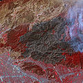
This near infra-red image shows the extent of the burned area from the Station Fire.
San Bernardino County
- The Sheep Fire (October 3–10, 7,128 acres (11.1 sq mi; 28.8 km2)) started near Sheep Canyon Road near Lytle Creek east of Mount Baldy and west of the Cajon Pass in the San Gabriel Mountains. Mandatory evacuations were in place for all Wrightwood residents October 4–6; the fireline held at 0.3-mile (480 m) from Wrightwood homes. Five structures had been destroyed in the Lone Pine and Swarthout Canyon areas including one residence. Eight firefighters have been injured but no fatalities have been reported.[46] Below-freezing temperatures in the mountain areas helped fire crews in containment on October 6.[47] Suppression costs as of 9 October 2009[update]: $7,977,000.[48]
Santa Barbara County
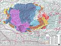
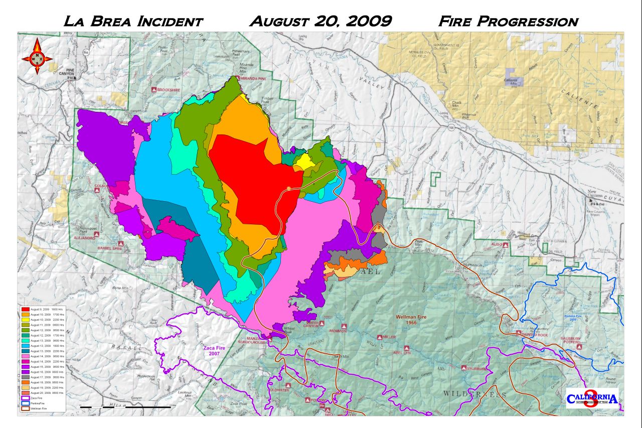
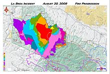 Progression of the La Brea Fire through August 20, along with outlines of the Zaca Fire (2007) and Wellman Fire (1966). Map courtesy of the United States Forest Service.
- The La Brea Fire began near La Brea Creek in Santa Barbara County, inside of Los Padres National Forest.[49] The fire burned 89,489 acres (140 sq mi; 362 km2) of chaparral between August 8 and August 22, but only destroyed two structures—a cabin and an unused ranger station.[50] The huge Zaca Fire burned in the same region in 2007, and some of the same fire lines were used to contain the La Brea Fire.[51] A propane stove at an illegal marijuana plantation inside the National Forest is believed to have ignited the fire. The plantation held approximately 30,000 marijuana plants, worth an estimated US$90 million. Prior to the blaze, seventeen other plantations hidden in the forest had been discovered by authorities, who destroyed more than 225,000 plants worth over US$675 million. No suspects were captured at the site, but investigators did find an AK-47 assault rifle, and warned the public that the suspects could be armed and dangerous.[52]
Ventura County
The Guiberson fire in Ventura County has burnt an estimated 8,500 acres (34 km2), destroying two outbuildings and injuring two firefighters. Governor Schwarzenegger declared a state of emergency. The fire, which started between Fillmore and Moorpark, has caused the evacuation of almost 600 homes in Meridian Hills and Bardsdale; about 1,000 structures are threatened, in addition to oil pipelines in the area. On September 27, the Guiberson Fire was 100 percent contained after burning approximately 17,500 acres (71 km2); the cause is still unconfirmed.[53]
Other counties
Smaller fires also broke out in Orange, Riverside, San Bernardino and San Diego counties in August.
See also
- 2010 California wildfires
- November 2008 California wildfires
- Summer 2008 California wildfires
- October 2007 California wildfires
- Old Fire (2003)
- Cedar Fire
References
- ^ Current Fire Information. California Department of Forestry and Fire Protection. Accessed October 29, 2009.
- ^ "Wildfire spreads along 241 toll road just east of Anaheim Hills [Updated"]. Los Angeles Times. November 24, 2009. http://latimesblogs.latimes.com/lanow/2009/11/wildfire-spreads-along-241-toll-road-just-east-of-anahiem-hills.html.
- ^ a b Zouhar, Kristin; Smith, Jane Kapler; Sutherland, Steve; Brooks, Matthew L. (2008). "Wildland fire in ecosystems: fire and nonnative invasive plants". [United States Forest Service]. http://www.fs.fed.us/rm/pubs/rmrs_gtr042_6.html. Retrieved February 17, 2011.
- ^ Jack Ainsworth & Troy Alan Doss (1995). "Natural History of Fire & Flood Cycles". California Coastal Commission. http://www.coastal.ca.gov/fire/ucsbfire.html. Retrieved 17 February 2011.
- ^ "Corral Fire". California Department of Forestry and Fire Protection. August 18, 2009. http://cdfdata.fire.ca.gov/incidents/incidents_details_info?incident_id=363. Retrieved September 3, 2009.
- ^ Salonga, Robert. (August 17, 2009). "Corral fire fully contained after burning 12,500 acres". Contra Costa Times. http://www.insidebayarea.com/livermore/ci_13143709. Retrieved September 3, 2009.
- ^ "Big Meadow Wildfire". InciWeb (United States Forest Service). September 4, 2009. http://inciweb.org/incident/1869/. Retrieved September 5, 2009.
- ^ "A Note From Yosemite's Superintendent". InciWeb (United States Forest Service). August 29, 2009. http://inciweb.org/incident/article/9328/. Retrieved September 3, 2009.
- ^ a b CalFIRE (July 18, 2009). "Mammoth Fire Fire Incident Information". Archived from the original on September 15, 2009. http://cdfdata.fire.ca.gov/incidents/incidents_details_info?incident_id=340. Retrieved September 12, 2009.
- ^ a b CalFIRE (August 28, 2009). "Foresthill Fire Fire Incident Information". http://cdfdata.fire.ca.gov/incidents/incidents_details_info?incident_id=375.
- ^ "Forty Nine (49) Fire". California Department of Forestry and Fire Protection (CalFire). September 2, 2009. http://cdfdata.fire.ca.gov/incidents/incidents_details_info?incident_id=380. Retrieved September 3, 2009.
- ^ a b Placer County Community Development Department. "Aerial photo & map of 49 Fire". Archived from the original on September 16, 2009. http://www.placer.ca.gov/Departments/CommunityDevelopment/~/media/cdr/49_Fire/Aerial_FortyNineFire.ashx. Retrieved September 12, 2009. (map)
- ^ a b "Fox40 News: Couple Tours Their Burned Out Home". Sacramento: Fox 40 KTXL. http://www.fox40.com/videobeta/watch/?watch=98a89913-422a-4c9f-8385-a208db1922e3&cat=empty&src=front&title=FOX40%20NEWS:%20Couple%20Tours%20Their%20Burned%20Out%20Home.
- ^ Thomas, Ayesha; & Johnson, C. (September 1, 2009). "Firefighters Fully Contain the 49 Fire". KXTV (ABC Channel 10). http://www.news10.net/news/local/story.aspx?storyid=66138. Retrieved September 3, 2009.
- ^ Kellar, Liz; Kleist, Trina; Moller, Dave (August 31, 2009), "Auburn blaze: arson possible", The Union (Grass Valley, California), http://www.theunion.com/article/20090831/NEWS/908309990/1053/NONE&parentprofile=1053
- ^ Gabbert, Bill. (August 13, 2009). "Lockheed fire near Santa Cruz, CA". Wildfire Today. http://www.wildfiretoday.com/2009/08/13/lockheed-fire-near-santa-cruz-ca. Retrieved September 3, 2009.
- ^ Squires, Jennifer; Jones, Donna; Alexander, Kurtis; Kelly, Cathy; Bookwalter, Genevieve; & Walsh, Austin. (August 13, 2009). "Lockheed Fire update: No containment; Bonny Doon evacuated; McCrary home saved". Santa Cruz Sentinel. http://www.santacruzsentinel.com/ci_13052532. Retrieved September 3, 2009.
- ^ a b "Lockheed Fire Incident Information". California Department of Forestry and Fire Protection. August 23, 2009. http://cdfdata.fire.ca.gov/incidents/incidents_details_info?incident_id=361. Retrieved September 3, 2009.
- ^ "State of Emergency As Lockheed Fire Rages". KPIX-TV (CBS Channel 5). August 14, 2009. http://cbs5.com/local/bonny.doon.fire.2.1128496.html. Retrieved September 3, 2009.
- ^ Bookwalter, Genevieve. (August 19, 2009). "Scientists excited about new rare plants: recent flames could prompt explosion of manzanita species found nowhere else". Santa Cruz Sentinel. http://www.santacruzsentinel.com/ci_13156080. Retrieved September 3, 2009.
- ^ "Bryson Fire". California Department of Forestry and Fire Protection. August 28, 2009. http://cdfdata.fire.ca.gov/incidents/incidents_details_info?incident_id=368. Retrieved September 3, 2009.
- ^ "Firefighters battling fierce heat, dry fuels in 4,000-acre Bryson Fire". KSBY-TV (NBC Channel 6). August 28, 2009. http://www.ksby.com/Global/story.asp?S=11002937. Retrieved September 3, 2009.
- ^ "Gloria Fire". California Department of Forestry and Fire Protection. August 31, 2009. http://cdfdata.fire.ca.gov/incidents/incidents_details_info?incident_id=374. Retrieved September 3, 2009.
- ^ Solana, Kimber. (September 1, 2009). "CAL FIRE investigators focus on vineyard as cause of Gloria Fire near Soledad". The Californian. http://www.thecalifornian.com/article/20090901/NEWS01/909010305. Retrieved September 3, 2009.
- ^ Loma Fire Incident Information. CAL FIRE. Accessed October 28, 2009
- ^ 600-acre Loma Fire now 20 percent contained. Santa Cruz Sentinel. October 25, 2009.
- ^ NOAA-17 satellite image of Loma Fire. hi res
- ^ "Yuba Fire". California Department of Forestry and Fire Protection. August 23, 2009. http://cdfdata.fire.ca.gov/incidents/incidents_details_info?incident_id=364. Retrieved September 3, 2009.
- ^ Grigsby, Jared. (August 16, 2009). "Difficult terrain works against Calif. fire crews". Associated Press. http://www.google.com/hostednews/ap/article/ALeqM5g4rSxtb6hFEjzSiMFwAKeOSyEC9gD9A3RCB80.
- ^ "Morris Fire". InciWeb (United States Forest Service). September 3, 2009. http://www.inciweb.org/incident/1852/. Retrieved September 5, 2009.
- ^ "Morris Fire was arson, official says". Pasadena Star-News. August 30, 2009. http://www.pasadenastarnews.com/news/ci_13235066. Retrieved September 3, 2009.
- ^ Station Fire Update Sept. 27, 2009. InciWeb. Accessed September 28, 2009. Archived September 30, 2009.
- ^ "New fire breaks out near Angeles Crest Highway; forces road closure". Pasadena Star-News. August 26, 2009. http://www.pasadenastarnews.com/rds_search/ci_13209642?IADID=Search-www.pasadenastarnews.com-www.pasadenastarnews.com. Retrieved September 3, 2009.
- ^ a b "Station Fire". InciWeb (United States Forest Service). September 4, 2009. http://inciweb.org/incident/1856/. Retrieved September 5, 2009.
- ^ "Firefighters Killed in 'Station Fire' Remembered". KTLA-TV (Channel 5). September 1, 2009. http://www.ktla.com/news/landing/ktla-firefighters-bio,0,7708207.story. Retrieved September 3, 2009.
- ^ "Station Fire Evening Update Aug. 31, 2009". InciWeb (United States Forest Service). August 31, 2009. http://inciweb.org/incident/article/9360/. Retrieved September 3, 2009.
- ^ "Station Fire Morning Update Sept. 8, 2009". InciWeb (United States Forest Service). September 8, 2009. Archived from the original on September 30, 2009. http://inciweb.org/incident/article/9481/. Retrieved September 8, 2009.
- ^ Knoll, Corinna; & Becerra, Hector. (August 31, 2009). "TV, cellphone signals from Mt. Wilson at risk". Los Angeles Times. http://www.latimes.com/news/local/la-me-fire-mount-wilson31-2009aug31,0,6711216.story. Retrieved September 3, 2009.
- ^ Weikel, Dan (September 4, 2009). "Angeles Crest Highway closed indefinitely because of fire". Los Angeles Times. http://latimesblogs.latimes.com/lanow/2009/09/angeles-crest-highway-closed-indefinitely-because-of-fire.html. Retrieved September 5, 2009.
- ^ Winton, Richard (September 4, 2009). "Substance found near Station fire ignition point is key evidence in arson probe". Los Angeles Times. http://www.latimes.com/news/la-me-fire5-2009sep05,0,3683519.story. Retrieved September 5, 2009.
- ^ http://fire.lacounty.gov/AirWildland/AirWildlandFireCamps.asp
- ^ http://www.ktla.com/news/landing/ktla-picture-firefighters-killed,0,453570.photo
- ^ Station Fire Update Sept. 15. InciWeb.
- ^ "20 Largest California Wildland Fires (By Acreage Burned)". California Department of Forestry and Fire Protection. September 3, 2009. http://www.fire.ca.gov/communications/downloads/fact_sheets/20LACRES.pdf. Retrieved September 5, 2009.
- ^ Bloomekatz, Ari B. (September 2, 2009). "Station fire is largest in L.A. County's modern history". Los Angeles Times. http://latimesblogs.latimes.com/lanow/2009/09/station-fire-is-largest-in-la-county-history.html. Retrieved September 5, 2009.
- ^ Sheep Fire. Oct 10, 2009. InciWeb
- ^ "Below-freezing temps help in fight against Sheep fire [Updated"]. Los Angeles Times. October 6, 2009. http://latimesblogs.latimes.com/lanow/2009/10/belowfreezing-temps-help-in-fight-against-sheep-fire.html.
- ^ Sheep Fire Update Friday October 9 8:00 Am. InciWeb.
- ^ Womack, Sam. (August 17, 2009). "Crews work into the night to corral wildfire". Santa Maria Times. http://www.santamariatimes.com/articles/2009/08/17/news/news02.txt.
- ^ "La Brea Fire". InciWeb (United States Forest Service). September 1, 2009. http://inciweb.org/incident/1803/. Retrieved September 3, 2009.
- ^ "La Brea Fire Contained". Santa Barbara Independent. August 23, 2009. http://www.independent.com/news/2009/aug/23/la-brea-fire-contained/. Retrieved September 3, 2009.
- ^ "La Brea Fire believed to be caused by $90 million marijuana operation run by Mexican drug cartel". KSBY-TV (NBC Channel 6). August 19, 2009. http://www.ksby.com/Global/story.asp?S=10950537. Retrieved September 3, 2009.
- ^ "State of emergency declared in California wildfire". CNN. September 23, 2009. http://www.cnn.com/2009/US/09/23/california.fire/. Retrieved September 23, 2009.
External links
- Current Fire Information. CAL FIRE (California Department of Forestry and Fire Protection)
- Current wildfire incidents from InciWeb, United States Forest Service
- California fires, 8/31/2009. NOAA satellite image of Angeles National Forest (Station Fire), Big Meadow fire (northern California), and Mill Flat fire (Utah). Retrieved August 31, 2009. Higher res image 1280 x 1024
- West coast wildfire smoke covering US Plains and Great Lakes states, 9/3/2009. NOAA satellite image. Retrieved September 7, 2009. Higher res image 1280 x 1024
Notable California wildfires by size #1 - Santiago Canyon Fire of 1889: 300,000 acres (469 sq mi; 121,406 ha) est. · #2 - Cedar Fire: 273,246 acres (427 sq mi; 110,579 ha) · #3 - Zaca Fire: 240,207 acres (375 sq mi; 97,208 ha) · #4 - Matilija Fire: 220,000 acres (344 sq mi; 89,031 ha) · #5 - Witch Fire: 197,990 acres (309 sq mi; 80,124 ha) · #6 - Marble-Cone Fire: ~178,000 acres (720 km2) · #7 - Laguna Fire: 175,425 acres (274 sq mi; 70,992 ha) · #8 - Basin Complex fire: 162,818 acres (254 sq mi; 65,890 ha) · #9 - Day Fire: 162,700 acres (254 sq mi; 65,842 ha) · #10 - Station Fire: 160,557 acres (251 sq mi; 64,975 ha) · #11 - McNally Fire: 150,670 acres (235 sq mi; 60,974 ha) · #12 - Old Fire (2003): 91,281 acres (143 sq mi; 36,940 ha) · #13 - Harris Fire: 90,440 acres (141 sq mi; 36,600 ha) · #14 - Indians Fire: 76,554 acres (120 sq mi; 30,980 ha) · #15 - Moonlight Fire: 65,000 acres (102 sq mi; 26,305 ha) · #16 - Sawtooth Complex fire: 61,700 acres (96 sq mi; 24,969 ha) · #17 - Ranch Fire: 58,401 acres (91 sq mi; 23,634 ha)Categories:- 2009 natural disasters in the United States
- Wildfires in California
- 2009 wildfires
- 2009 in California


Wikimedia Foundation. 2010.