- Cotford St Luke
-
Coordinates: 51°02′21″N 3°11′19″W / 51.0392°N 3.1886°W
Cotford St Luke 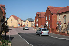

 Cotford St Luke
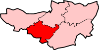
Cotford St Luke shown within SomersetOS grid reference ST167273 District Taunton Deane Shire county Somerset Region South West Country England Sovereign state United Kingdom Post town Taunton Postcode district TA4 Dialling code 01823 Police Avon and Somerset Fire Devon and Somerset Ambulance South Western EU Parliament South West England UK Parliament Taunton Deane List of places: UK • England • Somerset Cotford St Luke is a village in the district of Taunton Deane, Somerset, England. Cotford St Luke is a new village that was established following the closure of Tone Vale Hospital and Cotford Asylum in the 1990s. The old asylum buildings were converted into housing commencing in the late 1990s.[1]
The former hospital St Luke's chapel, which is a Grade II listed building built in the 1890s,[2] was converted into a public house/restaurant and opened on 13 July 2008, after being derelict for 18 years. The pub closed in May 2011 and is currently for sale.
Cotford St Luke Community Primary School is situated on the edge of the village.[3] It was built on what were the grounds of the asylum playing fields and opened in September 2004. The school has 10 classes and caters for children from 4 to 11 years, with a pre-school on site for children from the age of 3 years.
Dene Barton Community Hospital is a modern hospital located in the village, and has 40 beds for elderly patients needing acute care or rehabilitation.[4]
Cotford St Luke is served by numbers 25, 25A and 25B scheduled bus services provided by First Group on the Taunton - Wiveliscombe - Barnstaple route. These run approximately every half hour daytimes Monday to Saturday in both directions. Other destinations, including Bridgwater and Kingston St Mary are also served but less frequently.
On 5 May 2011, Cotford St Luke Parish Council was formed after previously being part of Bishop's Lydeard and Cothelstone Parish Council. Seven Parish Councillors were elected un-opposed.[5]
References
- ^ "Cotford St Luke". Exmorian. http://www.exmoorian.co.uk/cotford-st-luke.htm. Retrieved 1 April 2011.
- ^ "Church of St Luke (Chapel) at Tone Vale Hospital". Images of England. English Heritage. http://www.imagesofengland.org.uk/Details/Default.aspx?id=361629. Retrieved 1 April 2011.
- ^ "School Website". Cotford St Luke Primary School. http://www.cotfordstlukeprimary.co.uk/. Retrieved 1 April 2011.
- ^ "Dene Barton Community Hospital". Somerset Community Health. http://www.somerset.nhs.uk/community/our-services2/community-hospitals/dene-barton-community-hospital/. Retrieved 2 April 2011.
- ^ "Local Election Results 2011". http://www.tauntondeane.gov.uk/irj/go/km/docs/CouncilDocuments/TDBC/Documents/Current%20Elections/Statement%20of%20Persons%20Nominated%20-%20Parish.pdf. Retrieved 11 May 2011.
External links
- Cotford St Luke at the Open Directory Project
 Media related to Cotford St Luke at Wikimedia Commons
Towns, villages and hamlets in the Taunton Deane borough of Somerset, England  Ashbrittle · Ash Priors · Bathealton · Bickenhall · Bishop's Hull · Bishops Lydeard · Bradford on Tone · Burrowbridge · Cheddon Fitzpaine · Chipstable · Churchstanton · Combe Florey · Comeytrowe · Corfe · Cotford St Luke · Cothelstone · Creech St Michael · Curland · Durston · Fitzhead · Halse · Hatch Beauchamp · Kingston St Mary · Langford Budville · Lydeard St Lawrence · Milverton · North Curry · Norton Fitzwarren · Nynehead · Oake · Orchard Portman · Otterford · Pitminster · Ruishton · Sampford Arundel · Staple Fitzpaine · Stawley · Stoke St Gregory · Stoke St Mary · Taunton · Thornfalcon · Tolland · Trull · Wellington · Wellington Without · West Bagborough · West Buckland · West Hatch · West Monkton · WiveliscombeCategories:
- Villages in Taunton Deane
- Civil parishes in Somerset


Wikimedia Foundation. 2010.